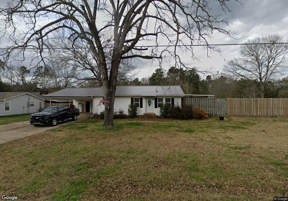
117 Lamar Rd Choudrant, LA 71227
Estimated Value: $162,000 - $265,000
Studio
--
Bath
1,244
Sq Ft
$176/Sq Ft
Est. Value
About This Home
This home is located at 117 Lamar Rd, Choudrant, LA 71227 and is currently estimated at $218,417, approximately $175 per square foot. 117 Lamar Rd is a home located in Lincoln Parish with nearby schools including Choudrant Elementary School, Choudrant High School, and Ruston Junior High School.
Ownership History
Date
Name
Owned For
Owner Type
Purchase Details
Closed on
May 4, 2011
Sold by
Andrews Pamela Ann Howard and Howard Pamela Ann
Bought by
Ward Michael Wayne
Current Estimated Value
Home Financials for this Owner
Home Financials are based on the most recent Mortgage that was taken out on this home.
Original Mortgage
$89,374
Outstanding Balance
$61,086
Interest Rate
4.91%
Mortgage Type
FHA
Estimated Equity
$157,331
Purchase Details
Closed on
May 23, 2007
Sold by
Mayzel Bennet Sharon
Bought by
Howard Pamela Ann
Home Financials for this Owner
Home Financials are based on the most recent Mortgage that was taken out on this home.
Original Mortgage
$93,000
Interest Rate
6.22%
Mortgage Type
New Conventional
Purchase Details
Closed on
Feb 10, 2006
Sold by
Hay John Randolph and Benneth Hay Linda Dianne
Bought by
Mayzel Bennett Sharon
Home Financials for this Owner
Home Financials are based on the most recent Mortgage that was taken out on this home.
Original Mortgage
$50,000,000
Interest Rate
6.18%
Mortgage Type
Future Advance Clause Open End Mortgage
Create a Home Valuation Report for This Property
The Home Valuation Report is an in-depth analysis detailing your home's value as well as a comparison with similar homes in the area
Purchase History
| Date | Buyer | Sale Price | Title Company |
|---|---|---|---|
| Ward Michael Wayne | $91,700 | None Available | |
| Howard Pamela Ann | $93,000 | None Available | |
| Mayzel Bennett Sharon | $28,000 | None Available |
Source: Public Records
Mortgage History
| Date | Status | Borrower | Loan Amount |
|---|---|---|---|
| Open | Ward Michael Wayne | $89,374 | |
| Previous Owner | Howard Pamela Ann | $93,000 | |
| Previous Owner | Mayzel Bennett Sharon | $50,000,000 |
Source: Public Records
Tax History
| Year | Tax Paid | Tax Assessment Tax Assessment Total Assessment is a certain percentage of the fair market value that is determined by local assessors to be the total taxable value of land and additions on the property. | Land | Improvement |
|---|---|---|---|---|
| 2025 | $1,036 | $13,409 | $1,890 | $11,519 |
| 2024 | $1,036 | $13,410 | $1,890 | $11,520 |
| 2023 | $852 | $10,596 | $1,491 | $9,105 |
| 2022 | $846 | $10,596 | $1,491 | $9,105 |
| 2021 | $832 | $10,597 | $1,491 | $9,106 |
| 2020 | $739 | $9,390 | $1,491 | $7,899 |
| 2019 | $750 | $9,390 | $1,491 | $7,899 |
| 2018 | $750 | $9,390 | $1,491 | $7,899 |
| 2017 | $752 | $9,390 | $1,491 | $7,899 |
| 2016 | $768 | $0 | $0 | $0 |
| 2015 | $710 | $8,038 | $1,260 | $6,778 |
| 2013 | $681 | $7,588 | $1,260 | $6,328 |
Source: Public Records
Map
Nearby Homes
- 0 N Depot St
- 510 Louisiana 556
- 00 Cheatwood Rd
- 1732 Highway 80
- 634 Cheatwood Rd
- 5116 Highway 145
- 165 Loblolly Ln
- 147 Loblolly Ln
- 0 Spillers Rd
- 1271 Emory Rd
- 220 Crestview Dr
- 120 Lanes End Dr
- 448 Loblolly Ln
- 1950 Louisiana 821
- 201 Vintage Ln
- 00 Par Road 43
- 120 Douglas Ln
- 1249 Highway 820
- 145 Woodshire Ln
- 197 Baxter Rd
Your Personal Tour Guide
Ask me questions while you tour the home.