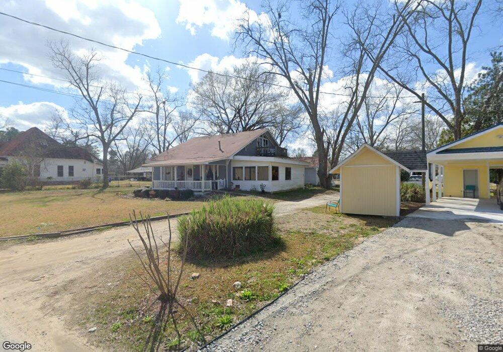
117 Neals Mill Rd Dearing, GA 30808
Estimated Value: $225,000 - $263,000
About This Home
This home is located at 117 Neals Mill Rd, Dearing, GA 30808 and is currently estimated at $241,789, approximately $127 per square foot. 117 Neals Mill Rd is a home located in McDuffie County with nearby schools including Thomson High School.
Ownership History
We collect this data history from publicly available records. To have your information removed, we recommend requesting removal directly through your county’s website.
Purchase Details
Purchase Details
Purchase Details
Purchase Details
Purchase Details
Purchase Details
Purchase History
We collect this data history from publicly available records. To have your information removed, we recommend requesting removal directly through your county’s website.
| Date | Buyer | Sale Price | Title Company |
|---|---|---|---|
| $38,000 | -- | ||
| $31,000 | -- | ||
| $67,032 | -- | ||
| $45,000 | -- | ||
| -- | -- | ||
| $90,800 | -- | ||
| $65,000 | -- |
Tax History
We collect this data history from publicly available records. To have your information removed, we recommend requesting removal directly through your county’s website.
| Year | Tax Paid | Tax Assessment Tax Assessment Total Assessment is a certain percentage of the fair market value that is determined by local assessors to be the total taxable value of land and additions on the property. | Land | Improvement |
|---|---|---|---|---|
| 2025 | $2,121 | $85,614 | $4,672 | $80,942 |
| 2024 | $2,121 | $81,618 | $4,536 | $77,082 |
| 2023 | $2,056 | $78,145 | $4,320 | $73,825 |
| 2022 | $1,491 | $58,406 | $2,592 | $55,814 |
| 2021 | $1,268 | $47,852 | $2,592 | $45,260 |
| 2020 | $1,349 | $47,849 | $4,320 | $43,529 |
| 2019 | $1,363 | $47,849 | $4,320 | $43,529 |
| 2018 | $1,382 | $47,849 | $4,320 | $43,529 |
| 2017 | $1,335 | $47,849 | $4,320 | $43,529 |
| 2016 | $1,349 | $47,849 | $4,320 | $43,529 |
| 2015 | $1,232 | $47,849 | $4,320 | $43,529 |
| 2014 | $600 | $23,274 | $4,320 | $18,954 |
| 2013 | -- | $22,248 | $4,320 | $17,928 |
Map
- 155 McGahee Ave
- 3641 Hillman Gay Rd
- 3191 Old Augusta Rd
- 3175 Old Augusta Rd
- 3612 Deerfield Rd
- 2719 Old Augusta Rd
- 4327 Iron Hill Rd
- 2748 Pine Forest Dr
- 4559 Hillman Gay Rd
- 841 Sweet Grass Cir
- 850 Sweet Grass Cir
- 840 Sweet Grass Cir
- 3776 Wire Rd
- 3766 Wire Rd
- 3756 Wire Rd
- 856 Sweet Grass Cir
- 227 Pebble Ln
- 140 Pebble Ln
- 829 Sweet Grass Cir
- 826 Sweet Grass Cir
- 117 Neals Mill Rd
- 4623 Augusta Hwy
- 4609 Augusta Hwy
- 129 Neals Mill Rd
- 125 First St
- 124 Neals Mill Rd
- 134 Neals Mill Rd
- 4599 Augusta Hwy
- 117 First St
- 118 S Main St
- 4630 Augusta Hwy
- 126 S Main St
- 134 First St
- 148 First St
- 138 S Main St
- 2959 Augusta Hwy
- 3035 Augusta Hwy
- 000 Augusta Hwy
- 146 Neals Mill Rd
- 157 Neals Mill Rd
Ask me questions while you tour the home.