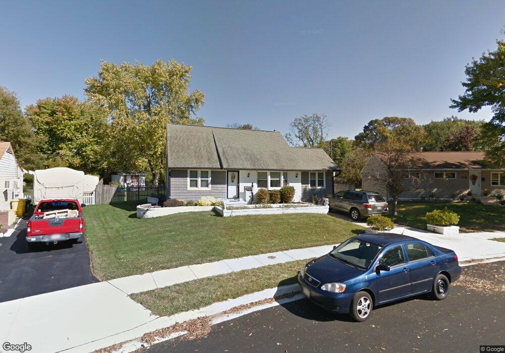
117 Thomas Rd Glen Burnie, MD 21060
Estimated Value: $393,000 - $426,000
Studio
2
Baths
1,513
Sq Ft
$269/Sq Ft
Est. Value
About This Home
This home is located at 117 Thomas Rd, Glen Burnie, MD 21060 and is currently estimated at $406,453, approximately $268 per square foot. 117 Thomas Rd is a home located in Anne Arundel County with nearby schools including Point Pleasant Elementary School, Marley Middle School, and Glen Burnie High School.
Ownership History
Date
Name
Owned For
Owner Type
Purchase Details
Closed on
Nov 10, 2021
Sold by
Devaney David C and Devaney Kathryn M
Bought by
Devaney-Pallozzi Kathryn M
Current Estimated Value
Home Financials for this Owner
Home Financials are based on the most recent Mortgage that was taken out on this home.
Original Mortgage
$272,000
Interest Rate
3.05%
Mortgage Type
New Conventional
Purchase Details
Closed on
Jan 31, 2003
Sold by
Devaney David C
Bought by
Devaney David C and Devaney Kathryn M
Purchase Details
Closed on
Jan 25, 1999
Sold by
Fiori Anthony M
Bought by
Devaney David C and Pallozzi Kathryn M G
Purchase Details
Closed on
Nov 21, 1997
Sold by
Fiori Ronda D
Bought by
Fiori Anthony M and Fiori Ronda D
Purchase Details
Closed on
Nov 17, 1997
Sold by
Hensley Raymond
Bought by
Fiori Ronda D
Create a Home Valuation Report for This Property
The Home Valuation Report is an in-depth analysis detailing your home's value as well as a comparison with similar homes in the area
Home Values in the Area
Average Home Value in this Area
Purchase History
| Date | Buyer | Sale Price | Title Company |
|---|---|---|---|
| Devaney-Pallozzi Kathryn M | -- | Amrock | |
| Devaney David C | -- | -- | |
| Devaney David C | $125,500 | -- | |
| Fiori Anthony M | -- | -- | |
| Fiori Ronda D | -- | -- |
Source: Public Records
Mortgage History
| Date | Status | Borrower | Loan Amount |
|---|---|---|---|
| Previous Owner | Devaney-Pallozzi Kathryn M | $272,000 | |
| Closed | Fiori Anthony M | -- |
Source: Public Records
Tax History
| Year | Tax Paid | Tax Assessment Tax Assessment Total Assessment is a certain percentage of the fair market value that is determined by local assessors to be the total taxable value of land and additions on the property. | Land | Improvement |
|---|---|---|---|---|
| 2025 | $2,701 | $335,900 | $166,200 | $169,700 |
| 2024 | $2,701 | $309,200 | $0 | $0 |
| 2023 | $2,600 | $282,500 | $0 | $0 |
| 2022 | $2,407 | $255,800 | $128,700 | $127,100 |
| 2020 | $2,299 | $254,933 | $0 | $0 |
| 2019 | $4,435 | $254,500 | $118,700 | $135,800 |
| 2018 | $2,405 | $237,167 | $0 | $0 |
| 2017 | $2,082 | $219,833 | $0 | $0 |
| 2016 | -- | $202,500 | $0 | $0 |
| 2015 | -- | $202,500 | $0 | $0 |
| 2014 | -- | $202,500 | $0 | $0 |
Source: Public Records
Map
Nearby Homes
- 19 Leymar Rd
- 117 Midland Rd
- 131 Midland Rd
- 143 Midland Rd
- 117 Bonnie View Rd
- 309 Margate Dr
- 214 Saltgrass Dr Unit 16
- 161 Margate Dr
- 510 Creek Crossing Ln
- 400 Summit Ave
- 229 Saltgrass Dr Unit 229
- 1318 Meadowvale Rd
- 7327 E Furnace Branch Rd
- 1322 Meadowvale Rd
- 206 Highland Rd
- 907 Princeton Terrace
- 350 Gatewater Ct Unit A
- 352 Gatewater Ct Unit A
- 4 Wendover Rd
- 454 Renfro Ct
Your Personal Tour Guide
Ask me questions while you tour the home.