
Seller's Agent in 2025
Taylor Thanos
Realty Unlimited, LLC
(478) 284-1574
193 Total Sales
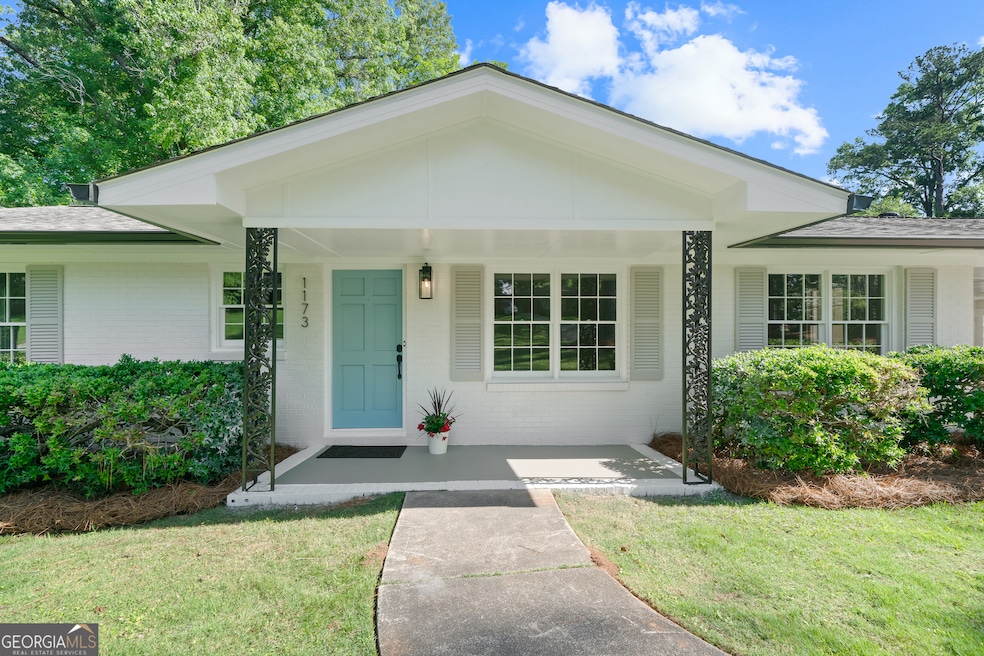
You've got to see this impeccably renovated N. Macon stunner!! No detail was spared in its picture-perfect redesign, and every surface was thoughtfully finished with craftsmanship of the highest quality. Be in awe when you see the brand-new, open-concept kitchen with quartz countertops, tile backsplash and accent wall, all-new cabinetry with soft-close doors and drawers, designer shelving, and premium stainless-steel appliances. Feel a sense of warmth in the family room that walks out to an expansive private patio perfect for gatherings, and overlooks a large, fully fenced lawn. The primary ensuite was beautifully rebuilt with a walk-in tile shower, and your guests will love the elegant and new hall bathroom. Enjoy peace of mind and energy efficiency with a brand-new roof and gutters, new blown-in attic insulation, and brand-new HVAC system. Don't miss this opportunity! Schedule a private tour today and experience this exceptional like-new home for yourself!
Last Agent to Sell the Property
Realty Unlimited, LLC License #294613 Listed on: 05/26/2025
| Date | Type | Sale Price | Title Company |
|---|---|---|---|
| Warranty Deed | $270,400 | None Listed On Document | |
| Warranty Deed | $110,000 | None Listed On Document | |
| Warranty Deed | $110,000 | None Listed On Document | |
| Limited Warranty Deed | $102,500 | None Available | |
| Warranty Deed | $104,000 | None Available | |
| Warranty Deed | $90,600 | -- | |
| Warranty Deed | $104,000 | -- | |
| Limited Warranty Deed | $90,000 | None Available | |
| Warranty Deed | $90,000 | -- |
| Date | Status | Loan Amount | Loan Type |
|---|---|---|---|
| Open | $162,240 | New Conventional | |
| Previous Owner | $72,000 | Adjustable Rate Mortgage/ARM |
| Date | Event | Price | List to Sale | Price per Sq Ft |
|---|---|---|---|---|
| 06/24/2025 06/24/25 | Sold | $270,400 | -1.7% | $159 / Sq Ft |
| 05/30/2025 05/30/25 | Pending | -- | -- | -- |
| 05/26/2025 05/26/25 | For Sale | $275,000 | -- | $161 / Sq Ft |
| Year | Tax Paid | Tax Assessment Tax Assessment Total Assessment is a certain percentage of the fair market value that is determined by local assessors to be the total taxable value of land and additions on the property. | Land | Improvement |
|---|---|---|---|---|
| 2025 | $1,587 | $64,582 | $10,250 | $54,332 |
| 2024 | $1,640 | $64,582 | $10,250 | $54,332 |
| 2023 | $1,438 | $48,541 | $8,200 | $40,341 |
| 2022 | $1,868 | $53,963 | $7,896 | $46,067 |
| 2021 | $1,785 | $46,982 | $6,633 | $40,349 |
| 2020 | $1,777 | $45,778 | $6,633 | $39,145 |
| 2019 | $1,604 | $40,963 | $6,633 | $34,330 |
| 2018 | $2,396 | $36,967 | $6,001 | $30,966 |
| 2017 | $1,308 | $34,899 | $6,338 | $28,561 |
| 2016 | $1,155 | $33,396 | $6,338 | $27,058 |
| 2015 | $1,293 | $33,396 | $6,338 | $27,058 |
| 2014 | $1,663 | $35,604 | $7,042 | $28,561 |
Seller's Agent in 2025
Taylor Thanos
Realty Unlimited, LLC
(478) 284-1574
193 Total Sales
Buyer's Agent in 2025
Nicole Wallace
Keller Williams Middle Georgia
(478) 955-6443
110 Total Sales
Source: Georgia MLS
MLS Number: 10529848
APN: N043-0034
Disclaimer: Certain information contained herein is derived from information provided by parties other than Homes.com. All information provided is deemed reliable, but is not guaranteed to be accurate and should be independently verified.
![]() The data relating to real estate for sale on this web site comes in part from the Broker Reciprocity Program of Georgia MLS. Real estate listings held by brokerage firms other than Redfin are marked with the Broker Reciprocity logo and detailed information about them includes the name of the listing brokers. Information deemed reliable but not guaranteed. Copyright 2026 Georgia MLS. All rights reserved.
The data relating to real estate for sale on this web site comes in part from the Broker Reciprocity Program of Georgia MLS. Real estate listings held by brokerage firms other than Redfin are marked with the Broker Reciprocity logo and detailed information about them includes the name of the listing brokers. Information deemed reliable but not guaranteed. Copyright 2026 Georgia MLS. All rights reserved.
Ask me questions while you tour the home.