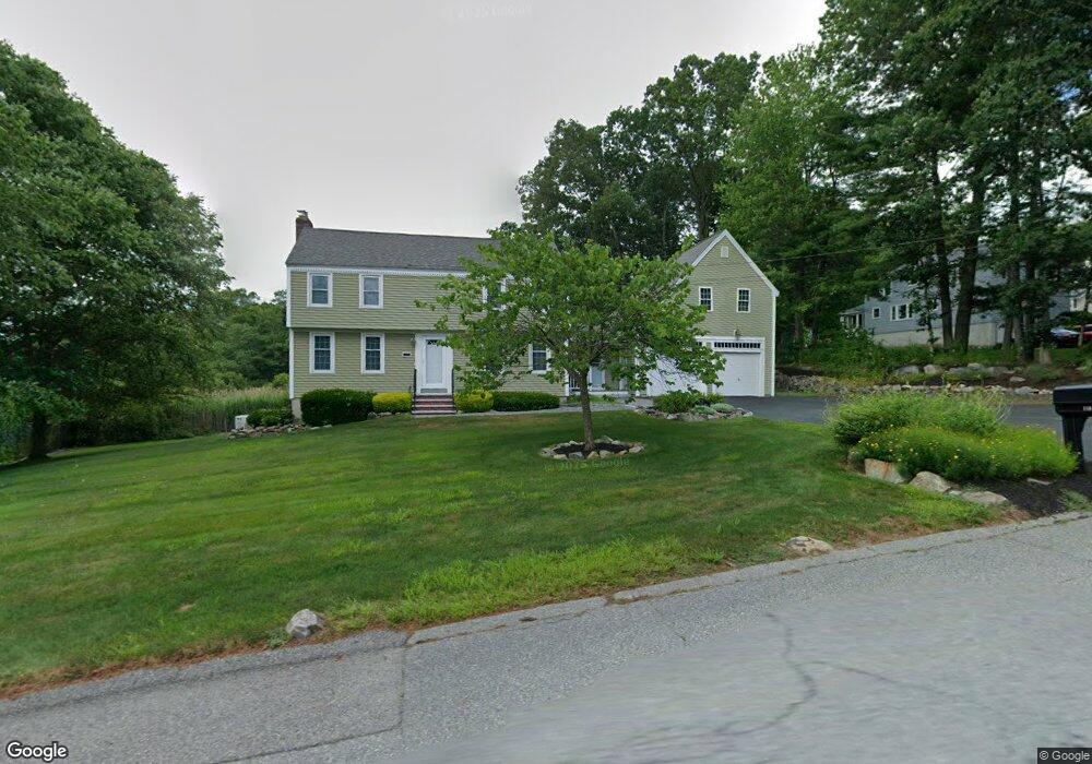
118 Cranberry Rd Dracut, MA 01826
Estimated Value: $700,772 - $793,000
About This Home
This home is located at 118 Cranberry Rd, Dracut, MA 01826 and is currently estimated at $739,193, approximately $368 per square foot. 118 Cranberry Rd is a home located in Middlesex County with nearby schools including Joseph A. Campbell Elementary School, Richardson Middle School, and Dracut Senior High School.
Ownership History
We collect this data history from publicly available records. To have your information removed, we recommend requesting removal directly through your county’s website.
Purchase Details
Purchase Details
Purchase Details
Home Values in the Area
Average Home Value in this Area
Purchase History
We collect this data history from publicly available records. To have your information removed, we recommend requesting removal directly through your county’s website.
| Date | Buyer | Sale Price | Title Company |
|---|---|---|---|
| -- | None Available | ||
| $259,900 | -- | ||
| $151,000 | -- |
Mortgage History
We collect this data history from publicly available records. To have your information removed, we recommend requesting removal directly through your county’s website.
| Date | Status | Borrower | Loan Amount |
|---|---|---|---|
| Previous Owner | $240,000 | ||
| Previous Owner | $50,000 | ||
| Previous Owner | $115,000 |
Tax History
We collect this data history from publicly available records. To have your information removed, we recommend requesting removal directly through your county’s website.
| Year | Tax Paid | Tax Assessment Tax Assessment Total Assessment is a certain percentage of the fair market value that is determined by local assessors to be the total taxable value of land and additions on the property. | Land | Improvement |
|---|---|---|---|---|
| 2025 | $6,762 | $668,200 | $242,800 | $425,400 |
| 2024 | $6,591 | $630,700 | $231,400 | $399,300 |
| 2023 | $6,382 | $551,100 | $201,400 | $349,700 |
| 2022 | $6,143 | $499,800 | $183,200 | $316,600 |
| 2021 | $6,060 | $465,800 | $166,300 | $299,500 |
| 2020 | $5,857 | $438,700 | $161,300 | $277,400 |
| 2019 | $5,591 | $406,600 | $153,600 | $253,000 |
| 2018 | $5,592 | $395,500 | $153,600 | $241,900 |
| 2017 | $5,542 | $395,500 | $153,600 | $241,900 |
| 2016 | $5,564 | $374,900 | $154,400 | $220,500 |
| 2015 | -- | $359,000 | $154,400 | $204,600 |
| 2014 | $4,956 | $342,000 | $154,400 | $187,600 |
Map
- 207 Trout Brook Rd
- 215 Lexington Rd
- 24 Novak Cir
- 20 Farm Pond Rd
- 115 Stuart Ave Unit 20
- 58 Leo Ave
- 30 Parker Rd
- 10 Lanseigne St
- 341 Broadway Rd
- 80 Brigham Ave
- 4 Hazelwood Ave Unit 12
- 4 Hazelwood Ave Unit 11
- 23 Fox Hill Ln Unit 23
- 15 Wildwood St Unit B19
- 12 Allen St
- 785 Broadway Rd
- 289 Burnham Rd
- 71 Brook St
- 185 18th St
- 762 Merrimack Ave
- 14 Trout Brook Rd
- 119 Cranberry Rd
- 24 Trout Brook Rd
- 109 Cranberry Rd
- 108 Cranberry Rd
- 140 Cranberry Rd
- 139 Cranberry Rd
- 139 Cranberry Rd Unit 139
- 34 Trout Brook Rd
- 17 Trout Brook Rd
- 27 Trout Brook Rd
- 92 Cranberry Rd
- 103 Cranberry Rd
- 44 Trout Brook Rd
- 35 Trout Brook Rd
- 149 Cranberry Rd
- 82 Cranberry Rd
- 93 Cranberry Rd
- 15 Mulberry Rd
- 44 Chestnut Rd
Ask me questions while you tour the home.