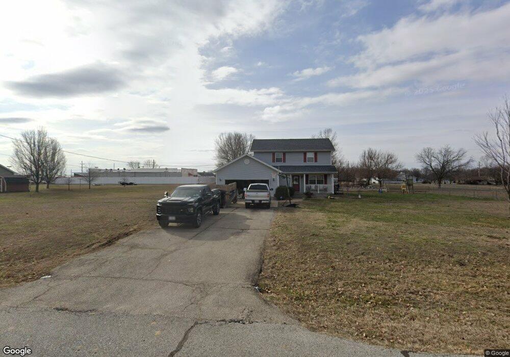
1186 E Sunset Dr Oronogo, MO 64855
Estimated Value: $244,000 - $290,000
5
Beds
4
Baths
2,100
Sq Ft
$129/Sq Ft
Est. Value
About This Home
This home is located at 1186 E Sunset Dr, Oronogo, MO 64855 and is currently estimated at $271,495, approximately $129 per square foot. 1186 E Sunset Dr is a home located in Jasper County with nearby schools including Webb City High School.
Ownership History
Date
Name
Owned For
Owner Type
Purchase Details
Closed on
Aug 7, 2008
Sold by
Us Bank Na
Bought by
Pearce Donald J and Pearce Emily D
Current Estimated Value
Home Financials for this Owner
Home Financials are based on the most recent Mortgage that was taken out on this home.
Original Mortgage
$115,192
Outstanding Balance
$75,473
Interest Rate
6.38%
Mortgage Type
FHA
Estimated Equity
$196,022
Purchase Details
Closed on
May 5, 2008
Sold by
Anger Henry E and Anger Silvia R
Bought by
U S Bank Na and Home Equity Asset Trust 2005-7 Home Equi
Purchase Details
Closed on
Jul 7, 2005
Sold by
Mcafee Gerry and Mcafee Karen K
Bought by
Anger Henry E and Anger Silvia R
Home Financials for this Owner
Home Financials are based on the most recent Mortgage that was taken out on this home.
Original Mortgage
$104,560
Interest Rate
8.74%
Mortgage Type
Fannie Mae Freddie Mac
Create a Home Valuation Report for This Property
The Home Valuation Report is an in-depth analysis detailing your home's value as well as a comparison with similar homes in the area
Home Values in the Area
Average Home Value in this Area
Purchase History
| Date | Buyer | Sale Price | Title Company |
|---|---|---|---|
| Pearce Donald J | -- | Jct | |
| U S Bank Na | $97,009 | None Available | |
| Anger Henry E | -- | Fatco |
Source: Public Records
Mortgage History
| Date | Status | Borrower | Loan Amount |
|---|---|---|---|
| Open | Pearce Donald J | $115,192 | |
| Previous Owner | Anger Henry E | $104,560 | |
| Closed | Anger Henry E | $26,140 |
Source: Public Records
Tax History
| Year | Tax Paid | Tax Assessment Tax Assessment Total Assessment is a certain percentage of the fair market value that is determined by local assessors to be the total taxable value of land and additions on the property. | Land | Improvement |
|---|---|---|---|---|
| 2025 | $1,395 | $28,500 | $6,960 | $21,540 |
| 2024 | $1,396 | $26,880 | $6,960 | $19,920 |
| 2023 | $1,396 | $26,880 | $6,960 | $19,920 |
| 2022 | $1,392 | $26,890 | $6,960 | $19,930 |
| 2021 | $1,384 | $26,890 | $6,960 | $19,930 |
| 2020 | $1,244 | $25,180 | $6,960 | $18,220 |
| 2019 | $1,247 | $25,180 | $6,960 | $18,220 |
| 2018 | $1,245 | $25,200 | $0 | $0 |
| 2016 | $1,247 | $27,020 | $0 | $0 |
Source: Public Records
Map
Nearby Homes
- 901 D Hwy
- 000 State Highway 96
- 9945 County Lane 217
- 1106 Pawpaw Place
- 913 Samthea Dr
- TBD 3 87 Acres County Lane 228
- 908 Gregory Dr
- 2177 Webbwood Dr
- 116 Katey Ln
- 25629 Kafir Rd
- 2306 N Greystone Square
- 329 Sidney Ln
- 342 Swaden Ln
- 337 Swaden Ln
- 348 E Greystone Square
- 340 E Greystone Square
- 524 Mineral St
- TBD S 4th St
- 321 S 4th St
- 8940 County Lane 214
- 1150 E Sunset Dr
- 1220 E Sunset Dr
- 414 E Sunset Dr
- 1187 E State Highway 96
- 1217 E Sunset Dr
- 1149 E State Highway 96
- 1091 E Sunset Dr
- 1108 E Sunset Dr
- 1225 E Sunset Dr
- 1201 State Highway 96
- 1201 E State Highway 96
- 1201 E State Highway 96
- 901 N Highway D
- 1113 E State Highway 96
- 793 State Highway 96
- 1067 E Sunset Dr
- 1109 E Sunset Dr
- 1164 E State Highway 96
- 1172 Sunrise Dr
- 1162 E Sunrise Dr
Your Personal Tour Guide
Ask me questions while you tour the home.