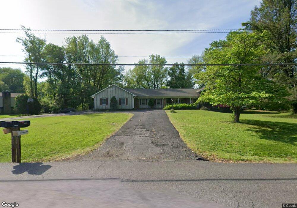
11909 Bennett Rd Herndon, VA 20171
Foxvale NeighborhoodEstimated Value: $939,000 - $1,112,000
4
Beds
4
Baths
2,582
Sq Ft
$392/Sq Ft
Est. Value
About This Home
This home is located at 11909 Bennett Rd, Herndon, VA 20171 and is currently estimated at $1,011,617, approximately $391 per square foot. 11909 Bennett Rd is a home located in Fairfax County with nearby schools including Navy Elementary, Franklin Middle, and Oakton High.
Ownership History
Date
Name
Owned For
Owner Type
Purchase Details
Closed on
Feb 24, 2023
Sold by
Smith-Cohen Deborah R
Bought by
Deborah R Smith-Cohen Revocable Trust
Current Estimated Value
Purchase Details
Closed on
Dec 15, 1998
Sold by
Estate Of Harvey W Mckee
Bought by
Cohen Brian S
Home Financials for this Owner
Home Financials are based on the most recent Mortgage that was taken out on this home.
Original Mortgage
$292,000
Interest Rate
6.85%
Create a Home Valuation Report for This Property
The Home Valuation Report is an in-depth analysis detailing your home's value as well as a comparison with similar homes in the area
Home Values in the Area
Average Home Value in this Area
Purchase History
| Date | Buyer | Sale Price | Title Company |
|---|---|---|---|
| Deborah R Smith-Cohen Revocable Trust | -- | -- | |
| Deborah R Smith-Cohen Revocable Trust | -- | None Listed On Document | |
| Cohen Brian S | $365,000 | -- |
Source: Public Records
Mortgage History
| Date | Status | Borrower | Loan Amount |
|---|---|---|---|
| Previous Owner | Cohen Brian S | $292,000 |
Source: Public Records
Tax History
| Year | Tax Paid | Tax Assessment Tax Assessment Total Assessment is a certain percentage of the fair market value that is determined by local assessors to be the total taxable value of land and additions on the property. | Land | Improvement |
|---|---|---|---|---|
| 2025 | $10,700 | $964,760 | $413,000 | $551,760 |
| 2024 | $10,700 | $923,610 | $413,000 | $510,610 |
| 2023 | $10,628 | $941,760 | $413,000 | $528,760 |
| 2022 | $10,201 | $892,090 | $403,000 | $489,090 |
| 2021 | $9,537 | $812,680 | $378,000 | $434,680 |
| 2020 | $8,619 | $728,300 | $363,000 | $365,300 |
| 2019 | $8,319 | $702,900 | $363,000 | $339,900 |
| 2018 | $8,233 | $715,880 | $363,000 | $352,880 |
| 2017 | $7,844 | $675,600 | $333,000 | $342,600 |
| 2016 | $7,827 | $675,600 | $333,000 | $342,600 |
Source: Public Records
Map
Nearby Homes
- 11713 Ayreshire Rd
- 12136 Westwood Hills Dr
- 11732 Saddle Crescent Cir
- 11728 Stuart Mill Rd
- 11608 Helmont Dr
- 11561 Stuart Mill Rd
- 12321 Folkstone Dr
- 11704 Foxvale Ct
- 12390 Falkirk Dr
- 2926 Fort Lee St
- 11328 Vale Rd
- 3140 Searsmont Place
- 3303 Lauren Oaks Ct
- 3142 Searsmont Place
- 11817 Blue Spruce Rd
- 3144 Searsmont Place
- 3203 W Ox Rd
- 12405 Myterra Way
- 3106 Hunt Rd
- 3406 Lyrac St
- 11911 Bennett Rd
- 11905 Bennett Rd
- 11990 Star Ct
- 11913 Bennett Rd
- 11992 Star Ct
- 11910 Bennett Rd
- 11904 Bennett Rd
- 11915 Bennett Rd
- 2990 Fox Mill Rd
- 2994 Fox Mill Rd
- 11912 Bennett Rd
- 11994 Star Ct
- 2998 Fox Mill Rd
- 11991 Star Ct
- 3001 Leefield Dr
- 11900 Bennett Rd
- 2937 Leefield Dr
- 3003 Leefield Dr
- 11993 Star Ct
- 2935 Leefield Dr
Your Personal Tour Guide
Ask me questions while you tour the home.