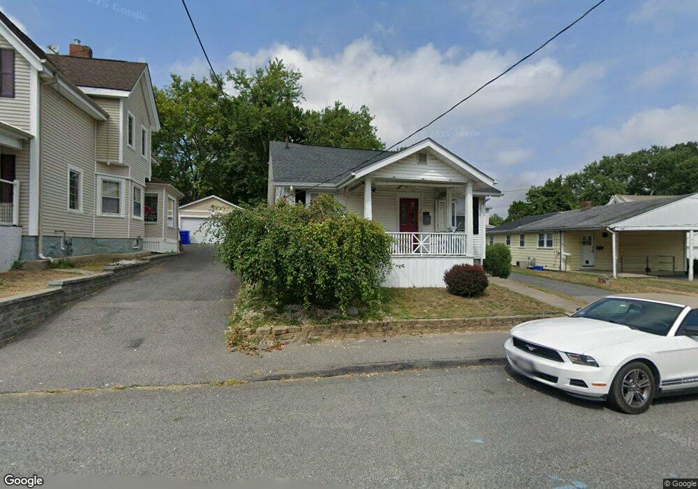
12 E Broadway Taunton, MA 02780
City Center NeighborhoodEstimated Value: $423,035 - $486,000
3
Beds
1
Bath
1,530
Sq Ft
$296/Sq Ft
Est. Value
About This Home
This home is located at 12 E Broadway, Taunton, MA 02780 and is currently estimated at $453,009, approximately $296 per square foot. 12 E Broadway is a home located in Bristol County with nearby schools including Elizabeth Pole School, Taunton High School, and John F. Parker Middle School.
Ownership History
Date
Name
Owned For
Owner Type
Purchase Details
Closed on
Mar 23, 2009
Sold by
Bagge Richard D and Bagge Anne E
Bought by
Barrows Maribeth
Current Estimated Value
Home Financials for this Owner
Home Financials are based on the most recent Mortgage that was taken out on this home.
Original Mortgage
$201,058
Outstanding Balance
$128,657
Interest Rate
5.25%
Mortgage Type
Purchase Money Mortgage
Estimated Equity
$324,352
Purchase Details
Closed on
Oct 25, 2004
Sold by
Bagge Anne E
Bought by
Bagge Anne E and Bagge Richard D
Create a Home Valuation Report for This Property
The Home Valuation Report is an in-depth analysis detailing your home's value as well as a comparison with similar homes in the area
Home Values in the Area
Average Home Value in this Area
Purchase History
| Date | Buyer | Sale Price | Title Company |
|---|---|---|---|
| Barrows Maribeth | $204,800 | -- | |
| Bagge Anne E | -- | -- |
Source: Public Records
Mortgage History
| Date | Status | Borrower | Loan Amount |
|---|---|---|---|
| Open | Barrows Maribeth | $201,058 |
Source: Public Records
Tax History
| Year | Tax Paid | Tax Assessment Tax Assessment Total Assessment is a certain percentage of the fair market value that is determined by local assessors to be the total taxable value of land and additions on the property. | Land | Improvement |
|---|---|---|---|---|
| 2025 | $3,950 | $361,100 | $87,200 | $273,900 |
| 2024 | $3,457 | $308,900 | $87,200 | $221,700 |
| 2023 | $3,333 | $276,600 | $87,200 | $189,400 |
| 2022 | $3,134 | $237,800 | $72,700 | $165,100 |
| 2021 | $2,996 | $211,000 | $66,100 | $144,900 |
| 2020 | $2,794 | $188,000 | $66,100 | $121,900 |
| 2019 | $2,813 | $178,500 | $66,100 | $112,400 |
| 2018 | $2,727 | $173,500 | $65,300 | $108,200 |
| 2017 | $2,460 | $156,600 | $63,000 | $93,600 |
| 2016 | $2,379 | $151,700 | $60,800 | $90,900 |
| 2015 | $2,381 | $158,600 | $62,600 | $96,000 |
| 2014 | $2,288 | $156,600 | $59,200 | $97,400 |
Source: Public Records
Map
Nearby Homes
- 10 E Broadway
- 31 Monica St
- 8 E Broadway
- 9 Cooper Square
- 11 E Broadway Unit 3
- 11 E Broadway
- 11 E Broadway Unit 1
- 7 Cooper Square
- 9 E Broadway
- 11 Cooper Square
- 13 E Broadway
- 6 E Broadway
- 5 Cooper Square
- 16 E Broadway
- 7 E Broadway
- 15 E Broadway
- 3 Cooper Square
- 18 E Broadway Unit 203
- 18 E Broadway Unit 212
- 18 E Broadway Unit 211
Your Personal Tour Guide
Ask me questions while you tour the home.