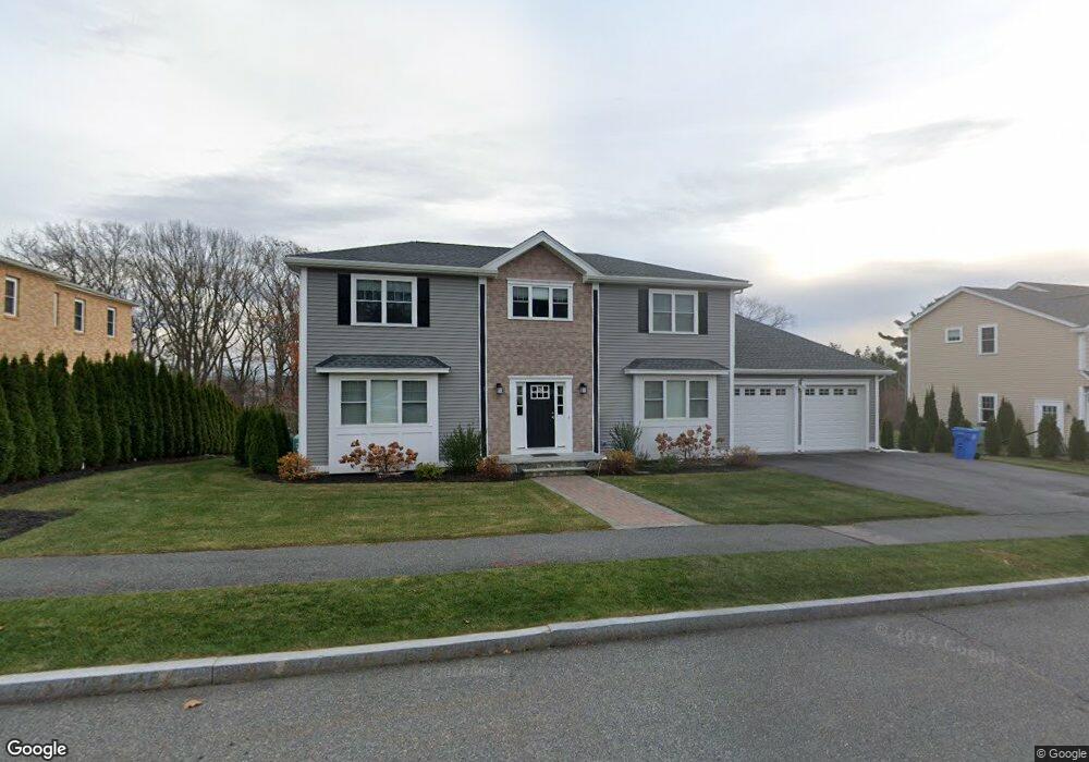
12 Michaelchris Dr Waltham, MA 02452
North Waltham NeighborhoodEstimated Value: $1,450,000 - $1,867,451
About This Home
This home is located at 12 Michaelchris Dr, Waltham, MA 02452 and is currently estimated at $1,650,363, approximately $377 per square foot. 12 Michaelchris Dr is a home located in Middlesex County with nearby schools including Northeast Elementary School, John F Kennedy Middle School, and Waltham Sr High School.
Ownership History
We collect this data history from publicly available records. To have your information removed, we recommend requesting removal directly through your county’s website.
Purchase Details
Home Values in the Area
Average Home Value in this Area
Purchase History
We collect this data history from publicly available records. To have your information removed, we recommend requesting removal directly through your county’s website.
| Date | Buyer | Sale Price | Title Company |
|---|---|---|---|
| -- | -- |
Property History
We collect this data history from publicly available records. To have your information removed, we recommend requesting removal directly through your county’s website.
| Date | Event | Price | List to Sale | Price per Sq Ft |
|---|---|---|---|---|
| 09/01/2024 09/01/24 | For Rent | $7,000 | -- | -- |
Tax History
We collect this data history from publicly available records. To have your information removed, we recommend requesting removal directly through your county’s website.
| Year | Tax Paid | Tax Assessment Tax Assessment Total Assessment is a certain percentage of the fair market value that is determined by local assessors to be the total taxable value of land and additions on the property. | Land | Improvement |
|---|---|---|---|---|
| 2025 | $16,058 | $1,635,200 | $529,200 | $1,106,000 |
| 2024 | $14,284 | $1,481,700 | $505,900 | $975,800 |
| 2023 | $13,881 | $1,345,100 | $459,400 | $885,700 |
| 2022 | $14,674 | $1,317,200 | $459,400 | $857,800 |
| 2021 | $14,150 | $1,250,000 | $440,800 | $809,200 |
| 2020 | $14,471 | $1,211,000 | $443,700 | $767,300 |
| 2019 | $5,039 | $435,700 | $435,700 | $0 |
| 2018 | $5,091 | $403,700 | $403,700 | $0 |
| 2017 | $4,380 | $348,700 | $348,700 | $0 |
| 2016 | $3,962 | $323,700 | $323,700 | $0 |
| 2015 | $3,391 | $258,300 | $258,300 | $0 |
Map
- 196 Doty St
- 281 Bishops Forest Dr Unit 281
- 49 Bishops Forest Dr Unit 49
- 243 Bishops Forest Dr
- 32 Lauricella Ln
- 32 Bishops Forest Dr
- 113 Warwick Ave
- 113 Temple Rd
- 22 Abbott Rd
- 88 Temple Rd
- 542 Trapelo Rd
- 20 College Farm Rd
- 204 Clocktower Dr Unit 311
- 174 Forest St
- 22 Jacqueline Rd Unit F
- 3 Mount Walley Rd
- 104 College Farm Rd
- 995 Trapelo Rd Unit 3
- 184 College Farm Rd
- 53 Hiawatha Ave
- 12 Michaelchris Dr
- 12 Michaelchris Dr
- 6 Michaelchris Dr
- 20 Michaelchris Dr
- 50 Matthew Ln
- Lot 8 Matthew Ln
- 16 Matthew Ln
- 44 Matthew Ln
- 4 Matthew Ln
- 5 Matthew Ln
- 9 Matthew Ln
- 3 Matthew Ln
- 2 Matthew Ln
- 1 Matthew Ln
- Lot 2A Matthew Ln
- 35 Matthew Ln
- 15 Matthew Ln
- 41 Matthew Ln
- 26 Michaelchris Dr
- 27 Matthew Ln
Ask me questions while you tour the home.