
Seller's Agent in 2026
Mary Edeen
Berkshire Hathaway Home Services
(203) 640-1372
40 in this area
70 Total Sales
Estimated Value: $669,998 - $724,000
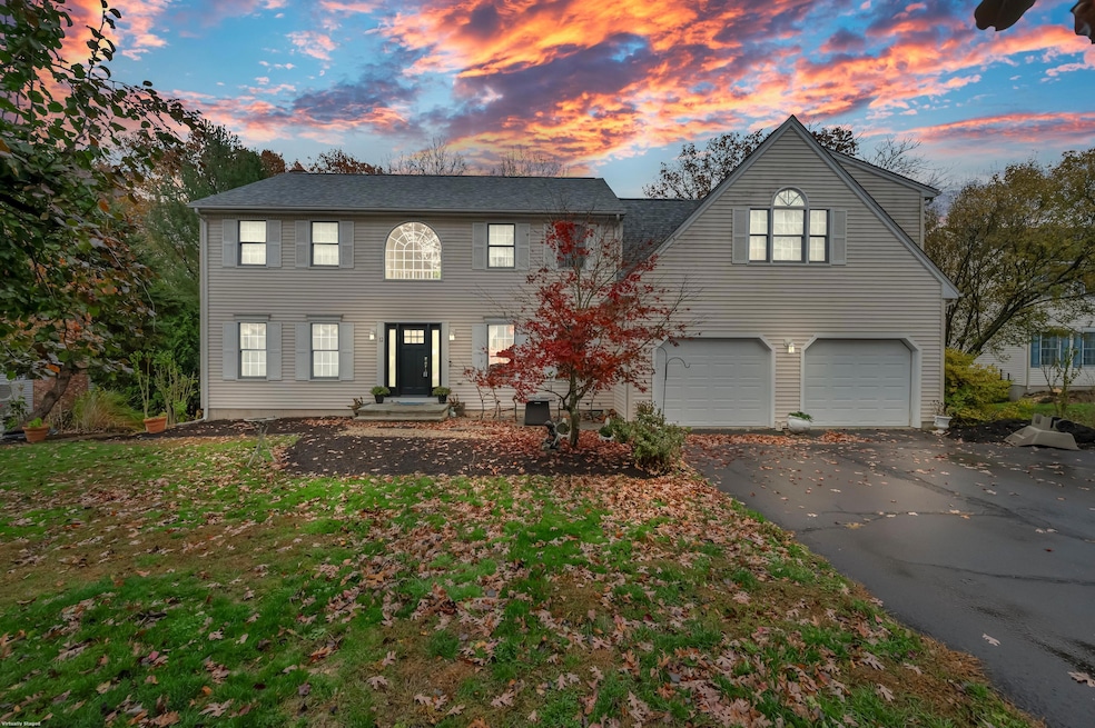
Welcome to this beautiful 3000 sq. ft. Colonial ideally situated on a peaceful cul-de-sac in one of the area's most desirable neighborhoods. As you enter, you're greeted by a split staircase in the foyer that sets the tone for this classic New England style home. The heart of the home is the spacious kitchen featuring timeless white cabinetry, white granite countertops, and warm hardwood floors. A breakfast bar and space for a kitchen perfect for the whole family l. The kitchen opens seamlessly to the inviting family room with a cozy fireplace - perfect for entertaining or relaxing. Sliders to a large deck make outdoor entertaining easy peasy. A formal dining room and living room provide additional space for gatherings. A convenient first-floor laundry room and half bath located off the garage complete the main level. Upstairs, you'll find five generously sized bedrooms, including a large primary suite with a walk-in closet, a private en suite bath, and an additional storage closet. The finished basement offers a place to play pool, games and relax away from the main floor. The walk out access doors make this space easily accessible to the outside area. The backyard offers a private retreat backing up to serene woods, complete with an above-ground pool, beautiful gardens, and mature plantings. This home combines classic charm with modern comfort - a perfect choice for anyone seeking space, privacy, and a welcoming neighborhood setting. *new roof*new doors*
Last Agent to Sell the Property
Berkshire Hathaway NE Prop. Brokerage Phone: (203) 640-1372 License #RES.0784720 Listed on: 11/10/2025
We collect this data history from publicly available records. To have your information removed, we recommend requesting removal directly through your county’s website.
| Date | Buyer | Sale Price | Title Company |
|---|---|---|---|
| Peters John J | $675,000 | -- | |
| Kersey Andrew E | $259,970 | -- | |
| Kersey Andrew E | $259,970 | -- |
We collect this data history from publicly available records. To have your information removed, we recommend requesting removal directly through your county’s website.
| Date | Status | Borrower | Loan Amount |
|---|---|---|---|
| Open | Peters John J | $540,000 | |
| Previous Owner | Kersey Andrew E | $236,000 | |
| Previous Owner | Kersey Andrew E | $183,000 | |
| Previous Owner | Kersey Andrew E | $199,000 | |
| Previous Owner | Kersey Andrew E | $190,000 |
| Date | Event | Price | List to Sale | Price per Sq Ft |
|---|---|---|---|---|
| 01/09/2026 01/09/26 | Sold | $675,000 | 0.0% | $229 / Sq Ft |
| 01/07/2026 01/07/26 | Pending | -- | -- | -- |
| 11/14/2025 11/14/25 | For Sale | $675,000 | -- | $229 / Sq Ft |
| Year | Tax Paid | Tax Assessment Tax Assessment Total Assessment is a certain percentage of the fair market value that is determined by local assessors to be the total taxable value of land and additions on the property. | Land | Improvement |
|---|---|---|---|---|
| 2025 | $10,608 | $439,800 | $94,400 | $345,400 |
| 2024 | $9,164 | $298,900 | $82,900 | $216,000 |
| 2023 | $8,770 | $298,900 | $82,900 | $216,000 |
| 2022 | $8,680 | $298,900 | $82,900 | $216,000 |
| 2021 | $8,525 | $298,900 | $82,900 | $216,000 |
| 2020 | $9,049 | $310,000 | $96,800 | $213,200 |
| 2019 | $9,049 | $310,000 | $96,800 | $213,200 |
| 2018 | $8,878 | $310,000 | $96,800 | $213,200 |
| 2017 | $8,851 | $310,000 | $96,800 | $213,200 |
| 2016 | $8,646 | $310,000 | $96,800 | $213,200 |
| 2015 | $8,788 | $319,900 | $96,700 | $223,200 |
| 2014 | $8,602 | $319,900 | $96,700 | $223,200 |
Seller's Agent in 2026
Mary Edeen
Berkshire Hathaway Home Services
(203) 640-1372
40 in this area
70 Total Sales
Buyer's Agent in 2026
Eileen Smith
Pearce Real Estate
(203) 415-5538
16 in this area
162 Total Sales
Source: SmartMLS
MLS Number: 24139331
APN: WALL-000217-000000-000011
Disclaimer: Certain information contained herein is derived from information provided by parties other than Homes.com. All information provided is deemed reliable, but is not guaranteed to be accurate and should be independently verified.
![]() IDX information is provided exclusively for personal, non-commercial use, and may not be used for any purpose other than to identify prospective properties consumers may be interested in purchasing. Information is deemed reliable but not guaranteed.
IDX information is provided exclusively for personal, non-commercial use, and may not be used for any purpose other than to identify prospective properties consumers may be interested in purchasing. Information is deemed reliable but not guaranteed.
Ask me questions while you tour the home.