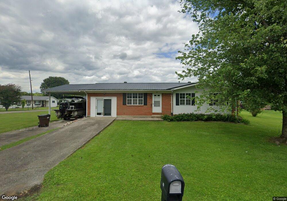
12 Sherman Dr Stanton, KY 40380
Estimated Value: $120,000 - $176,520
3
Beds
2
Baths
1,352
Sq Ft
$106/Sq Ft
Est. Value
About This Home
This home is located at 12 Sherman Dr, Stanton, KY 40380 and is currently estimated at $143,380, approximately $106 per square foot. 12 Sherman Dr is a home located in Powell County with nearby schools including Powell County High School.
Ownership History
Date
Name
Owned For
Owner Type
Purchase Details
Closed on
Jul 31, 2025
Sold by
Pelfrey Dorothea M and Pelfrey Gregory Dale
Bought by
Lawson Garret M
Current Estimated Value
Home Financials for this Owner
Home Financials are based on the most recent Mortgage that was taken out on this home.
Original Mortgage
$150,000
Outstanding Balance
$149,872
Interest Rate
6.81%
Mortgage Type
VA
Estimated Equity
-$6,492
Purchase Details
Closed on
Aug 26, 2021
Sold by
Elam Arlene H
Bought by
Pelfrey Dorothea M
Create a Home Valuation Report for This Property
The Home Valuation Report is an in-depth analysis detailing your home's value as well as a comparison with similar homes in the area
Home Values in the Area
Average Home Value in this Area
Purchase History
| Date | Buyer | Sale Price | Title Company |
|---|---|---|---|
| Lawson Garret M | $150,000 | Bluegrass Land Title | |
| Lawson Garret M | $150,000 | Bluegrass Land Title | |
| Pelfrey Dorothea M | $53,000 | Monica S Lacy Psc |
Source: Public Records
Mortgage History
| Date | Status | Borrower | Loan Amount |
|---|---|---|---|
| Open | Lawson Garret M | $150,000 | |
| Closed | Lawson Garret M | $150,000 |
Source: Public Records
Tax History
| Year | Tax Paid | Tax Assessment Tax Assessment Total Assessment is a certain percentage of the fair market value that is determined by local assessors to be the total taxable value of land and additions on the property. | Land | Improvement |
|---|---|---|---|---|
| 2025 | $334 | $89,000 | $0 | $0 |
| 2024 | $480 | $53,000 | $0 | $0 |
| 2023 | $484 | $53,000 | $0 | $0 |
| 2022 | $475 | $53,000 | $0 | $0 |
| 2021 | $470 | $53,000 | $0 | $0 |
| 2020 | $122 | $53,000 | $0 | $0 |
| 2019 | $112 | $53,000 | $0 | $0 |
| 2018 | $125 | $53,000 | $0 | $0 |
| 2017 | $120 | $53,000 | $0 | $0 |
| 2016 | -- | $53,000 | $0 | $0 |
| 2015 | -- | $53,000 | $0 | $0 |
| 2013 | -- | $53,000 | $0 | $0 |
| 2012 | -- | $53,000 | $0 | $0 |
Source: Public Records
Map
Nearby Homes
- 11 and 13 Miller Dr
- 793 Breckenridge St
- 529 Breckenridge St
- 48 Court St
- 494 & 488 N Main St
- 227 Strange St
- 209 Strange St
- 187 Strange St
- 167 Strange St
- 507 Holman Dr
- 115 Childers Rd
- 740 N Main St
- 221 Halls Ln
- 30 Halls Ln
- 175 N Bend Rd
- 164 E College Ave
- 105 Karin Dr
- lot #15 Pleasant Stream Acres
- 720 S Main St
- 226 Airport Rd
Your Personal Tour Guide
Ask me questions while you tour the home.