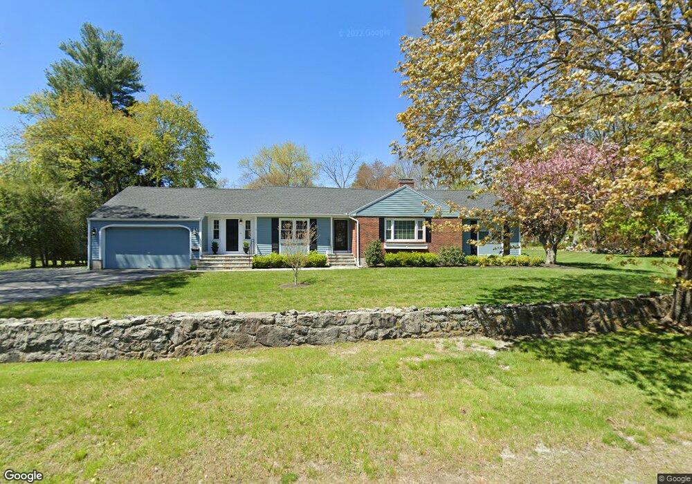
120 Osgood St North Andover, MA 01845
Estimated Value: $839,000 - $916,100
4
Beds
3
Baths
2,250
Sq Ft
$393/Sq Ft
Est. Value
About This Home
This home is located at 120 Osgood St, North Andover, MA 01845 and is currently estimated at $884,775, approximately $393 per square foot. 120 Osgood St is a home located in Essex County with nearby schools including Kittredge Elementary School, North Andover Middle School, and North Andover High School.
Ownership History
Date
Name
Owned For
Owner Type
Purchase Details
Closed on
Sep 30, 1999
Sold by
Osgood Street T
Bought by
Fredo Scot C and Fredo Kristen M
Current Estimated Value
Home Financials for this Owner
Home Financials are based on the most recent Mortgage that was taken out on this home.
Original Mortgage
$180,000
Interest Rate
7.85%
Mortgage Type
Purchase Money Mortgage
Purchase Details
Closed on
Dec 19, 1994
Sold by
Forzese Carmelo A
Bought by
Osgood Street Trust
Create a Home Valuation Report for This Property
The Home Valuation Report is an in-depth analysis detailing your home's value as well as a comparison with similar homes in the area
Home Values in the Area
Average Home Value in this Area
Purchase History
| Date | Buyer | Sale Price | Title Company |
|---|---|---|---|
| Fredo Scot C | $255,000 | -- | |
| Osgood Street Trust | $255,000 | -- |
Source: Public Records
Mortgage History
| Date | Status | Borrower | Loan Amount |
|---|---|---|---|
| Open | Osgood Street Trust | $336,000 | |
| Closed | Osgood Street Trust | $175,500 | |
| Closed | Osgood Street Trust | $180,000 | |
| Previous Owner | Osgood Street Trust | $100,000 |
Source: Public Records
Tax History
| Year | Tax Paid | Tax Assessment Tax Assessment Total Assessment is a certain percentage of the fair market value that is determined by local assessors to be the total taxable value of land and additions on the property. | Land | Improvement |
|---|---|---|---|---|
| 2025 | $9,353 | $830,600 | $408,700 | $421,900 |
| 2024 | $8,973 | $809,100 | $387,200 | $421,900 |
| 2023 | $8,683 | $709,400 | $327,000 | $382,400 |
| 2022 | $8,606 | $636,100 | $296,800 | $339,300 |
| 2021 | $8,261 | $583,000 | $268,900 | $314,100 |
| 2020 | $7,734 | $562,900 | $268,900 | $294,000 |
| 2019 | $7,548 | $562,900 | $268,900 | $294,000 |
| 2018 | $8,179 | $562,900 | $268,900 | $294,000 |
| 2017 | $7,256 | $508,100 | $212,600 | $295,500 |
| 2016 | $6,029 | $422,500 | $211,300 | $211,200 |
| 2015 | $5,927 | $411,900 | $207,200 | $204,700 |
Source: Public Records
Map
Nearby Homes
- 7 Fernview Ave Unit 11
- 21 Fernview Ave Unit 8
- 30 Fernview Ave Unit 4
- 279 Osgood St
- 70 Farrwood Ave Unit 7
- 80 Edgelawn Ave Unit 6
- 78 Edgelawn Ave Unit 7
- 27 Mill Pond
- 37 Lincoln St Unit 39
- 36 Richardson Ave
- 350 Greene St Unit 410
- 350 Greene St Unit 305
- 170 Haverhill St Unit 138
- 13 Walker Rd Unit 12
- 335 Salem St
- 20 Coachmans Ln
- 8 Longwood Dr Unit 310
- 30 Anne Rd
- 94 Main St
- 35 Wood Ave Unit 35
- 110 Osgood St
- 684 Massachusetts Ave
- 678 Massachusetts Ave
- 35 Phillips Common
- 100 Osgood St
- 117 Osgood St
- 129 Osgood St
- 672 Massachusetts Ave
- 27 Phillips Common
- 43 Phillips Common
- 95 Lot 1 Osgood St
- 139 Osgood St
- 19 Phillips Common
- 681 Massachusetts Ave
- 695 Massachusetts Ave
- 95 Osgood St
- 671 Massachusetts Ave
- 28 Phillips Common
- 51 Phillips Common
- 85 Lot 2A Osgood St
Your Personal Tour Guide
Ask me questions while you tour the home.