NOT LISTED FOR SALE

Estimated Value: $218,000 - $421,000

10 Acres
$34,454 Price per Acre
435,600 Sq Ft Lot

Last Sold August 28, 2019

Last sale price $55,000

Est. 526% increase in value since last sale

Current estimated payment $2,094/month

413 Days on Market

Highlights

  • 10 Acre Lot
  • Wooded Lot
  • Gentle Sloping Lot

About This Lot

As of August 2019

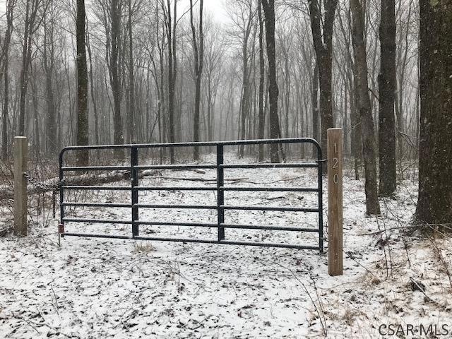
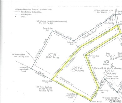
Natural beauty will surround you on this 10 acre level to slightly sloping wooded lot in Steward Twp/Fayette County. Only minutes to Ohio Pyle State Park, Falling Water, Kentuck Knob, Cranberry Lake, and state game lands, the property is close to hunting, fishing, biking, hiking, whitewater, lakes, winter sports, and much more. A nature lover's recreational paradise! Build your dream home, private getaway, hunting cabin, or just use it to camp out under the stars!

NM zzNon-Member

Non-Member Listed on: 06/18/2018

Property Details

Property Type

  • Land

Est. Annual Taxes

  • $2,191

Year Built

  • 2007

Lot Details

  • 10 Acre Lot
  • Gentle Sloping Lot
  • Wooded Lot

Utilities

  • Underground Utilities
  • Cable TV Available

Property Details

Property Type

Land

Est. Annual Taxes

$2,191

Year Built

2007

Lot Details

0

Listing Details

  • Property Sub Type: Unimproved Land
  • Prop. Type: Land
  • Lot Size Acres: 10
  • Lot Size: 718 x 687 x 723 x 245 x 586 x 664
  • Road Frontage Type: Public Street
  • Directions: Rt 31/Glades Pike to 711S to 381E. Follow through Mill Run. Make a left onto Maple Summit Rd. Follow to stop sign, bear left onto Steyer road. Stay left at the Y on to Schroyer . Property is on left.
  • Special Features: None
  • Year Built (Public Record): 2007

Exterior Features

  • Fencing: None
  • Lot Features: Wooded, See Remarks
  • Topography: Level to Sloping
  • Other Structures: None

Utilities

  • Sewer: 10 Acre Exemption, Perc Approved
  • Utilities: None, Cable Available, Underground Utilities, Electricity Available
  • Water Source: None

Condo/Co-op/Association

  • Association Fee Frequency: None
  • Pets Allowed: Yes

Schools

  • Junior High Dist: Uniontown Area School District

Lot Info

  • Lot Size Sq Ft: 435600
  • Farm Land Area Units: Square Feet
  • Zoning Description: Unverified
  • ResoLotSizeUnits: Acres

Multi Family

  • Above Grade Finished Area Units: Square Feet

Tax Info

  • Tax Annual Amount: 85
  • Tax Map Number: 37-04-0010
  • Tax Year: 2018

Range of Values:

Collateral Analytics

Collateral Analytics Collateral Analytics AVMs (Automated Valuation Model) employ a number of statistical approaches combined with neighborhood-specific comparable selection guarantees the most up-to-date and precise valuations.

Not Available

Collateral Analytics does not have data for the current month. Please view the chart for historical values.

ICE

ICE Mortgage Technology ICE Mortgage Technology’s AVM (Automated Valuation Model) is a state-of-the-art online residential property valuation tool that provides a quick and accurate estimate of the value of almost any home in the U.S.

Not Available

ICE Mortgage Technology does not have data for the current month. Please view the chart for historical values.

First American

First American First American Data & Analytics’ next-generation AVM combines unrivaled data assets with a blended ensemble of valuation models to produce highly accurate, reliable valuations you can trust.

Not Available

First American does not have data for the current month. Please view the chart for historical values.

Quantarium

Quantarium Quantarium’s valuation service, repeatedly proven the industry’s most accurate and comprehensive, is supercharged with a self-learning and auto-tuning AI engine that continually becomes smarter and more accurate as it processes daily inputs from the industry’s leading RE data lake.

Not Available

Quantarium does not have data for the current month. Please view the chart for historical values.

Average Value
Not Available
List Price
Sold Price
Create a Home Valuation Report for This Property
The Home Valuation Report is an in-depth analysis detailing your home's value as well as a comparison with similar homes in the area

Home Values in the Area

Source: Public Records

Average Home Value in this Area


Source: Public Records

Mortgage History

Date Status Borrower Loan Amount
Closed Greenbaum James $121,000
Closed Greenbaum Kim $53,000
Source: Public Records

Property History

Date Event Price Change Sq Ft Price
08/28/2019 08/28/19 Sold $55,000 -15.4% --
08/09/2019 08/09/19 Pending -- -- --
06/21/2018 06/21/18 For Sale $65,000 +30.0% --
05/17/2013 05/17/13 Sold $50,000 -16.5% --
04/22/2013 04/22/13 Pending -- -- --
10/23/2012 10/23/12 For Sale $59,900 -- --
Source: Cambria Somerset Association of REALTORS®

Tax History Compared to Growth

Source: Public Records

Tax History

Year Tax Paid Tax Assessment Tax Assessment Total Assessment is a certain percentage of the fair market value that is determined by local assessors to be the total taxable value of land and additions on the property. Land Improvement
2024 $2,191 $89,775 $17,850 $71,925
2023 $4,382 $89,775 $17,850 $71,925
2022 $4,382 $89,775 $17,850 $71,925
2021 $4,382 $89,775 $17,850 $71,925
2020 $4,281 $89,775 $17,850 $71,925
2019 $3,971 $89,775 $17,850 $71,925
2018 $3,761 $89,775 $17,850 $71,925
2017 $3,761 $89,775 $17,850 $71,925
2016 -- $89,775 $17,850 $71,925
2015 -- $89,775 $17,850 $71,925
2014 -- $179,550 $35,700 $143,850
Source: Public Records

Agents Affiliated with this Home

  • Section Image
See All Agents

Map

Source: Cambria Somerset Association of REALTORS®

MLS Number: 96018548

APN: 37-04-0010-03