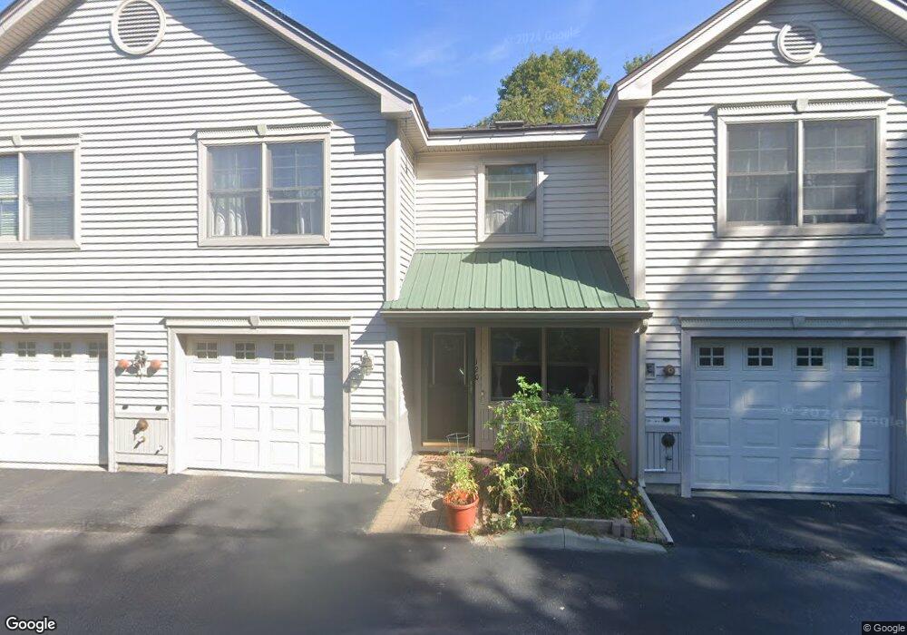
120 Starbird Rd Portland, ME 04102
Nasons Corner NeighborhoodEstimated Value: $456,000 - $774,000
3
Beds
3
Baths
2,612
Sq Ft
$242/Sq Ft
Est. Value
About This Home
This home is located at 120 Starbird Rd, Portland, ME 04102 and is currently estimated at $631,918, approximately $241 per square foot. 120 Starbird Rd is a home located in Cumberland County with nearby schools including Amanda C Rowe School, Lincoln Middle School, and Breakwater School.
Ownership History
Date
Name
Owned For
Owner Type
Purchase Details
Closed on
May 20, 2016
Sold by
Smaha David
Bought by
Mcmullin Zsofia and Mcmullin Andrew
Current Estimated Value
Home Financials for this Owner
Home Financials are based on the most recent Mortgage that was taken out on this home.
Original Mortgage
$270,000
Outstanding Balance
$214,447
Interest Rate
3.59%
Mortgage Type
New Conventional
Estimated Equity
$417,471
Purchase Details
Closed on
Aug 7, 2015
Sold by
Wells Fargo Bank Na Tr
Bought by
Smaha David
Purchase Details
Closed on
Apr 2, 2015
Sold by
Wells Fargo Bank Na Tr
Bought by
Wells Fargo Bank Na Tr
Purchase Details
Closed on
Nov 13, 2006
Sold by
Brown Dev Corp
Bought by
Yates Joan E
Home Financials for this Owner
Home Financials are based on the most recent Mortgage that was taken out on this home.
Original Mortgage
$255,920
Interest Rate
10%
Mortgage Type
Adjustable Rate Mortgage/ARM
Create a Home Valuation Report for This Property
The Home Valuation Report is an in-depth analysis detailing your home's value as well as a comparison with similar homes in the area
Home Values in the Area
Average Home Value in this Area
Purchase History
| Date | Buyer | Sale Price | Title Company |
|---|---|---|---|
| Mcmullin Zsofia | -- | -- | |
| Smaha David | -- | -- | |
| Wells Fargo Bank Na Tr | -- | -- | |
| Yates Joan E | -- | -- |
Source: Public Records
Mortgage History
| Date | Status | Borrower | Loan Amount |
|---|---|---|---|
| Open | Mcmullin Zsofia | $270,000 | |
| Previous Owner | Yates Joan E | $255,920 |
Source: Public Records
Tax History
| Year | Tax Paid | Tax Assessment Tax Assessment Total Assessment is a certain percentage of the fair market value that is determined by local assessors to be the total taxable value of land and additions on the property. | Land | Improvement |
|---|---|---|---|---|
| 2024 | $5,480 | $365,100 | $73,020 | $292,080 |
| 2023 | $5,261 | $365,100 | $73,020 | $292,080 |
| 2022 | $4,969 | $365,100 | $73,020 | $292,080 |
| 2021 | $4,743 | $365,100 | $73,020 | $292,080 |
| 2020 | $6,249 | $268,100 | $53,600 | $214,500 |
| 2019 | $6,249 | $268,100 | $53,600 | $214,500 |
| 2018 | $6,027 | $268,100 | $53,600 | $214,500 |
| 2017 | $5,804 | $268,100 | $53,600 | $214,500 |
| 2016 | $5,660 | $268,100 | $53,600 | $214,500 |
| 2015 | $5,531 | $268,100 | $53,600 | $214,500 |
| 2014 | $5,362 | $268,100 | $53,600 | $214,500 |
Source: Public Records
Map
Nearby Homes
- 100 Starbird Rd Unit 3
- 10 Meadowbrook Ln
- 117 Colonial Rd
- 805 Brighton Ave
- 36 Colonial Rd
- 0 Hillcrest Ave
- 40 Kenilworth St
- 63 Capisic St Unit B
- 79 Frost St
- 499 Brighton Ave
- 1346 Westbrook St
- 49 Montrose Ave
- 50 Eastfield Rd
- 15 Rudman Rd
- 103 Madeline St
- 71 Candlewyck Terrace
- 30 Black Sparrow Dr
- 2 Firefly St Unit 303
- 1 Firefly St Unit 402
- 1 Firefly St Unit 201
- 120 Starbird Rd Unit 11
- 118 Starbird Rd
- 118 Starbird Rd Unit 118
- 118 Starbird Rd Unit 10
- 122 Starbird Rd
- 114 Starbird Rd
- 112 Starbird Rd
- 112 Starbird Rd Unit 8
- 110 Starbird Rd
- 110 Starbird Rd Unit 110
- 110 Starbird Rd Unit 7
- 98 Starbird Rd
- 98 Starbird Rd Unit 2
- 106 Starbird Rd
- 294 Capisic St
- 300 Capisic St
- 104 Starbird Rd
- 104 Starbird Rd Unit 104
- 104 Starbird Rd Unit 5
- 290 Capisic St
Your Personal Tour Guide
Ask me questions while you tour the home.