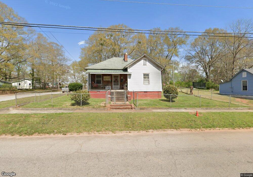
1201 Troup St Lagrange, GA 30240
Estimated Value: $58,000 - $133,000
2
Beds
1
Bath
1,223
Sq Ft
$79/Sq Ft
Est. Value
About This Home
This home is located at 1201 Troup St, Lagrange, GA 30240 and is currently estimated at $96,824, approximately $79 per square foot. 1201 Troup St is a home located in Troup County with nearby schools including Berta Weathersbee Elementary School, Whitesville Road Elementary School, and Rosemont Elementary School.
Ownership History
Date
Name
Owned For
Owner Type
Purchase Details
Closed on
Feb 17, 2006
Sold by
Williamson Elaine
Bought by
Williamson Elaine
Current Estimated Value
Purchase Details
Closed on
May 6, 2004
Sold by
Mary L Brown Etal
Bought by
Williamson Elaine Heir Of Will
Purchase Details
Closed on
Sep 13, 2000
Sold by
Langford Carrie B
Bought by
Mary L Brown Etal
Purchase Details
Closed on
Jan 1, 1987
Bought by
Langford Carrie B
Purchase Details
Closed on
Nov 1, 1969
Create a Home Valuation Report for This Property
The Home Valuation Report is an in-depth analysis detailing your home's value as well as a comparison with similar homes in the area
Purchase History
We collect this data history from publicly available records. To have your information removed, we recommend requesting removal directly through your county’s website.
| Date | Buyer | Sale Price | Title Company |
|---|---|---|---|
| Williamson Elaine | -- | -- | |
| Williamson Elaine | -- | -- | |
| Williamson Elaine Heir Of Will | $14,500 | -- | |
| Mary L Brown Etal | -- | -- | |
| Langford Carrie B | -- | -- | |
| -- | $4,600 | -- |
Source: Public Records
Tax History
| Year | Tax Paid | Tax Assessment Tax Assessment Total Assessment is a certain percentage of the fair market value that is determined by local assessors to be the total taxable value of land and additions on the property. | Land | Improvement |
|---|---|---|---|---|
| 2025 | $630 | $26,236 | $2,720 | $23,516 |
| 2024 | $573 | $22,996 | $2,720 | $20,276 |
| 2023 | $30 | $20,996 | $2,720 | $18,276 |
| 2022 | $491 | $19,596 | $2,720 | $16,876 |
| 2021 | $371 | $14,292 | $2,720 | $11,572 |
| 2020 | $371 | $14,292 | $2,720 | $11,572 |
| 2019 | $268 | $10,876 | $2,280 | $8,596 |
| 2018 | $245 | $10,124 | $2,448 | $7,676 |
| 2017 | $245 | $10,124 | $2,448 | $7,676 |
| 2016 | $236 | $9,819 | $2,448 | $7,371 |
| 2015 | $190 | $8,264 | $2,296 | $5,968 |
| 2014 | $190 | $8,264 | $2,296 | $5,968 |
| 2013 | -- | $8,264 | $2,296 | $5,968 |
Source: Public Records
Map
Nearby Homes
- 1015 Stonewall St
- 1017 Stonewall St
- 1402 Forrest Ave
- 205 Grady St
- 799 Hunnicutt St
- 797 Hunnicutt St
- 900 B N Pkwy
- 1308 Park Ave
- 109 Garfield St
- 9 Crown St Unit LOT 4
- 3 Crown St Unit LOT 1
- 613 S Lee St
- 802 Monroe St
- 1205 Park Ave
- 606 S Lee St
- 202 Parker Ln
- 1300 Murphy Ave
- 517 Jefferson St
- 606 Poplar St
- 519 Freeman St
Your Personal Tour Guide
Ask me questions while you tour the home.