
Seller's Agent in 2025
Tenesha Giles
Real Estate Gurus Realty
(561) 537-9867
5 in this area
32 Total Sales
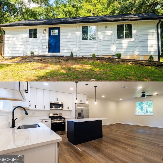
Come explore this fully renovated Stone Mountain beauty-a perfect blend of comfort, style, and modern updates. This 3-bedroom, 2-bathroom ranch offers 1,176 square feet of bright, open living space with brand-new energy-efficient windows and luxury vinyl plank flooring throughout. The designer kitchen features new cabinetry, quartz countertops, stainless steel appliances, and a center island ideal for everyday meals or entertaining. The spacious primary suite includes a walk-in closet and a private en-suite with a tiled shower surround, while both bathrooms feature sleek finishes and updated tile flooring. A private driveway and a backyard bordered by fencing on multiple sides provide space to relax or entertain. Conveniently located near Hwy 78, parks, schools, and shopping, this move-in ready home is waiting for its next owner. ***INQUIRE ABOUT DOWN PAYMENT ASSISTANCE AVAILABLE FOR THIS HOME***
Last Agent to Sell the Property
Real Estate Gurus Realty License #382156 Listed on: 07/31/2025
Last Buyer's Agent
No Sales Agent
Non-Mls Company License #0
| Date | Type | Sale Price | Title Company |
|---|---|---|---|
| Limited Warranty Deed | $210,000 | -- | |
| Administrators Deed | $70,000 | -- | |
| Deed | $54,900 | -- |
| Date | Status | Loan Amount | Loan Type |
|---|---|---|---|
| Open | $203,500 | FHA | |
| Previous Owner | $133,000 | New Conventional | |
| Previous Owner | $53,250 | No Value Available |
| Date | Event | Price | List to Sale | Price per Sq Ft |
|---|---|---|---|---|
| 10/06/2025 10/06/25 | Sold | $234,900 | 0.0% | $200 / Sq Ft |
| 08/20/2025 08/20/25 | Price Changed | $234,900 | -2.1% | $200 / Sq Ft |
| 08/14/2025 08/14/25 | Price Changed | $239,950 | -2.4% | $204 / Sq Ft |
| 07/31/2025 07/31/25 | For Sale | $245,950 | -- | $209 / Sq Ft |
| Year | Tax Paid | Tax Assessment Tax Assessment Total Assessment is a certain percentage of the fair market value that is determined by local assessors to be the total taxable value of land and additions on the property. | Land | Improvement |
|---|---|---|---|---|
| 2025 | $661 | $83,840 | $12,000 | $71,840 |
| 2024 | $691 | $86,360 | $11,200 | $75,160 |
| 2023 | $691 | $88,520 | $12,000 | $76,520 |
| 2022 | $594 | $63,680 | $6,000 | $57,680 |
| 2021 | $594 | $48,240 | $6,000 | $42,240 |
| 2020 | $598 | $47,720 | $6,000 | $41,720 |
| 2019 | $582 | $33,760 | $6,000 | $27,760 |
| 2018 | $585 | $21,320 | $3,880 | $17,440 |
| 2017 | $511 | $25,600 | $3,880 | $21,720 |
| 2016 | $595 | $23,200 | $3,880 | $19,320 |
| 2014 | $434 | $14,800 | $3,880 | $10,920 |
Seller's Agent in 2025
Tenesha Giles
Real Estate Gurus Realty
(561) 537-9867
5 in this area
32 Total Sales
N
Buyer's Agent in 2025
No Sales Agent
Non-Mls Company
Source: Georgia MLS
MLS Number: 10575227
APN: 15-223-01-107
Disclaimer: Certain information contained herein is derived from information provided by parties other than Homes.com. All information provided is deemed reliable, but is not guaranteed to be accurate and should be independently verified.
![]() The data relating to real estate for sale on this web site comes in part from the Broker Reciprocity Program of Georgia MLS. Real estate listings held by brokerage firms other than Redfin are marked with the Broker Reciprocity logo and detailed information about them includes the name of the listing brokers. Information deemed reliable but not guaranteed. Copyright 2026 Georgia MLS. All rights reserved.
The data relating to real estate for sale on this web site comes in part from the Broker Reciprocity Program of Georgia MLS. Real estate listings held by brokerage firms other than Redfin are marked with the Broker Reciprocity logo and detailed information about them includes the name of the listing brokers. Information deemed reliable but not guaranteed. Copyright 2026 Georgia MLS. All rights reserved.
Ask me questions while you tour the home.