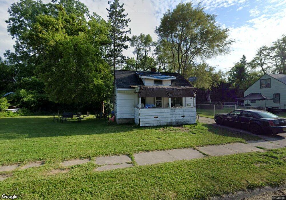
121 E Lorado Ave Flint, MI 48505
MLK Circle NeighborhoodEstimated Value: $19,000 - $56,000
2
Beds
1
Bath
540
Sq Ft
$74/Sq Ft
Est. Value
About This Home
This home is located at 121 E Lorado Ave, Flint, MI 48505 and is currently estimated at $39,865, approximately $73 per square foot. 121 E Lorado Ave is a home located in Genesee County with nearby schools including Brownell STEM Academy, The New Standard Academy, and Eagle's Nest Academy.
Ownership History
Date
Name
Owned For
Owner Type
Purchase Details
Closed on
Feb 8, 2013
Sold by
Genesee County Land Bank Authority
Bought by
Johnson Dennis
Current Estimated Value
Purchase Details
Closed on
Sep 2, 2011
Sold by
The Genesee County Land Bank Authority
Bought by
Johnson Dennis
Purchase Details
Closed on
Feb 15, 2005
Sold by
Gentry Melvin
Bought by
Thomas Kelley
Purchase Details
Closed on
Jul 9, 1999
Sold by
Thomas K
Bought by
Gentry Melvin
Create a Home Valuation Report for This Property
The Home Valuation Report is an in-depth analysis detailing your home's value as well as a comparison with similar homes in the area
Home Values in the Area
Average Home Value in this Area
Purchase History
| Date | Buyer | Sale Price | Title Company |
|---|---|---|---|
| Johnson Dennis | $2,000 | None Available | |
| Johnson Dennis | $2,000 | None Available | |
| Thomas Kelley | -- | -- | |
| Gentry Melvin | -- | Lawyers Title Insurance Co |
Source: Public Records
Mortgage History
| Date | Status | Borrower | Loan Amount |
|---|---|---|---|
| Closed | Johnson Dennis | $0 |
Source: Public Records
Tax History
| Year | Tax Paid | Tax Assessment Tax Assessment Total Assessment is a certain percentage of the fair market value that is determined by local assessors to be the total taxable value of land and additions on the property. | Land | Improvement |
|---|---|---|---|---|
| 2025 | $419 | $4,900 | $0 | $0 |
| 2024 | $399 | $4,200 | $0 | $0 |
| 2023 | $403 | $3,900 | $0 | $0 |
| 2022 | $0 | $2,900 | $0 | $0 |
| 2021 | $406 | $3,000 | $0 | $0 |
| 2020 | $386 | $3,100 | $0 | $0 |
| 2019 | $389 | $2,900 | $0 | $0 |
| 2018 | $345 | $2,400 | $0 | $0 |
| 2017 | $444 | $0 | $0 | $0 |
| 2016 | $443 | $0 | $0 | $0 |
| 2015 | -- | $0 | $0 | $0 |
| 2014 | -- | $0 | $0 | $0 |
| 2012 | -- | $5,900 | $0 | $0 |
Source: Public Records
Map
Nearby Homes
- 225 E Piper Ave
- 246 E York Ave
- 209 E York Ave
- 345 E Austin Ave
- 518 W Ruth Ave
- 405 W Bundy Ave
- 421 E Lorado Ave
- 514 W Alma Ave
- 425 E Lorado Ave
- 422 E Foss Ave
- 605 W Foss Ave
- 426 E Holbrook Ave
- 610 W Austin Ave
- 613 W Foss Ave
- 614 W Holbrook Ave
- 536 W Home Ave
- 638 E Foss Ave
- 6710 Cranwood Dr
- 6714 Cranwood Dr
- 6609 Cranwood Dr
- 113 E Lorado Ave
- 129 E Lorado Ave
- 118 E Foss Ave
- 114 E Foss Ave
- 110 E Foss Ave
- 134 E Foss Ave
- 118 E Lorado Ave
- 126 E Lorado Ave
- 105 E Lorado Ave
- 114 E Lorado Ave
- 130 E Lorado Ave
- 138 E Foss Ave
- 134 E Lorado Ave
- 101 E Lorado Ave
- 102 E Foss Ave
- 138 E Lorado Ave
- 142 E Foss Ave
- 109 E Foss Ave
- 125 E Foss Ave
- 117 E Foss Ave
Your Personal Tour Guide
Ask me questions while you tour the home.