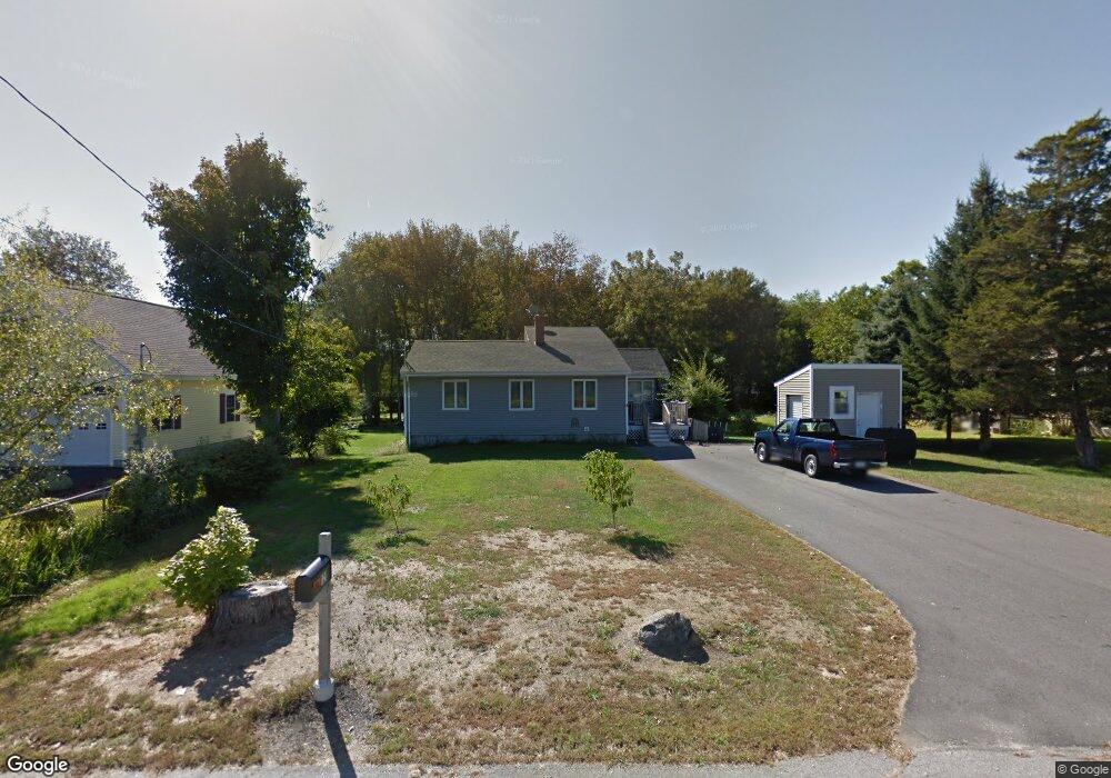
121 Hanscom Rd Eliot, ME 03903
East Eliot NeighborhoodEstimated Value: $417,000 - $477,000
2
Beds
1
Bath
1,032
Sq Ft
$430/Sq Ft
Est. Value
About This Home
This home is located at 121 Hanscom Rd, Eliot, ME 03903 and is currently estimated at $444,256, approximately $430 per square foot. 121 Hanscom Rd is a home located in York County with nearby schools including Marshwood High School and Seacoast Waldorf School.
Ownership History
Date
Name
Owned For
Owner Type
Purchase Details
Closed on
Jul 25, 2022
Sold by
Randolph Steven F
Bought by
Randolph Linda L
Current Estimated Value
Purchase Details
Closed on
Oct 28, 2013
Sold by
Randolph John F and Randolph Josephine
Bought by
Randolph Linda L and Randolph Steven F
Purchase Details
Closed on
Oct 26, 2013
Sold by
Randolph John F and Randolph Steven F
Bought by
Randolph Linda L and Randolph Steven F
Create a Home Valuation Report for This Property
The Home Valuation Report is an in-depth analysis detailing your home's value as well as a comparison with similar homes in the area
Home Values in the Area
Average Home Value in this Area
Purchase History
| Date | Buyer | Sale Price | Title Company |
|---|---|---|---|
| Randolph Linda L | -- | None Available | |
| Randolph Linda L | -- | -- | |
| Randolph Linda L | -- | None Available |
Source: Public Records
Tax History
| Year | Tax Paid | Tax Assessment Tax Assessment Total Assessment is a certain percentage of the fair market value that is determined by local assessors to be the total taxable value of land and additions on the property. | Land | Improvement |
|---|---|---|---|---|
| 2025 | $3,428 | $304,700 | $147,700 | $157,000 |
| 2024 | $3,459 | $291,900 | $134,900 | $157,000 |
| 2023 | $3,250 | $265,300 | $128,500 | $136,800 |
| 2022 | $3,067 | $253,500 | $128,500 | $125,000 |
| 2021 | $2,919 | $240,000 | $117,900 | $122,100 |
| 2020 | $3,152 | $214,400 | $112,500 | $101,900 |
| 2019 | $3,152 | $214,400 | $112,500 | $101,900 |
| 2018 | $2,272 | $214,400 | $112,500 | $101,900 |
| 2017 | $2,334 | $214,400 | $112,500 | $101,900 |
| 2016 | $3,012 | $214,400 | $112,500 | $101,900 |
| 2015 | $3,002 | $214,400 | $112,500 | $101,900 |
| 2014 | $2,926 | $212,000 | $112,500 | $99,500 |
| 2013 | $2,792 | $212,000 | $112,500 | $99,500 |
Source: Public Records
Map
Nearby Homes
- 64 Village Dr Unit 23
- 42 Caslyn Dr
- 223 Bolt Hill Rd
- 19 Aspen Cir
- 9 Roseberry Ln
- 1088 State Rd
- 22 Turkeytail Ln
- 18 Shipping Ln
- 60 Pine Hill Rd S Unit 315
- 60 Pine Hill Rd S Unit 318
- 100 Shepard's Cove Rd Unit H305
- 100 Shepard's Cove Rd Unit G107
- 100 Shepards Cove Rd Unit F204
- 100 Shepards Cove Rd Unit H301
- 53 Blackberry Place
- 333 Main St
- 10 Bayview Ln
- 30-3 Regency Cir Unit 3
- 25 Regency Cir Unit 1
- 8 Grover Ln
Your Personal Tour Guide
Ask me questions while you tour the home.