2
Beds
2
Baths
2,000
Sq Ft
5,009
Sq Ft Lot
About This Home
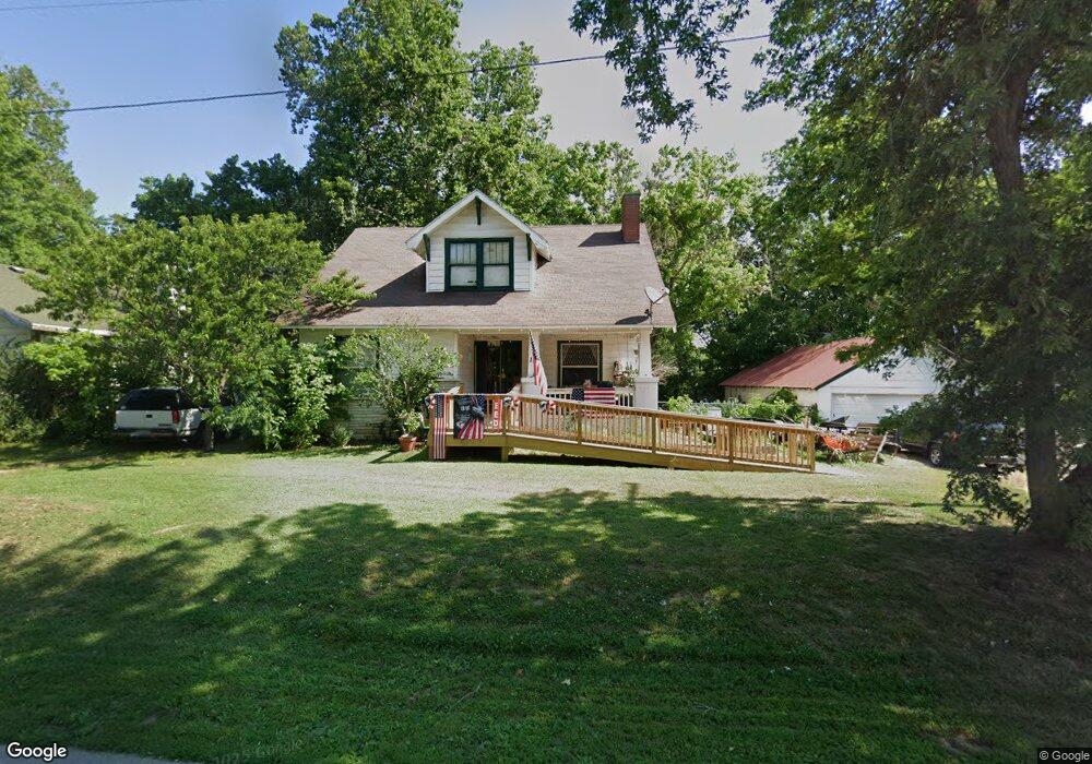
This home is located at 121 W Main St, Crane, MO 65633. 121 W Main St is a home located in Stone County with nearby schools including Hurley Elementary School and Hurley High School.
Ownership History
Date
Name
Owned For
Owner Type
Purchase Details
Closed on
Jul 23, 2012
Sold by
Kaup Michael E
Bought by
Kaup Michael E
Home Financials for this Owner
Home Financials are based on the most recent Mortgage that was taken out on this home.
Original Mortgage
$10,000
Outstanding Balance
$6,894
Interest Rate
3.72%
Mortgage Type
Credit Line Revolving
Purchase Details
Closed on
Apr 27, 2005
Sold by
Bankers Trust Co Of California N A
Bought by
Wolfe Ronald and Wolfe Tracey
Home Financials for this Owner
Home Financials are based on the most recent Mortgage that was taken out on this home.
Original Mortgage
$60,000
Interest Rate
6.03%
Mortgage Type
Future Advance Clause Open End Mortgage
Create a Home Valuation Report for This Property
The Home Valuation Report is an in-depth analysis detailing your home's value as well as a comparison with similar homes in the area
Purchase History
| Date | Buyer | Sale Price | Title Company |
|---|---|---|---|
| Kaup Michael E | -- | None Available | |
| Wolfe Ronald | -- | -- |
Source: Public Records
Mortgage History
| Date | Status | Borrower | Loan Amount |
|---|---|---|---|
| Open | Kaup Michael E | $10,000 | |
| Previous Owner | Wolfe Ronald | $60,000 |
Source: Public Records
Tax History
| Year | Tax Paid | Tax Assessment Tax Assessment Total Assessment is a certain percentage of the fair market value that is determined by local assessors to be the total taxable value of land and additions on the property. | Land | Improvement |
|---|---|---|---|---|
| 2025 | $339 | $6,530 | -- | -- |
| 2024 | $339 | $6,530 | -- | -- |
| 2023 | $339 | $6,530 | $0 | $0 |
| 2022 | $337 | $6,530 | $0 | $0 |
| 2021 | $341 | $6,530 | $0 | $0 |
| 2020 | $339 | $6,530 | $0 | $0 |
| 2019 | $339 | $6,530 | $0 | $0 |
| 2018 | $339 | $6,530 | $0 | $0 |
| 2017 | $338 | $6,530 | $0 | $0 |
| 2016 | $331 | $6,530 | $0 | $0 |
| 2015 | $334 | $6,530 | $0 | $0 |
| 2014 | $335 | $6,590 | $0 | $0 |
| 2012 | $310 | $6,590 | $0 | $0 |
Source: Public Records
Map
Nearby Homes
- 300 Lane Branch Rd
- 1526 Ozark Rd
- 745 Pardon Rd
- 127 Woods Edge Rd
- 73 Gamble Rd
- 443 Marsha Rd
- 12024 State Highway M
- 000 Highway M
- 1601 State Highway B
- 12754 State Highway M
- 000 Rodeo Ln
- 30 Southern Cross Dr
- 107 E Mockingbird Ln
- 305 E Maud Ave
- 504 E Park Ave
- 502 Myrtle St
- 311 College St
- 615 Main St
- 000 Pine St
- 000 College St
- 103 W Main St
- 104 S Walnut St
- 105 Sims St
- 109 S Walnut St
- 107 Kelly St
- 107 Kelly St
- 105 Kelly St
- 203 S Walnut St
- 204 Main St
- 204 Main St
- 0 W Hwy A Unit 10619373
- 0 W Hwy A Unit 10914431
- 000 Town Block All 9
- Hwy K Missouri A
- 100 Lane Branch Rd
- 219 W Main St
- 223 W Main St
- 111 Lane Branch Rd
- 109 Davis St
- 339 S Walnut St
Your Personal Tour Guide
Ask me questions while you tour the home.