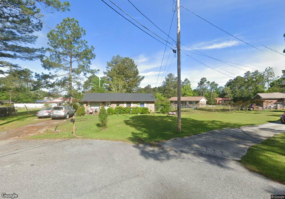
1211 Maple St Moultrie, GA 31768
Estimated Value: $82,146 - $92,000
Studio
1
Bath
1,075
Sq Ft
$80/Sq Ft
Est. Value
About This Home
This home is located at 1211 Maple St, Moultrie, GA 31768 and is currently estimated at $85,537, approximately $79 per square foot. 1211 Maple St is a home located in Colquitt County with nearby schools including C.A. Gray Junior High School, Willie J. Williams Middle School, and Colquitt County High School.
Ownership History
Date
Name
Owned For
Owner Type
Purchase Details
Closed on
Nov 23, 2009
Sold by
Ndawula Myrtis Mulkey
Bought by
The Willis His Llc
Current Estimated Value
Home Financials for this Owner
Home Financials are based on the most recent Mortgage that was taken out on this home.
Original Mortgage
$19,500
Interest Rate
7%
Mortgage Type
Future Advance Clause Open End Mortgage
Create a Home Valuation Report for This Property
The Home Valuation Report is an in-depth analysis detailing your home's value as well as a comparison with similar homes in the area
Purchase History
We collect this data history from publicly available records. To have your information removed, we recommend requesting removal directly through your county’s website.
| Date | Buyer | Sale Price | Title Company |
|---|---|---|---|
| The Willis His Llc | $26,000 | -- |
Source: Public Records
Mortgage History
We collect this data history from publicly available records. To have your information removed, we recommend requesting removal directly through your county’s website.
| Date | Status | Borrower | Loan Amount |
|---|---|---|---|
| Closed | The Willis His Llc | $19,500 |
Source: Public Records
Tax History
| Year | Tax Paid | Tax Assessment Tax Assessment Total Assessment is a certain percentage of the fair market value that is determined by local assessors to be the total taxable value of land and additions on the property. | Land | Improvement |
|---|---|---|---|---|
| 2025 | $458 | $15,900 | $1,600 | $14,300 |
| 2024 | $458 | $17,006 | $1,600 | $15,406 |
| 2023 | $513 | $19,059 | $1,600 | $17,459 |
| 2022 | $539 | $16,094 | $1,600 | $14,494 |
| 2021 | $545 | $16,080 | $1,600 | $14,480 |
| 2020 | $555 | $16,080 | $1,600 | $14,480 |
| 2019 | $624 | $16,080 | $1,600 | $14,480 |
| 2018 | $642 | $16,080 | $1,600 | $14,480 |
| 2017 | $617 | $16,080 | $1,600 | $14,480 |
| 2016 | $642 | $16,080 | $1,600 | $14,480 |
| 2015 | $644 | $16,080 | $1,600 | $14,480 |
| 2014 | $660 | $16,080 | $1,600 | $14,480 |
| 2013 | -- | $16,080 | $1,600 | $14,480 |
Source: Public Records
Map
Nearby Homes
- 1021 11th Ave NW
- 1433 Old Doerun Rd
- 00 N Main St
- 316 5th Ave NW
- 521 5th Ave NW
- 0 Old Doerun Rd Unit 10770070
- 408 9th St NW
- 323 2nd St NW
- 324 3rd Ave NW
- LOT 19 10th St NW
- 0 S U Highway 319 N
- 610 1st Ave NW
- 518 1st Ave SW Unit 3
- 310 1st Ave SW
- 0 Pheasant Ln Unit 915769
- 200 8th St SW
- 614 3rd Ave SW
- 616 3rd Ave SW
- 221 6th St SW
- 107 30th Ave NW
Your Personal Tour Guide
Ask me questions while you tour the home.