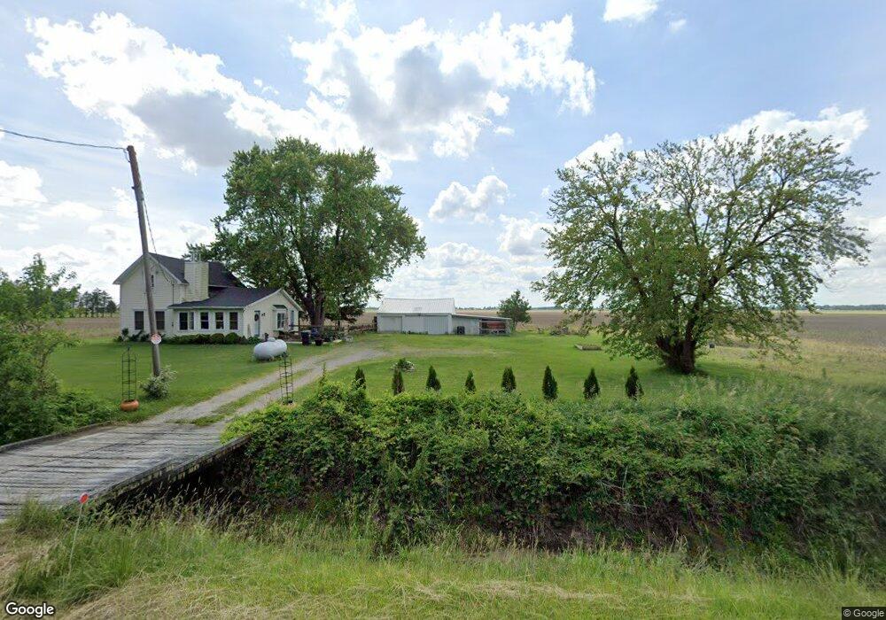
12113 Range Line Rd Weston, OH 43569
Estimated Value: $167,000 - $194,000
3
Beds
2
Baths
1,290
Sq Ft
$139/Sq Ft
Est. Value
About This Home
This home is located at 12113 Range Line Rd, Weston, OH 43569 and is currently estimated at $178,779, approximately $138 per square foot. 12113 Range Line Rd is a home located in Wood County with nearby schools including Otsego Elementary School, Otsego Junior High School, and Otsego High School.
Ownership History
Date
Name
Owned For
Owner Type
Purchase Details
Closed on
Sep 6, 2019
Sold by
Mazey Kurt R and Mazey Michelle E
Bought by
Rinearson Jared L and Hill Jolene D
Current Estimated Value
Home Financials for this Owner
Home Financials are based on the most recent Mortgage that was taken out on this home.
Original Mortgage
$123,750
Outstanding Balance
$107,436
Interest Rate
3.7%
Mortgage Type
New Conventional
Estimated Equity
$71,343
Purchase Details
Closed on
Nov 2, 1999
Sold by
Heyman Dalette A and Conrad Dalette A
Bought by
Mazey Kurt R and Mazey Michelle E
Home Financials for this Owner
Home Financials are based on the most recent Mortgage that was taken out on this home.
Original Mortgage
$75,000
Interest Rate
7.87%
Purchase Details
Closed on
Nov 3, 1989
Bought by
Heyman Philip
Create a Home Valuation Report for This Property
The Home Valuation Report is an in-depth analysis detailing your home's value as well as a comparison with similar homes in the area
Purchase History
| Date | Buyer | Sale Price | Title Company |
|---|---|---|---|
| Rinearson Jared L | $137,500 | None Available | |
| Mazey Kurt R | $75,000 | -- | |
| Heyman Philip | -- | -- |
Source: Public Records
Mortgage History
| Date | Status | Borrower | Loan Amount |
|---|---|---|---|
| Open | Rinearson Jared L | $123,750 | |
| Closed | Mazey Kurt R | $75,000 |
Source: Public Records
Tax History
| Year | Tax Paid | Tax Assessment Tax Assessment Total Assessment is a certain percentage of the fair market value that is determined by local assessors to be the total taxable value of land and additions on the property. | Land | Improvement |
|---|---|---|---|---|
| 2025 | $1,742 | $47,110 | $6,580 | $40,530 |
| 2024 | $1,767 | $47,110 | $6,580 | $40,530 |
| 2023 | $1,767 | $47,110 | $6,580 | $40,530 |
| 2021 | $1,616 | $38,850 | $5,250 | $33,600 |
| 2020 | $1,567 | $38,850 | $5,250 | $33,600 |
| 2019 | $1,067 | $25,900 | $5,250 | $20,650 |
| 2018 | $1,066 | $25,900 | $5,250 | $20,650 |
| 2017 | $963 | $25,900 | $5,250 | $20,650 |
| 2016 | $831 | $21,360 | $3,960 | $17,400 |
| 2015 | $831 | $21,360 | $3,960 | $17,400 |
| 2014 | $871 | $21,360 | $3,960 | $17,400 |
| 2013 | $980 | $21,360 | $3,960 | $17,400 |
Source: Public Records
Map
Nearby Homes
- 20175 Taylor St
- 0 Sand Ridge Rd Unit 10004038
- 20280 Locust St
- 13439 Ash St
- 17884 Euler Rd
- 21490 Portage Rd
- 16313 Euler Rd
- 14590 Liberty Hi Rd
- 916 Kathy Dr
- 22487 U S 6
- 1738 Dolly Dr
- 1742 Dolly Dr
- 838 Dolly Dr
- 0 Mitchell Rd S Unit 225038099
- 1615 Gleneagles Dr
- 930 Pine Valley Dr
- 1631 Winterwood Ct
- 924 Pine Valley Dr
- 896 Pine Valley Dr
- 884 Pine Valley Dr
Your Personal Tour Guide
Ask me questions while you tour the home.