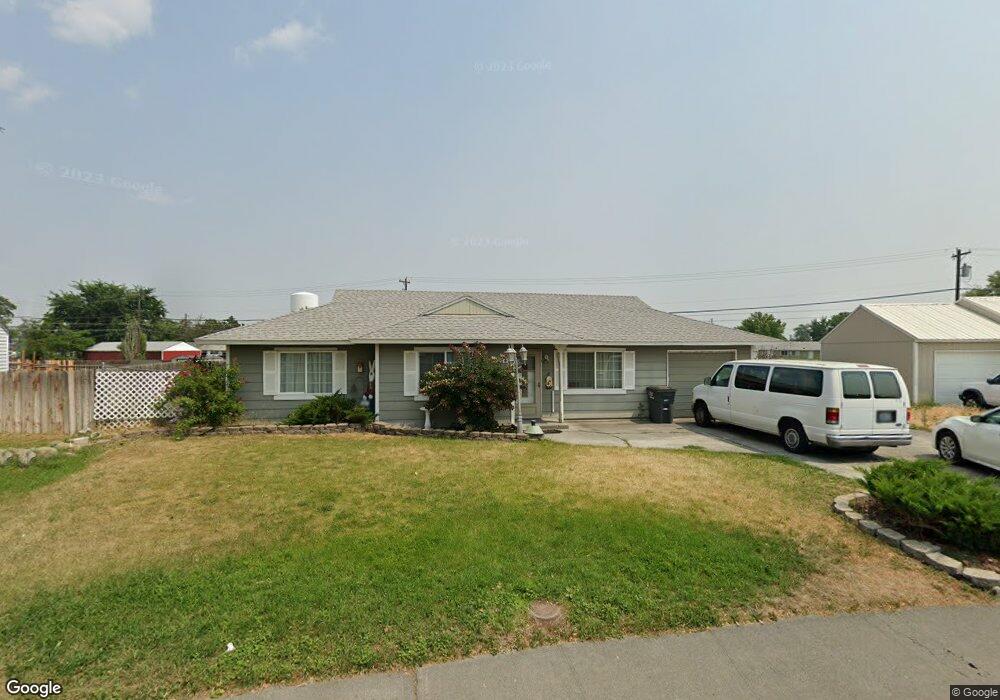
1214 Pershing Rd Moses Lake, WA 98837
Estimated Value: $220,729 - $248,000
3
Beds
1
Bath
1,364
Sq Ft
$173/Sq Ft
Est. Value
About This Home
This home is located at 1214 Pershing Rd, Moses Lake, WA 98837 and is currently estimated at $235,682, approximately $172 per square foot. 1214 Pershing Rd is a home located in Grant County with nearby schools including North Elementary School, Endeavor Middle School, and Moses Lake High School.
Ownership History
Date
Name
Owned For
Owner Type
Purchase Details
Closed on
Sep 17, 2007
Sold by
Patten John R and Patten Cynthia A
Bought by
Epperson Victoria
Current Estimated Value
Home Financials for this Owner
Home Financials are based on the most recent Mortgage that was taken out on this home.
Original Mortgage
$35,000
Outstanding Balance
$5,598
Interest Rate
6.42%
Mortgage Type
Seller Take Back
Estimated Equity
$230,084
Create a Home Valuation Report for This Property
The Home Valuation Report is an in-depth analysis detailing your home's value as well as a comparison with similar homes in the area
Home Values in the Area
Average Home Value in this Area
Purchase History
| Date | Buyer | Sale Price | Title Company |
|---|---|---|---|
| Epperson Victoria | $105,000 | Security Title Guaranty |
Source: Public Records
Mortgage History
| Date | Status | Borrower | Loan Amount |
|---|---|---|---|
| Open | Epperson Victoria | $35,000 |
Source: Public Records
Tax History
| Year | Tax Paid | Tax Assessment Tax Assessment Total Assessment is a certain percentage of the fair market value that is determined by local assessors to be the total taxable value of land and additions on the property. | Land | Improvement |
|---|---|---|---|---|
| 2025 | $361 | $89,110 | -- | -- |
| 2024 | $360 | $169,014 | $28,500 | $140,514 |
| 2023 | $370 | $142,725 | $28,500 | $114,225 |
| 2022 | $374 | $142,725 | $28,500 | $114,225 |
| 2021 | $379 | $142,725 | $28,500 | $114,225 |
| 2020 | $381 | $119,045 | $28,500 | $90,545 |
| 2019 | $370 | $90,655 | $20,000 | $70,655 |
| 2018 | $368 | $87,595 | $20,000 | $67,595 |
| 2017 | $335 | $97,735 | $20,000 | $77,735 |
| 2016 | $247 | $79,790 | $20,000 | $59,790 |
| 2013 | -- | $74,355 | $20,000 | $54,355 |
Source: Public Records
Map
Nearby Homes
- 1314 Pershing Rd
- 1316 Pershing Rd
- 1215 Lowry St
- 9035 Forrestal Ln
- 9008 Bong Loop Unit B
- 9021 Mcconnell Dr Unit A
- 9023 Mcconnell Dr Unit A
- 9016 Bong Loop Unit A
- 0 Nna I Rd NE Unit NWM2484402
- 206 208 Beale Ave
- 537 Fairchild Loop
- 205 March Dr NE
- 533 Fairchild Loop
- 4898 Shorecrest Dr NE
- 8521 Jean Rd NE
- 4815 Airway Dr NE Unit 128
- 4815 Airway Dr NE Unit 72
- 4815 Airway Dr NE Unit 81
- 0 NNA Road I NE
- 4492 Jackie Dr NE
- 1212 Pershing Rd
- 1216 1218 Pershing Rd
- 1216 Pershing Rd
- 1218 Pershing Rd
- 1210 Pershing Rd
- 1213 Pershing Rd
- 1208 1210 Pershing Rd
- 1208 Pershing Rd
- 1209 Pershing Rd
- 1220 Pershing Rd
- 1219 Pershing Rd
- 1208 Arlington Dr
- 1210 Arlington Dr
- 1206 Pershing Rd
- 1225 Pershing Rd
- 906 Lowry St
- 1224 Pershing Rd
- 920 Doolittle Ln
- 1222 -1224 Pershing Rd
- 1222 1224 Pershing Rd
Your Personal Tour Guide
Ask me questions while you tour the home.