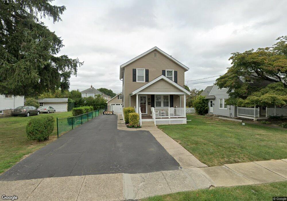
122 E Roland Rd Brookhaven, PA 19015
Estimated Value: $294,000 - $302,000
3
Beds
2
Baths
1,452
Sq Ft
$206/Sq Ft
Est. Value
About This Home
This home is located at 122 E Roland Rd, Brookhaven, PA 19015 and is currently estimated at $299,131, approximately $206 per square foot. 122 E Roland Rd is a home located in Delaware County with nearby schools including Widener Partnership Charter School, Drexel Newman Academy, and The Christian Academy.
Ownership History
Date
Name
Owned For
Owner Type
Purchase Details
Closed on
Jul 15, 2005
Sold by
Gasiorowski Gina
Bought by
Alshon Mark J and Gonzalez Carolina
Current Estimated Value
Home Financials for this Owner
Home Financials are based on the most recent Mortgage that was taken out on this home.
Original Mortgage
$158,746
Outstanding Balance
$82,492
Interest Rate
5.59%
Mortgage Type
FHA
Estimated Equity
$216,639
Create a Home Valuation Report for This Property
The Home Valuation Report is an in-depth analysis detailing your home's value as well as a comparison with similar homes in the area
Home Values in the Area
Average Home Value in this Area
Purchase History
We collect this data history from publicly available records. To have your information removed, we recommend requesting removal directly through your county’s website.
| Date | Buyer | Sale Price | Title Company |
|---|---|---|---|
| Alshon Mark J | $160,000 | T A Title Insurance Company |
Source: Public Records
Mortgage History
We collect this data history from publicly available records. To have your information removed, we recommend requesting removal directly through your county’s website.
| Date | Status | Borrower | Loan Amount |
|---|---|---|---|
| Open | Alshon Mark J | $158,746 |
Source: Public Records
Tax History
| Year | Tax Paid | Tax Assessment Tax Assessment Total Assessment is a certain percentage of the fair market value that is determined by local assessors to be the total taxable value of land and additions on the property. | Land | Improvement |
|---|---|---|---|---|
| 2025 | $5,063 | $157,370 | $37,900 | $119,470 |
| 2024 | $5,063 | $157,370 | $37,900 | $119,470 |
| 2023 | $4,742 | $157,370 | $37,900 | $119,470 |
| 2022 | $4,479 | $157,370 | $37,900 | $119,470 |
| 2021 | $6,457 | $157,370 | $37,900 | $119,470 |
| 2020 | $3,888 | $83,360 | $29,360 | $54,000 |
| 2019 | $3,823 | $83,360 | $29,360 | $54,000 |
| 2018 | $3,764 | $83,360 | $0 | $0 |
| 2017 | $3,571 | $83,360 | $0 | $0 |
| 2016 | $457 | $83,360 | $0 | $0 |
| 2015 | $457 | $83,360 | $0 | $0 |
| 2014 | $457 | $83,360 | $0 | $0 |
Source: Public Records
Map
Nearby Homes
- 204 E Avon Rd
- 125 E Avon Rd
- 114 E Parkway Ave
- 122 Roberts Rd
- 97 Park Vallei Ln
- 96 Park Vallei Ln
- 119B Meadowbrook Ln
- 3228 Tom Sweeney Dr
- 30 W Avon Rd
- 157 Meadowbrook Ln
- 112 Upland Rd
- 17 E Mowry St
- 209 W Forestview Rd
- 123 Ridley Dr
- 3608 Williamson Ave
- 3408 Washington Ave
- 17 Ridley Dr
- 43 E 24th St
- 1160 Putnam Blvd Unit 71
- 240 Upland Rd
- 140 E Roland Rd
- 142 E Roland Rd
- 136 E Roland Rd
- 144 E Roland Rd
- 132 E Roland Rd
- 51 E Chelton Rd
- 53 E Chelton Rd
- 49 E Chelton Rd
- 180 E Roland Rd
- 55 E Chelton Rd
- 0 E Roland Rd
- 130 E Roland Rd
- 47 E Chelton Rd
- 141 E Roland Rd
- 137 E Roland Rd
- 143 E Roland Rd
- 57 E Chelton Rd
- 135 E Roland Rd
- 43 E Chelton Rd
- 145 E Roland Rd
Your Personal Tour Guide
Ask me questions while you tour the home.