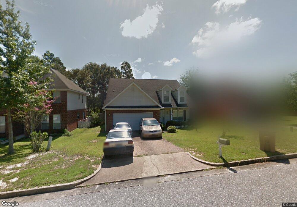
1221 Smithfield Rd E Mobile, AL 36695
Sheldon NeighborhoodEstimated Value: $234,000 - $279,536
4
Beds
3
Baths
2,312
Sq Ft
$114/Sq Ft
Est. Value
About This Home
This home is located at 1221 Smithfield Rd E, Mobile, AL 36695 and is currently estimated at $264,134, approximately $114 per square foot. 1221 Smithfield Rd E is a home located in Mobile County with nearby schools including ER Dickson Elementary School, Burns Middle School, and WP Davidson High School.
Ownership History
Date
Name
Owned For
Owner Type
Purchase Details
Closed on
Apr 7, 2005
Sold by
Fletcher Delmar G
Bought by
Fletcher Rosa L
Current Estimated Value
Purchase Details
Closed on
Nov 26, 1997
Sold by
Mitchell Company Inc The
Bought by
Fletcher Delmar G and Fletcher Rosa L
Home Financials for this Owner
Home Financials are based on the most recent Mortgage that was taken out on this home.
Original Mortgage
$135,900
Interest Rate
7.95%
Create a Home Valuation Report for This Property
The Home Valuation Report is an in-depth analysis detailing your home's value as well as a comparison with similar homes in the area
Home Values in the Area
Average Home Value in this Area
Purchase History
We collect this data history from publicly available records. To have your information removed, we recommend requesting removal directly through your county’s website.
| Date | Buyer | Sale Price | Title Company |
|---|---|---|---|
| Fletcher Rosa L | $14,196 | -- | |
| Fletcher Delmar G | -- | -- |
Source: Public Records
Mortgage History
We collect this data history from publicly available records. To have your information removed, we recommend requesting removal directly through your county’s website.
| Date | Status | Borrower | Loan Amount |
|---|---|---|---|
| Previous Owner | Fletcher Delmar G | $135,900 |
Source: Public Records
Tax History
| Year | Tax Paid | Tax Assessment Tax Assessment Total Assessment is a certain percentage of the fair market value that is determined by local assessors to be the total taxable value of land and additions on the property. | Land | Improvement |
|---|---|---|---|---|
| 2025 | -- | $17,190 | $2,800 | $14,390 |
| 2024 | -- | $17,390 | $2,800 | $14,590 |
| 2023 | $745 | $16,360 | $2,800 | $13,560 |
| 2022 | $735 | $16,540 | $2,800 | $13,740 |
| 2021 | $1,006 | $16,900 | $2,800 | $14,100 |
| 2020 | $1,011 | $16,980 | $2,800 | $14,180 |
| 2019 | $1,010 | $16,960 | $0 | $0 |
| 2018 | $1,038 | $17,400 | $0 | $0 |
| 2017 | $1,039 | $17,420 | $0 | $0 |
| 2016 | $1,061 | $17,760 | $0 | $0 |
| 2013 | $809 | $17,740 | $0 | $0 |
Source: Public Records
Map
Nearby Homes
- 1263 Smithfield Rd E
- 7086 Crown Pointe Dr
- 7160 Windmill Place N
- 6939 Johnston Ln
- 1130 Jonathan Ct
- 1361 Dellwyn Ct
- 7243 Bull Pen Cir
- 6701 Somerby Ln
- 6617 Somerby Ln
- 6716 Somerby Ln
- 6605 Somerby Ln
- 7315 Bridgewood Ct
- 1285 Carson Rd E
- 7225 Hawkins Manor
- 1104 Hanging Lantern Cir
- 7220 Hawkins Manor
- 6832 Somerby Ln
- 7382 Hawkins Manor
- 7237 Hawkins Manor
- 1291 Carson Rd W
- 1229 Smithfield Rd E
- 1217 Smithfield Rd E
- 1215 Smithfield Rd E
- 1211 Smithfield Rd E
- 1222 Smithfield Rd E
- 1218 Smithfield Rd E
- 1228 Smithfield Rd E
- 1214 Smithfield Rd E
- 7097 Crown Pointe Dr
- 1243 Smithfield Rd E
- 1210 Smithfield Rd E
- 1230 Smithfield Rd E
- 1209 Smithfield Rd E
- 1206 Smithfield Rd E
- 7093 Crown Pointe Dr
- 1153 Cody Rd S
- 1240 Smithfield Rd E
- 7098 Crown Pointe Dr
- 1253 Smithfield Rd E
- 7089 Crown Pointe Dr
Your Personal Tour Guide
Ask me questions while you tour the home.