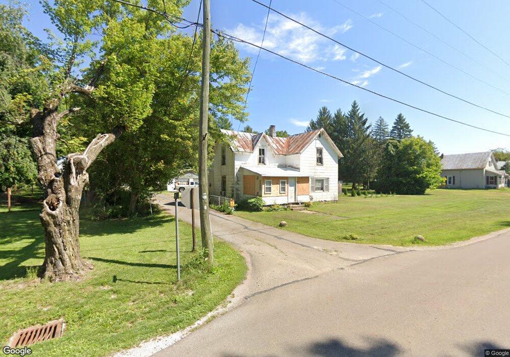
123 E Main St Fulton, OH 43321
Estimated Value: $165,795 - $255,000
3
Beds
2
Baths
1,778
Sq Ft
$113/Sq Ft
Est. Value
About This Home
This home is located at 123 E Main St, Fulton, OH 43321 and is currently estimated at $201,699, approximately $113 per square foot. 123 E Main St is a home located in Morrow County with nearby schools including Cardington-Lincoln Elementary School, Cardington Intermediate School, and Cardington-Lincoln High School.
Ownership History
Date
Name
Owned For
Owner Type
Purchase Details
Closed on
Dec 17, 2021
Bought by
Raymond D Carsner and Jean Peggy
Current Estimated Value
Purchase Details
Closed on
Oct 3, 2007
Sold by
Hoffman Kenneth E
Bought by
Carsner Raymond D and Peggy Jean
Purchase Details
Closed on
Sep 8, 2004
Sold by
Hoffman Kenneth E and Hoffman Ethel I
Bought by
Hoffman Kenneth E
Purchase Details
Closed on
Feb 21, 2001
Sold by
Hoffman Kenneth E
Bought by
Hoffman Kenneth E and Hoffman Ethel I
Purchase Details
Closed on
Jan 1, 1990
Bought by
Hoffman Kenneth E
Create a Home Valuation Report for This Property
The Home Valuation Report is an in-depth analysis detailing your home's value as well as a comparison with similar homes in the area
Purchase History
| Date | Buyer | Sale Price | Title Company |
|---|---|---|---|
| Raymond D Carsner | -- | -- | |
| Carsner Raymond D | $80,000 | -- | |
| Hoffman Kenneth E | -- | -- | |
| Hoffman Kenneth E | -- | -- | |
| Hoffman Kenneth E | -- | -- |
Source: Public Records
Tax History
| Year | Tax Paid | Tax Assessment Tax Assessment Total Assessment is a certain percentage of the fair market value that is determined by local assessors to be the total taxable value of land and additions on the property. | Land | Improvement |
|---|---|---|---|---|
| 2025 | $2,607 | $33,220 | $2,140 | $31,080 |
| 2024 | $1,593 | $33,220 | $2,140 | $31,080 |
| 2023 | $1,448 | $33,220 | $2,140 | $31,080 |
| 2022 | $1,445 | $28,630 | $2,520 | $26,110 |
| 2021 | $1,363 | $28,630 | $2,520 | $26,110 |
| 2020 | $1,349 | $28,630 | $2,520 | $26,110 |
| 2019 | $1,190 | $24,260 | $2,140 | $22,120 |
| 2018 | $1,187 | $24,260 | $2,140 | $22,120 |
| 2017 | $1,159 | $24,260 | $2,140 | $22,120 |
| 2016 | $1,120 | $23,280 | $2,590 | $20,690 |
| 2015 | $978 | $23,280 | $2,590 | $20,690 |
| 2014 | $996 | $23,280 | $2,590 | $20,690 |
| 2013 | $1,059 | $24,500 | $2,730 | $21,770 |
Source: Public Records
Map
Nearby Homes
- 3310 State Route 61
- 2504 County Road 26
- 2321 County Road 24
- 4515 Township Road 179
- 0 County Rd 23 Unit 226004062
- 0 County Road 25 Unit 20850665
- 3140 State Highway 529
- 4920 Township Road 179
- 1905 County Road 26
- 0001 County Road 123
- 2735 Township Road 20
- 3919 Township Road 144
- 1936 County Road 170
- 4910 Township Road 191
- 0 County Road 170 Unit 20850667
- 0 County Road 170 Unit 20850668
- 4449 County Road 114
- 229 Gilead St
- 5360 Township Road 187
- 139 Gilead St
Your Personal Tour Guide
Ask me questions while you tour the home.