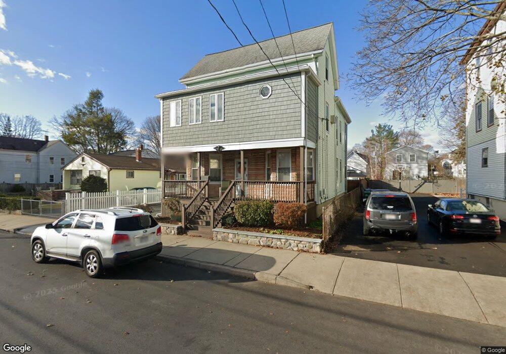
124 Flint St Lynn, MA 01905
Lower Boston Street NeighborhoodEstimated Value: $684,071 - $814,000
4
Beds
2
Baths
2,047
Sq Ft
$369/Sq Ft
Est. Value
About This Home
This home is located at 124 Flint St, Lynn, MA 01905 and is currently estimated at $754,518, approximately $368 per square foot. 124 Flint St is a home located in Essex County with nearby schools including William R. Fallon School, Lincoln-Thomson Elementary School, and Breed Middle School.
Ownership History
Date
Name
Owned For
Owner Type
Purchase Details
Closed on
Jan 1, 1977
Bought by
Byrne Patrick R and Byrne Kathleen A
Current Estimated Value
Create a Home Valuation Report for This Property
The Home Valuation Report is an in-depth analysis detailing your home's value as well as a comparison with similar homes in the area
Home Values in the Area
Average Home Value in this Area
Purchase History
We collect this data history from publicly available records. To have your information removed, we recommend requesting removal directly through your county’s website.
| Date | Buyer | Sale Price | Title Company |
|---|---|---|---|
| Byrne Patrick R | -- | -- |
Source: Public Records
Mortgage History
We collect this data history from publicly available records. To have your information removed, we recommend requesting removal directly through your county’s website.
| Date | Status | Borrower | Loan Amount |
|---|---|---|---|
| Open | Byrne Patrick R | $165,000 | |
| Closed | Byrne Patrick R | $50,000 | |
| Closed | Byrne Patrick R | $140,000 |
Source: Public Records
Tax History
| Year | Tax Paid | Tax Assessment Tax Assessment Total Assessment is a certain percentage of the fair market value that is determined by local assessors to be the total taxable value of land and additions on the property. | Land | Improvement |
|---|---|---|---|---|
| 2025 | $7,251 | $699,862 | $226,600 | $473,262 |
| 2024 | $6,717 | $637,900 | $199,100 | $438,800 |
| 2023 | $6,853 | $614,600 | $205,600 | $409,000 |
| 2022 | $6,620 | $532,600 | $152,300 | $380,300 |
| 2021 | $6,257 | $480,200 | $140,000 | $340,200 |
| 2020 | $5,857 | $437,100 | $134,800 | $302,300 |
| 2019 | $5,711 | $399,400 | $126,900 | $272,500 |
| 2018 | $5,628 | $371,500 | $140,000 | $231,500 |
| 2017 | $5,156 | $330,500 | $116,400 | $214,100 |
| 2016 | $4,836 | $298,900 | $108,900 | $190,000 |
| 2015 | $4,650 | $277,600 | $108,100 | $169,500 |
Source: Public Records
Map
Nearby Homes
- 26 Kirtland St
- 74 Linwood St
- 74 Myrtle St
- 82 Linwood St
- 47 Myrtle St
- 23 N Federal St
- 36 Stiles St
- 15 Perley St
- 53 Dungeon Ave
- 56 Gardiner St
- 86 Farrell Rd
- 13 Moulton St
- 32 Birch Brook Rd Unit 27
- 32 Birch Brook Rd Unit 28
- 32 Birch Brook Landing Unit 9
- 32 Birch Brook Landing Unit 25
- 32 Birch Brook Landing Unit 11
- 32 Birch Brook Landing Unit 4
- 11 Willis Ct
- 51 Laurel St
- 132 Flint St
- 136 Flint St
- 128 Flint St
- 128 Flint St Unit 3
- 140 Flint St
- 133 Wyman St
- 137 Wyman St
- 129 Wyman St
- 125 Wyman St
- 139 Wyman St Unit 141
- 139-141 Wyman St
- 139 Wyman St Unit 1
- 139 Wyman St Unit B
- 127 Flint St
- 141 Wyman St Unit 1
- 131 Flint St
- 118 Flint St
- 135 Flint St
- 184 Walnut St
- 123 Flint St
Your Personal Tour Guide
Ask me questions while you tour the home.