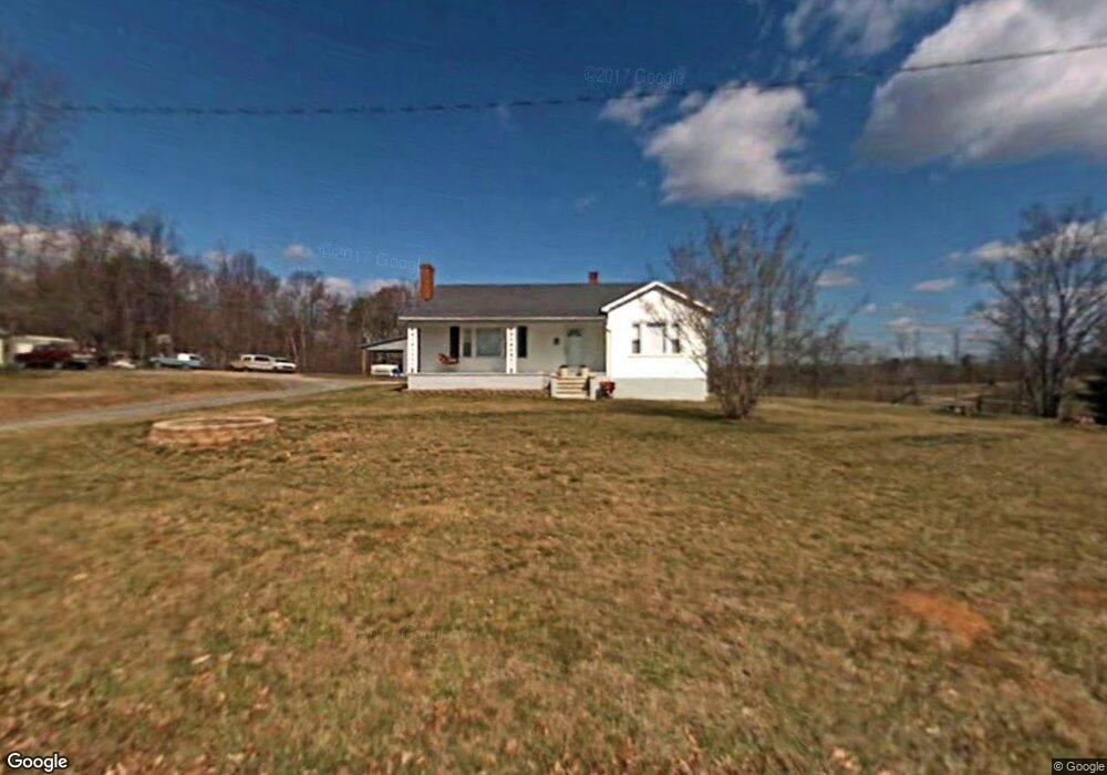
1251 Mcbride Rd Mount Airy, NC 27030
Estimated Value: $170,000 - $207,000
3
Beds
1
Bath
1,214
Sq Ft
$156/Sq Ft
Est. Value
About This Home
This home is located at 1251 Mcbride Rd, Mount Airy, NC 27030 and is currently estimated at $188,917, approximately $155 per square foot. 1251 Mcbride Rd is a home with nearby schools including Flat Rock Elementary School, Meadowview Magnet Middle School, and North Surry High School.
Ownership History
Date
Name
Owned For
Owner Type
Purchase Details
Closed on
Dec 19, 2014
Sold by
Slate Darrell E
Bought by
Slate Denise K
Current Estimated Value
Purchase Details
Closed on
Aug 1, 2006
Sold by
Haynes John B and Haynes Barbara John
Bought by
Slate Darrell and Slate Denise
Home Financials for this Owner
Home Financials are based on the most recent Mortgage that was taken out on this home.
Original Mortgage
$60,000
Outstanding Balance
$35,738
Interest Rate
6.71%
Mortgage Type
New Conventional
Estimated Equity
$153,179
Create a Home Valuation Report for This Property
The Home Valuation Report is an in-depth analysis detailing your home's value as well as a comparison with similar homes in the area
Purchase History
We collect this data history from publicly available records. To have your information removed, we recommend requesting removal directly through your county’s website.
| Date | Buyer | Sale Price | Title Company |
|---|---|---|---|
| Slate Denise K | -- | None Available | |
| Slate Darrell | $75,000 | None Available |
Source: Public Records
Mortgage History
We collect this data history from publicly available records. To have your information removed, we recommend requesting removal directly through your county’s website.
| Date | Status | Borrower | Loan Amount |
|---|---|---|---|
| Open | Slate Darrell | $60,000 |
Source: Public Records
Tax History
| Year | Tax Paid | Tax Assessment Tax Assessment Total Assessment is a certain percentage of the fair market value that is determined by local assessors to be the total taxable value of land and additions on the property. | Land | Improvement |
|---|---|---|---|---|
| 2025 | $553 | $79,480 | $10,000 | $69,480 |
| 2024 | $486 | $65,810 | $10,000 | $55,810 |
| 2023 | $479 | $65,810 | $10,000 | $55,810 |
| 2022 | $486 | $65,810 | $10,000 | $55,810 |
| 2021 | $486 | $65,810 | $10,000 | $55,810 |
| 2020 | $462 | $59,810 | $10,000 | $49,810 |
| 2019 | $459 | $59,810 | $0 | $0 |
| 2018 | $452 | $59,810 | $0 | $0 |
| 2017 | $448 | $59,810 | $0 | $0 |
| 2016 | $444 | $59,810 | $0 | $0 |
| 2013 | -- | $59,720 | $0 | $0 |
Source: Public Records
Map
Nearby Homes
- 184 Beasley Rd
- xx 44.93 Acres Stardust Trail
- 126 Sycamore Dr
- 236 Badgett Ave
- 263 Badgett Ave
- 335 Badgett Ave
- TBD Glen Terrace
- 329 Graystone Rd
- 2638 Riverside Dr
- 0 NE Pine St
- 0 Ararat Hwy
- 1970 Mcbride Rd
- 00 Paynetown Rd
- 549 Ararat Hwy
- 2828 E Pine St
- 1611 E Pine St
- 279 Stanley Rd
- 125 Cabin Ln
- 124 Rocky Ln
- 2160 Margaret Dr
- 1237 Mcbride Rd
- 1269 Mcbride Rd
- 1252 Mcbride Rd
- 1270 Mcbride Rd
- 1301 Mcbride Rd
- 1200 Mcbride Rd
- 1603 Mcbride Rd
- 112 Beasley Rd
- 1302 Mcbride Rd
- 1186 Mcbride Rd
- 111 Beasley Rd
- 1176 Mcbride Rd
- 1166 Mcbride Rd
- 1353 Mcbride Rd
- 152 Beasley Rd
- 1161 Mcbride Rd
- 145 Beasley Rd
- 1144 Mcbride Rd
- 1144 Mcbride Rd
- 0 Stardust Trail
Your Personal Tour Guide
Ask me questions while you tour the home.