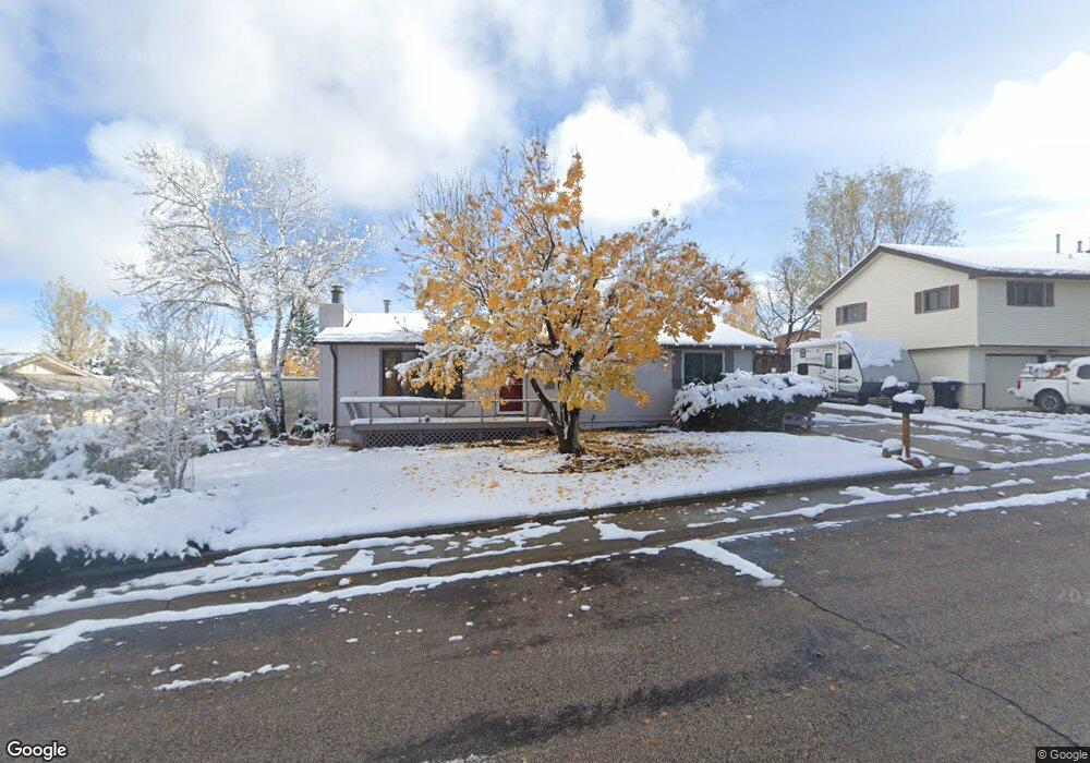
1265 Mcdougall Dr Lander, WY 82520
Estimated Value: $344,000 - $422,000
About This Home
This home is located at 1265 Mcdougall Dr, Lander, WY 82520 and is currently estimated at $374,670, approximately $266 per square foot. 1265 Mcdougall Dr is a home located in Fremont County with nearby schools including Lander Valley High School and Lander Christian Academy.
Ownership History
We collect this data history from publicly available records. To have your information removed, we recommend requesting removal directly through your county’s website.
Purchase Details
Purchase Details
Home Values in the Area
Average Home Value in this Area
Purchase History
We collect this data history from publicly available records. To have your information removed, we recommend requesting removal directly through your county’s website.
| Date | Buyer | Sale Price | Title Company |
|---|---|---|---|
| -- | None Available | ||
| -- | Fremont County Title |
Mortgage History
We collect this data history from publicly available records. To have your information removed, we recommend requesting removal directly through your county’s website.
| Date | Status | Borrower | Loan Amount |
|---|---|---|---|
| Closed | $167,835 | ||
| Closed | $94,500 |
Tax History
We collect this data history from publicly available records. To have your information removed, we recommend requesting removal directly through your county’s website.
| Year | Tax Paid | Tax Assessment Tax Assessment Total Assessment is a certain percentage of the fair market value that is determined by local assessors to be the total taxable value of land and additions on the property. | Land | Improvement |
|---|---|---|---|---|
| 2025 | $2,152 | $22,004 | $3,811 | $18,193 |
| 2024 | $2,152 | $27,886 | $5,081 | $22,805 |
| 2023 | $1,833 | $26,934 | $4,923 | $22,011 |
| 2022 | $1,490 | $22,884 | $4,923 | $17,961 |
| 2021 | $1,325 | $20,120 | $4,795 | $15,325 |
| 2020 | $1,326 | $20,170 | $4,795 | $15,375 |
| 2019 | $1,307 | $19,654 | $4,764 | $14,890 |
| 2018 | $1,294 | $19,302 | $4,764 | $14,538 |
| 2017 | $1,231 | $18,475 | $4,764 | $13,711 |
| 2016 | $1,231 | $18,496 | $4,764 | $13,732 |
| 2015 | $1,199 | $18,268 | $4,764 | $13,504 |
| 2014 | $927 | $14,814 | $4,764 | $10,050 |
Map
- 1105 Mcdougall Dr
- 935 Cliff St
- 1020 Mcdougall Dr
- 770 Shoshone St
- 846 S 7th St
- 1185 Goodrich Dr
- 839 S 6th St
- 975 Dabich Ave
- 120 Roaring Fork Ct
- 960 Dabich Ave
- 1285 Goodrich Dr
- 915 Black Blvd
- 1345 Goodrich Dr
- 574 W Brodie St
- 835 Garfield St
- 485 S 5th St
- 345 Shoshone St
- 345 Shoshone Ave
- 900 Lincoln St
- 930 Lincoln St
- 1275 Mcdougall Dr
- 1255 Mcdougall Dr
- 1255 Mcdougall Dr Unit Smith
- 799 Welch Blvd
- 801 Welch Blvd
- 797 Welch Blvd
- 1285 Mcdougall Dr
- 1245 Mcdougall Dr
- 1245 Mcdougall Dr Unit S. 9th
- 1245 Mcdougall Dr Unit Cascade
- 1250 Mcdougall Dr
- 1240 Mcdougall Dr
- 1260 Mcdougall Dr
- 795 Welch Blvd
- 795 Welch Blvd Unit Cascade
- 803 Welch Blvd
- 1295 Mcdougall Dr
- 1235 Mcdougall Dr
- 1230 Mcdougall Dr
- 800 Welch Blvd
Ask me questions while you tour the home.