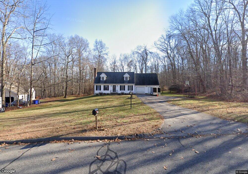
129 Stonebridge Rd Coventry, CT 06238
Estimated Value: $458,782 - $509,000
4
Beds
3
Baths
1,896
Sq Ft
$255/Sq Ft
Est. Value
About This Home
This home is located at 129 Stonebridge Rd, Coventry, CT 06238 and is currently estimated at $483,196, approximately $254 per square foot. 129 Stonebridge Rd is a home located in Tolland County with nearby schools including George Hersey Robertson School, Coventry Grammar School, and Capt. Nathan Hale School.
Ownership History
Date
Name
Owned For
Owner Type
Purchase Details
Closed on
Mar 28, 2003
Sold by
Sicard Edward
Bought by
Kearney J Scott and Kearney Jennifer
Current Estimated Value
Purchase Details
Closed on
Nov 19, 1993
Sold by
Westwood Park Inc
Bought by
Sicard Edward
Purchase Details
Closed on
Jul 1, 1993
Sold by
England Wayne and Mayland Elaine
Bought by
Ripley Ridge Ests Inc
Create a Home Valuation Report for This Property
The Home Valuation Report is an in-depth analysis detailing your home's value as well as a comparison with similar homes in the area
Home Values in the Area
Average Home Value in this Area
Purchase History
| Date | Buyer | Sale Price | Title Company |
|---|---|---|---|
| Kearney J Scott | $237,800 | -- | |
| Sicard Edward | $155,555 | -- | |
| Ripley Ridge Ests Inc | $68,500 | -- | |
| Kearney J Scott J | $237,800 | -- | |
| Ripley Ridge Ests Inc | $68,500 | -- |
Source: Public Records
Mortgage History
| Date | Status | Borrower | Loan Amount |
|---|---|---|---|
| Open | Ripley Ridge Ests Inc | $232,000 | |
| Closed | Ripley Ridge Ests Inc | $229,600 | |
| Closed | Ripley Ridge Ests Inc | $206,400 |
Source: Public Records
Tax History
| Year | Tax Paid | Tax Assessment Tax Assessment Total Assessment is a certain percentage of the fair market value that is determined by local assessors to be the total taxable value of land and additions on the property. | Land | Improvement |
|---|---|---|---|---|
| 2025 | $7,059 | $297,100 | $60,100 | $237,000 |
| 2024 | $6,089 | $182,800 | $49,800 | $133,000 |
| 2023 | $5,802 | $182,800 | $49,800 | $133,000 |
| 2022 | $5,694 | $182,800 | $49,800 | $133,000 |
| 2021 | $5,694 | $182,800 | $49,800 | $133,000 |
| 2020 | $5,698 | $182,800 | $49,800 | $133,000 |
| 2019 | $5,886 | $182,800 | $49,800 | $133,000 |
| 2018 | $5,786 | $179,700 | $49,800 | $129,900 |
| 2017 | $5,750 | $179,700 | $49,800 | $129,900 |
| 2016 | $5,607 | $179,700 | $49,800 | $129,900 |
| 2015 | $5,607 | $179,700 | $49,800 | $129,900 |
| 2014 | $5,754 | $202,100 | $60,300 | $141,800 |
Source: Public Records
Map
Nearby Homes
- 550 High St
- 1091 Flanders Rd
- 198 Forest Rd
- 97 Armstrong Rd
- 316 Shore Dr
- 0 Woodland Rd
- 103 S Street Extension
- 106 S Street Extension
- 498 Root Rd
- 55 Whites Hill Rd
- 17 Ireland Dr
- 152 Cheney Ln
- 0 Hinkel Mae Dr
- 0 Seneca Trail
- 27 Fox Trail
- 17 Route 6
- 31 Wyllys Farm Rd
- 1 Whitney Rd
- 35 Wyllys Farm Rd
- 9 Sheffield Dr
- 121 Stonebridge Rd
- 153 Stonebridge Rd
- 356 High St
- 140 Stonebridge Rd
- 124 Stonebridge Rd
- 169 Stonebridge Rd
- 103 Stonebridge Rd
- 104 Stonebridge Rd
- 168 Stonebridge Rd
- 183 Stonebridge Rd
- 89 Stonebridge Rd
- 000 Stone Bridge Rd
- 86 Stonebridge Rd
- 184 Stonebridge Rd
- 185 Stonebridge Rd
- 354 High St
- 186 Stonebridge Rd
- 84 Stonebridge Rd
- 272 High St
- 266 High St
Your Personal Tour Guide
Ask me questions while you tour the home.