Estimated Value: $280,140 - $350,000
3
Beds
2
Baths
1,662
Sq Ft
$185/Sq Ft
Est. Value
About This Home
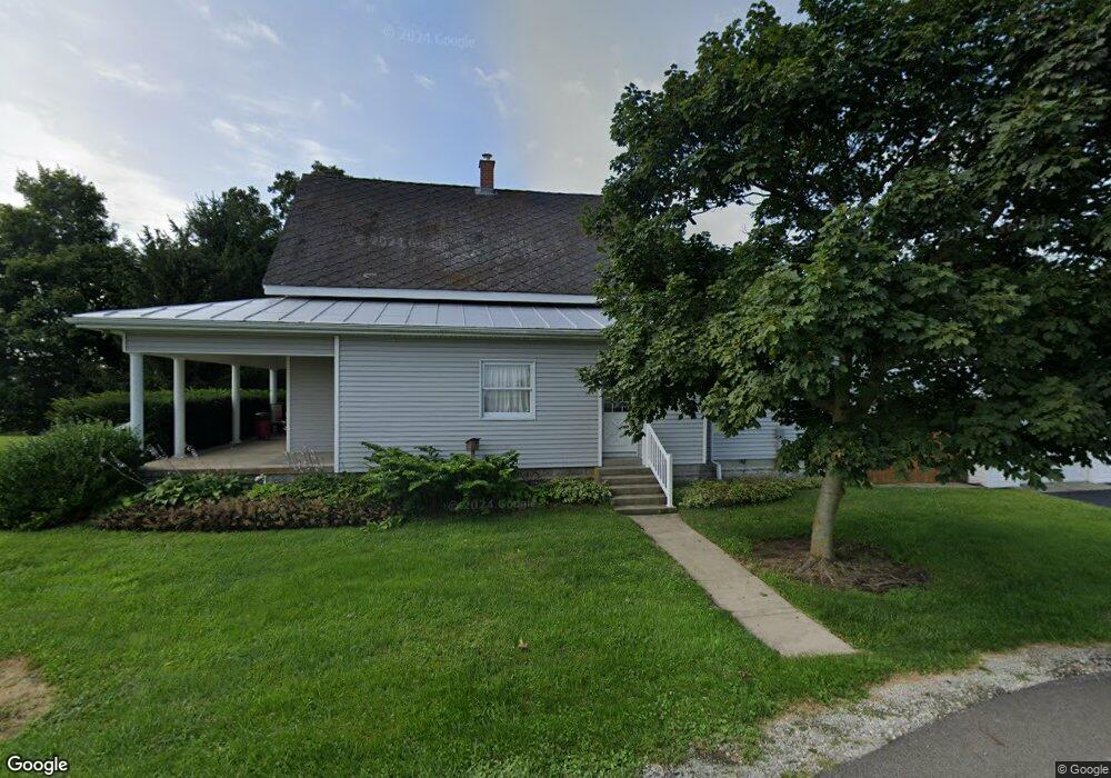
This home is located at 1292 E Consolidated Rd, Eaton, OH 45320 and is currently estimated at $307,285, approximately $184 per square foot. 1292 E Consolidated Rd is a home located in Preble County with nearby schools including William Bruce Elementary School, Hollingsworth East Elementary School, and Eaton Middle School.
Ownership History
Date
Name
Owned For
Owner Type
Purchase Details
Closed on
Aug 31, 2006
Sold by
Rice Christine K
Bought by
Rice Robert J
Current Estimated Value
Purchase Details
Closed on
Jun 25, 2004
Sold by
Dutter Andy L and Dutter Suzanne A
Bought by
Rice Robert J and Rice Christine K
Home Financials for this Owner
Home Financials are based on the most recent Mortgage that was taken out on this home.
Original Mortgage
$90,000
Outstanding Balance
$43,717
Interest Rate
6.46%
Mortgage Type
Purchase Money Mortgage
Estimated Equity
$263,568
Purchase Details
Closed on
Aug 10, 1998
Sold by
Dutter Galen
Bought by
Dutter Andy L and Dutter Suzanne A
Purchase Details
Closed on
Oct 3, 1990
Bought by
Rice Robert J
Create a Home Valuation Report for This Property
The Home Valuation Report is an in-depth analysis detailing your home's value as well as a comparison with similar homes in the area
Purchase History
| Date | Buyer | Sale Price | Title Company |
|---|---|---|---|
| Rice Robert J | -- | Attorney | |
| Rice Robert J | $165,800 | None Available | |
| Dutter Andy L | $100,000 | -- | |
| Rice Robert J | $55,000 | -- |
Source: Public Records
Mortgage History
| Date | Status | Borrower | Loan Amount |
|---|---|---|---|
| Open | Rice Robert J | $90,000 |
Source: Public Records
Tax History
| Year | Tax Paid | Tax Assessment Tax Assessment Total Assessment is a certain percentage of the fair market value that is determined by local assessors to be the total taxable value of land and additions on the property. | Land | Improvement |
|---|---|---|---|---|
| 2025 | $2,548 | $70,360 | $15,160 | $55,200 |
| 2024 | $2,548 | $70,360 | $15,160 | $55,200 |
| 2023 | $2,520 | $70,360 | $15,160 | $55,200 |
| 2022 | $2,132 | $48,200 | $14,320 | $33,880 |
| 2021 | $2,228 | $48,200 | $14,320 | $33,880 |
| 2020 | $2,129 | $48,200 | $14,320 | $33,880 |
| 2019 | $1,893 | $42,010 | $12,990 | $29,020 |
| 2018 | $1,909 | $42,010 | $12,990 | $29,020 |
| 2017 | $1,915 | $42,010 | $12,990 | $29,020 |
| 2016 | $1,557 | $36,470 | $12,600 | $23,870 |
| 2014 | $1,508 | $36,470 | $12,600 | $23,870 |
| 2013 | $1,571 | $36,470 | $12,600 | $23,870 |
Source: Public Records
Map
Nearby Homes
- 409 Chestnut Dr
- 401 Chestnut Dr
- 350 Frizzell Ave
- 315 Evergreen Dr
- 218 Nation Ave
- 321 Liberty St
- 216 Vine St
- 216 S Franklin St
- 232 Goldenrod Dr
- 71 Quaker Trace Rd
- 1568 Wolf Rd
- 235 East Ave
- 922 E High St
- 600 E Somers St
- 113 S Barron St
- 200 E Somers St
- 456 Meadowlark Ln
- 455 Meadowlark Ln
- 224 N Barron St
- 115 E Decatur St
- 2719 State Route 122 S
- 2512 State Route 122 S
- 2512 State Route 122 S
- 1184 E Consolidated Rd
- 1076 E Consolidated Rd
- 2884 State Route 122 S
- 2304 State Route 122 S
- 2304 Ohio 122
- 100 Fishr Twn Rd
- 3058 State Route 122 S
- 1702 Fisher Twin Rd
- 2073 State Route 122 S
- 1845 Wayne Trace Rd
- 3245 State Route 122 S
- 687 E Consolidated Rd
- 687 E Consolidated Rd
- 1899 Wayne Trace Rd
- 0 Consolidated Rd Unit 1802665
- 0 Consolidated Rd
- 2441 Wayne Trace Rd
Your Personal Tour Guide
Ask me questions while you tour the home.