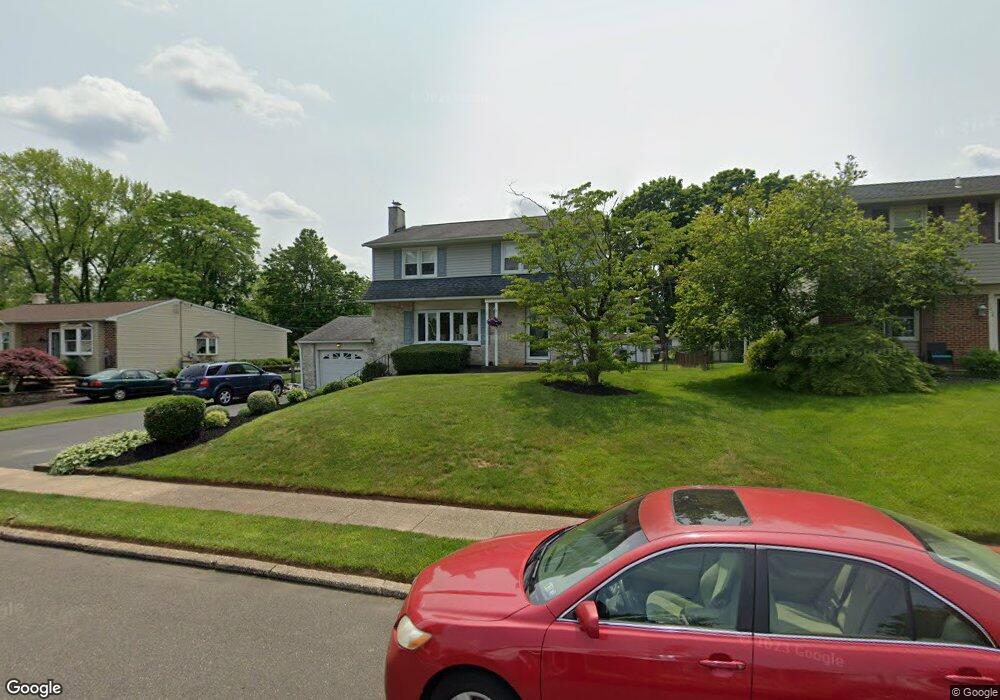
1304 Beverly Rd Warminster, PA 18974
Estimated Value: $448,000 - $543,000
3
Beds
2
Baths
2,320
Sq Ft
$216/Sq Ft
Est. Value
About This Home
This home is located at 1304 Beverly Rd, Warminster, PA 18974 and is currently estimated at $502,217, approximately $216 per square foot. 1304 Beverly Rd is a home located in Bucks County with nearby schools including Willow Dale Elementary School, Log College Middle School, and William Tennent High School.
Ownership History
Date
Name
Owned For
Owner Type
Purchase Details
Closed on
Oct 14, 1994
Sold by
Pelosi Louis P and Pelosi Kathy
Bought by
Ardis Kevin L and Ardis Brenda L
Current Estimated Value
Home Financials for this Owner
Home Financials are based on the most recent Mortgage that was taken out on this home.
Original Mortgage
$139,650
Interest Rate
8.49%
Purchase Details
Closed on
Aug 4, 1978
Bought by
Pelosi Louis P and Pelosi Kathy
Create a Home Valuation Report for This Property
The Home Valuation Report is an in-depth analysis detailing your home's value as well as a comparison with similar homes in the area
Home Values in the Area
Average Home Value in this Area
Purchase History
| Date | Buyer | Sale Price | Title Company |
|---|---|---|---|
| Ardis Kevin L | $147,000 | -- | |
| Pelosi Louis P | $52,000 | -- |
Source: Public Records
Mortgage History
| Date | Status | Borrower | Loan Amount |
|---|---|---|---|
| Closed | Ardis Kevin L | $139,650 |
Source: Public Records
Tax History
| Year | Tax Paid | Tax Assessment Tax Assessment Total Assessment is a certain percentage of the fair market value that is determined by local assessors to be the total taxable value of land and additions on the property. | Land | Improvement |
|---|---|---|---|---|
| 2025 | $5,910 | $28,000 | $4,360 | $23,640 |
| 2024 | $5,910 | $28,000 | $4,360 | $23,640 |
| 2023 | $5,728 | $28,000 | $4,360 | $23,640 |
| 2022 | $5,606 | $28,000 | $4,360 | $23,640 |
| 2021 | $5,475 | $28,000 | $4,360 | $23,640 |
| 2020 | $5,398 | $28,000 | $4,360 | $23,640 |
| 2019 | $5,111 | $28,000 | $4,360 | $23,640 |
| 2018 | $4,989 | $28,000 | $4,360 | $23,640 |
| 2017 | $4,843 | $28,000 | $4,360 | $23,640 |
| 2016 | $4,843 | $28,000 | $4,360 | $23,640 |
| 2015 | $4,901 | $28,000 | $4,360 | $23,640 |
| 2014 | $4,901 | $28,000 | $4,360 | $23,640 |
Source: Public Records
Map
Nearby Homes
- 1228 Clyde Rd
- 60 Caledonia Dr
- 532 Sherwood Ln
- 240 Clearfield Cir
- 1171 W County Line Rd
- 253 Kent Rd
- 607 America Dr
- 602 America Dr Unit FARADAY MODEL HOME
- 64 Villa Dr Unit 206
- 604 America #Northbrook Model Dr
- 619 America Dr
- 604 Liberty Ridge Rd
- 18 Patriot Ln
- 616 Liberty Ridge Rd
- 25 Patriot Ln
- 619 Liberty Ridge Rd
- 36 Patriot Ln
- 623 Liberty Ridge Rd
- 173 Villa Dr Unit 100
- 327 S Norristown Rd
- 1296 Beverly Rd
- 1312 Beverly Rd
- 1320 Beverly Rd
- 1290 Beverly Rd
- 125 Wellington Dr
- 1309 Caledonia Dr
- 1299 Caledonia Dr
- 1328 Beverly Rd
- 124 Kipling Dr
- 1319 Caledonia Dr
- 1282 Beverly Rd
- 126 Wellington Dr
- 132 Kipling Dr
- 1289 Caledonia Dr
- 135 Wellington Dr
- 1334 Beverly Rd
- 132 Wellington Dr
- 1329 Caledonia Dr
- 1279 Caledonia Dr
- 140 Kipling Dr
Your Personal Tour Guide
Ask me questions while you tour the home.