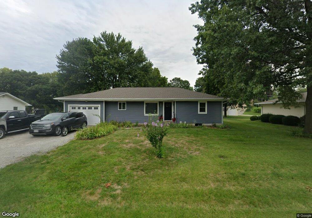
1305 State Route T Savannah, MO 64485
Estimated Value: $269,000 - $352,000
3
Beds
2
Baths
1,924
Sq Ft
$154/Sq Ft
Est. Value
About This Home
This home is located at 1305 State Route T, Savannah, MO 64485 and is currently estimated at $295,926, approximately $153 per square foot. 1305 State Route T is a home with nearby schools including Minnie Cline Elementary School and Savannah Middle School.
Ownership History
Date
Name
Owned For
Owner Type
Purchase Details
Closed on
Mar 29, 2018
Sold by
Young Irt
Bought by
Chambers Robert J and Chambers Omeara-Chambers T
Current Estimated Value
Home Financials for this Owner
Home Financials are based on the most recent Mortgage that was taken out on this home.
Original Mortgage
$67,800
Outstanding Balance
$57,297
Interest Rate
4.43%
Mortgage Type
Undefined Multiple Amounts
Estimated Equity
$238,629
Create a Home Valuation Report for This Property
The Home Valuation Report is an in-depth analysis detailing your home's value as well as a comparison with similar homes in the area
Home Values in the Area
Average Home Value in this Area
Purchase History
| Date | Buyer | Sale Price | Title Company |
|---|---|---|---|
| Chambers Robert J | -- | -- |
Source: Public Records
Mortgage History
| Date | Status | Borrower | Loan Amount |
|---|---|---|---|
| Open | Chambers Robert J | $67,800 |
Source: Public Records
Tax History
| Year | Tax Paid | Tax Assessment Tax Assessment Total Assessment is a certain percentage of the fair market value that is determined by local assessors to be the total taxable value of land and additions on the property. | Land | Improvement |
|---|---|---|---|---|
| 2025 | $2,494 | $40,580 | $4,950 | $35,630 |
| 2024 | $2,494 | $37,880 | $4,950 | $32,930 |
| 2023 | $2,458 | $37,880 | $4,950 | $32,930 |
| 2022 | $2,454 | $37,880 | $4,950 | $32,930 |
| 2021 | $1,167 | $18,670 | $4,950 | $13,720 |
| 2020 | $1,139 | $18,670 | $4,950 | $13,720 |
| 2019 | $1,134 | $18,260 | $4,540 | $13,720 |
| 2018 | $1,097 | $18,060 | $4,540 | $13,520 |
| 2017 | $0 | $18,060 | $4,540 | $13,520 |
| 2016 | $1,103 | $18,060 | $4,540 | $13,520 |
| 2015 | -- | $18,060 | $4,540 | $13,520 |
| 2011 | -- | $90,190 | $23,900 | $66,290 |
Source: Public Records
Map
Nearby Homes
- 704 S 12th Terrace
- 1205 W Park Ave
- 1407 W Main Terrace
- 1213 W Chestnut St
- 307 N 14th St
- 1506 W William St
- 1508 W William St
- 206 N 8th St
- 203 S 6th St
- 1012 S 7th St
- 904 S 5th St
- 604 N 13th Terrace
- 503 W Elk St
- 301 N 5th St
- 105 W Price Ave
- 803 N 15th Terrace
- 0 W Duncan Dr
- 508 E Price Ave
- 702 E Maple Place
- 1112 S Beech St
- 1303 State Route T
- 1307 State Route T
- 500 S 12th Terrace
- 1303 W Maple St
- 1304 W Benton St
- 1304 W Maple St
- 1306 W Benton St
- 1302 W Benton St
- 503 S 12th Terrace
- 1308 W Benton St
- 1300 W Benton St
- 508 S 12th Terrace
- 505 S 12th Terrace
- 504 S 14th St
- 1208 W Benton St
- 404 S 14th St
- 601 S 13 St
- 601 S 13th Terrace
- 1204 W Nelson St
- 1206 W Benton St
Your Personal Tour Guide
Ask me questions while you tour the home.