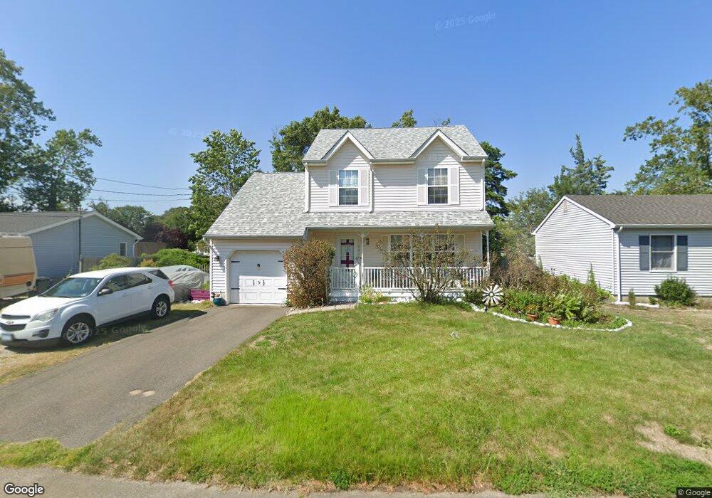
131 E Cape May Ave Ocean Gate, NJ 08740
Estimated Value: $405,407 - $524,000
3
Beds
2
Baths
1,392
Sq Ft
$348/Sq Ft
Est. Value
About This Home
This home is located at 131 E Cape May Ave, Ocean Gate, NJ 08740 and is currently estimated at $485,102, approximately $348 per square foot. 131 E Cape May Ave is a home located in Ocean County with nearby schools including Ocean Gate Elementary School, Central Regional Middle School, and Central Regional High School.
Ownership History
Date
Name
Owned For
Owner Type
Purchase Details
Closed on
Feb 22, 1999
Sold by
Vacchiano Frank and Vacchiano Frank A
Bought by
Hermann Dianne A
Current Estimated Value
Home Financials for this Owner
Home Financials are based on the most recent Mortgage that was taken out on this home.
Original Mortgage
$96,000
Outstanding Balance
$22,762
Interest Rate
6.76%
Mortgage Type
Stand Alone First
Estimated Equity
$462,340
Purchase Details
Closed on
May 4, 1998
Sold by
Niclaus Doris C and Niclaus Walter O
Bought by
Vacchiano Frank
Home Financials for this Owner
Home Financials are based on the most recent Mortgage that was taken out on this home.
Original Mortgage
$102,750
Interest Rate
7.03%
Mortgage Type
Balloon
Create a Home Valuation Report for This Property
The Home Valuation Report is an in-depth analysis detailing your home's value as well as a comparison with similar homes in the area
Home Values in the Area
Average Home Value in this Area
Purchase History
| Date | Buyer | Sale Price | Title Company |
|---|---|---|---|
| Hermann Dianne A | $120,000 | -- | |
| Vacchiano Frank | $20,000 | Independence Abstract & Titl |
Source: Public Records
Mortgage History
| Date | Status | Borrower | Loan Amount |
|---|---|---|---|
| Open | Hermann Dianne A | $96,000 | |
| Previous Owner | Vacchiano Frank | $102,750 |
Source: Public Records
Tax History
| Year | Tax Paid | Tax Assessment Tax Assessment Total Assessment is a certain percentage of the fair market value that is determined by local assessors to be the total taxable value of land and additions on the property. | Land | Improvement |
|---|---|---|---|---|
| 2025 | $7,018 | $385,400 | $184,300 | $201,100 |
| 2024 | $6,086 | $385,400 | $184,300 | $201,100 |
| 2023 | $5,607 | $201,600 | $68,700 | $132,900 |
| 2022 | $5,607 | $201,600 | $68,700 | $132,900 |
| 2021 | $4,917 | $201,600 | $68,700 | $132,900 |
| 2020 | $5,409 | $201,600 | $68,700 | $132,900 |
| 2019 | $5,278 | $201,600 | $68,700 | $132,900 |
| 2018 | $5,094 | $201,600 | $68,700 | $132,900 |
| 2017 | $5,056 | $201,600 | $68,700 | $132,900 |
| 2016 | $5,016 | $201,600 | $68,700 | $132,900 |
| 2015 | $5,244 | $257,300 | $118,800 | $138,500 |
| 2014 | $5,267 | $257,300 | $118,800 | $138,500 |
Source: Public Records
Map
Nearby Homes
- 375 E Barnegat Ave
- 129 E Long Branch Ave
- 32 E Long Branch Ave
- 318 E Cape May Ave
- 24 W Point Pleasant Ave
- 36 W Point Pleasant Ave
- 707 Navesink Ave
- 207 Ocean Gate Ave
- 117 W Arverne Ave
- 553 Ocean Gate Dr
- 319 Monmouth Ave
- 3 Sheila Ct
- 0 Jane Ave
- 521 E Point Pleasant Ave
- 521 E Long Branch Ave
- 2 Jane Ave
- 803 Ocean Gate Dr
- 277 Bayville Ave
- 39 Ivy Ct
- 601 E Arverne Ave
- 125 E Cape May Ave
- 139 E Cape May Ave
- 130 E Point Pleasant Ave
- 128 E Point Pleasant Ave
- 145 E Cape May Ave
- 140 E Point Pleasant Ave
- 120 E Point Pleasant Ave
- 115 E Cape May Ave
- 716 Wildwood Ave
- 712 Wildwood Ave
- 708 Wildwood Ave
- 110 E Point Pleasant Ave
- 123 E Point Pleasant Ave
- 119 E Point Pleasant Ave
- 127 E Point Pleasant Ave
- 711 Asbury Ave
- 705 Asbury Ave
- 131 E Point Pleasant Ave
- 117 E Point Pleasant Ave
- 616 Wildwood Ave
Your Personal Tour Guide
Ask me questions while you tour the home.