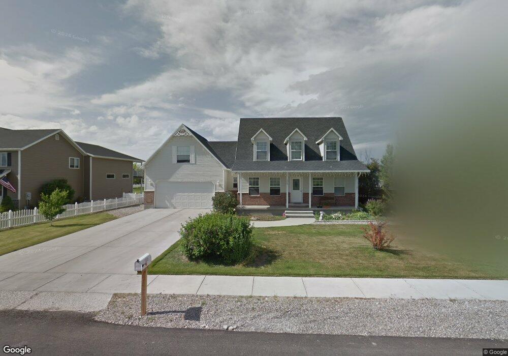
1313 W 350 S Logan, UT 84321
Woodruff NeighborhoodEstimated Value: $462,545 - $513,000
3
Beds
3
Baths
2,003
Sq Ft
$238/Sq Ft
Est. Value
About This Home
This home is located at 1313 W 350 S, Logan, UT 84321 and is currently estimated at $477,636, approximately $238 per square foot. 1313 W 350 S is a home located in Cache County with nearby schools including Woodruff School, Mount Logan Middle School, and Logan High School.
Ownership History
Date
Name
Owned For
Owner Type
Purchase Details
Closed on
Jun 1, 2020
Sold by
Bowen Michael
Bought by
Bowen Michael and Bowen Lisa Michelle
Current Estimated Value
Home Financials for this Owner
Home Financials are based on the most recent Mortgage that was taken out on this home.
Original Mortgage
$150,500
Outstanding Balance
$133,072
Interest Rate
3.3%
Mortgage Type
New Conventional
Estimated Equity
$344,565
Purchase Details
Closed on
Aug 11, 2015
Sold by
Bowen Michael
Bought by
Bowen Michael and Bowen Lisa Michelle
Home Financials for this Owner
Home Financials are based on the most recent Mortgage that was taken out on this home.
Original Mortgage
$185,250
Interest Rate
3.5%
Mortgage Type
Adjustable Rate Mortgage/ARM
Purchase Details
Closed on
Nov 13, 2006
Sold by
Swensen Arla M
Bought by
Vargecko Patrick and Vargecko Sharon S
Home Financials for this Owner
Home Financials are based on the most recent Mortgage that was taken out on this home.
Original Mortgage
$183,920
Interest Rate
6.3%
Mortgage Type
New Conventional
Create a Home Valuation Report for This Property
The Home Valuation Report is an in-depth analysis detailing your home's value as well as a comparison with similar homes in the area
Home Values in the Area
Average Home Value in this Area
Purchase History
| Date | Buyer | Sale Price | Title Company |
|---|---|---|---|
| Bowen Michael | -- | Northern Title Company | |
| Bowen Michael | -- | Northern Title Company | |
| Bowen Michael | -- | Advanced Title | |
| Bowen Michael | -- | Cache Title Logan | |
| Vargecko Patrick | -- | Summit Title & Escrow |
Source: Public Records
Mortgage History
| Date | Status | Borrower | Loan Amount |
|---|---|---|---|
| Open | Bowen Michael | $150,500 | |
| Closed | Bowen Michael | $185,250 | |
| Previous Owner | Vargecko Patrick | $183,920 |
Source: Public Records
Tax History
| Year | Tax Paid | Tax Assessment Tax Assessment Total Assessment is a certain percentage of the fair market value that is determined by local assessors to be the total taxable value of land and additions on the property. | Land | Improvement |
|---|---|---|---|---|
| 2025 | $1,800 | $232,740 | $0 | $0 |
| 2024 | $1,861 | $233,175 | $0 | $0 |
| 2023 | $1,931 | $230,510 | $0 | $0 |
| 2022 | $1,702 | $189,805 | $0 | $0 |
| 2021 | $1,675 | $288,485 | $62,000 | $226,485 |
| 2020 | $1,567 | $242,895 | $62,000 | $180,895 |
| 2019 | $1,638 | $242,895 | $62,000 | $180,895 |
| 2018 | $1,619 | $219,300 | $62,000 | $157,300 |
| 2017 | $1,517 | $108,625 | $0 | $0 |
| 2016 | $1,573 | $108,625 | $0 | $0 |
| 2015 | $1,518 | $104,730 | $0 | $0 |
| 2014 | $1,372 | $104,730 | $0 | $0 |
| 2013 | -- | $104,730 | $0 | $0 |
Source: Public Records
Map
Nearby Homes
- 1312 W 350 S
- 245 S 1280 W
- 1230 W 240 S
- 370 S 1200 W Unit 2
- 1174 W 240 S
- 1177 W 240 S
- 1099 Three Pointe Ave
- 1031 W 350 S
- 1210 W 575 S Unit 163
- 1210 W 575 S
- 1204 W 575 S
- 241 Sunstone Cir
- 952 W 330 S
- 959 Three Pointe Ave
- 1400 S 940 W
- 1506 Silver Canoe Loop
- 539 S 1580 W Unit 121
- 1772 W Rivergate Dr
- 1788 W Rivergate Dr
- 240 N 1375 W Unit 3
Your Personal Tour Guide
Ask me questions while you tour the home.