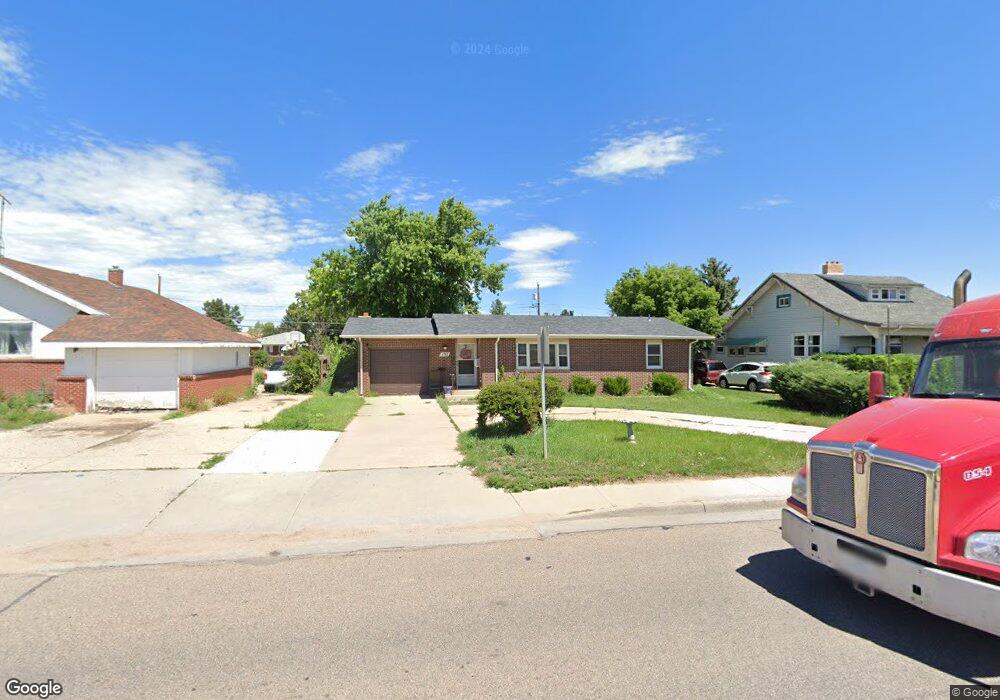
132 Dell Range Blvd Cheyenne, WY 82009
Estimated Value: $364,000 - $435,000
About This Home
This home is located at 132 Dell Range Blvd, Cheyenne, WY 82009 and is currently estimated at $392,425, approximately $284 per square foot. 132 Dell Range Blvd is a home located in Laramie County with nearby schools including Hobbs Elementary School, McCormick Junior High School, and Central High School.
Ownership History
We collect this data history from publicly available records. To have your information removed, we recommend requesting removal directly through your county’s website.
Purchase Details
Home Financials for this Owner
Home Financials are based on the most recent Mortgage that was taken out on this home.Purchase Details
Home Financials for this Owner
Home Financials are based on the most recent Mortgage that was taken out on this home.Purchase Details
Home Financials for this Owner
Home Financials are based on the most recent Mortgage that was taken out on this home.Purchase Details
Purchase Details
Purchase Details
Home Financials for this Owner
Home Financials are based on the most recent Mortgage that was taken out on this home.Purchase Details
Home Financials for this Owner
Home Financials are based on the most recent Mortgage that was taken out on this home.Purchase History
We collect this data history from publicly available records. To have your information removed, we recommend requesting removal directly through your county’s website.
| Date | Buyer | Sale Price | Title Company |
|---|---|---|---|
| -- | None Available | ||
| -- | -- | ||
| -- | -- | ||
| $114,571 | -- | ||
| $114,571 | -- | ||
| -- | -- | ||
| -- | -- |
Mortgage History
We collect this data history from publicly available records. To have your information removed, we recommend requesting removal directly through your county’s website.
| Date | Status | Borrower | Loan Amount |
|---|---|---|---|
| Open | $116,400 | ||
| Previous Owner | $98,000 | ||
| Previous Owner | $24,500 | ||
| Previous Owner | $106,250 | ||
| Previous Owner | $87,218 | ||
| Closed | $4,150 |
Tax History
We collect this data history from publicly available records. To have your information removed, we recommend requesting removal directly through your county’s website.
| Year | Tax Paid | Tax Assessment Tax Assessment Total Assessment is a certain percentage of the fair market value that is determined by local assessors to be the total taxable value of land and additions on the property. | Land | Improvement |
|---|---|---|---|---|
| 2025 | $1,754 | $24,868 | $3,227 | $21,641 |
| 2024 | $2,259 | $31,952 | $4,303 | $27,649 |
| 2023 | $2,189 | $30,959 | $4,303 | $26,656 |
| 2022 | $2,129 | $29,500 | $4,303 | $25,197 |
| 2021 | $1,860 | $25,711 | $4,303 | $21,408 |
| 2020 | $1,805 | $25,027 | $4,303 | $20,724 |
| 2019 | $1,689 | $23,399 | $4,303 | $19,096 |
| 2018 | $1,541 | $21,542 | $3,853 | $17,689 |
| 2017 | $1,539 | $21,323 | $3,853 | $17,470 |
| 2016 | $1,393 | $19,289 | $3,594 | $15,695 |
| 2015 | $1,303 | $18,036 | $3,594 | $14,442 |
| 2014 | $1,181 | $16,252 | $3,594 | $12,658 |
Map
- 208 Dell Range Blvd
- 5217 Fawn Pass
- 5245 Fishing Bridge
- 338 Manewal Dr
- 5434 Sunset Dr
- 5417 Frederick Dr
- 457 Andra Ct
- 518 Andra Ct
- 247 Miller Ln
- 731 Melton St
- 5441 Hynds Blvd
- 721 Arapaho St
- 1454 Trent Ct
- 422 Brandi Ln
- TBD E Carlson St
- 5907 Townsend Place
- Lot 12 Hynds Blvd
- Lot 8 Hynds Blvd
- 5419 Hynds Blvd
- 5110 Syracuse Rd
- 128 Dell Range Blvd
- 138 Dell Range Blvd
- 146 Dell Range Blvd
- 120 Dell Range Blvd
- 127 Carroll Ave
- 137 Carroll Ave
- 5000 Sunset Dr
- 145 Carroll Ave
- 149 Carroll Ave
- 113 Carroll Ave
- 200 Dell Range Blvd
- 5015 Yellowstone Rd
- 132 Carroll Ave
- 138 Carroll Ave
- 128 Carroll Ave
- 203 Carroll Ave
- 105 Carroll Ave
- 146 Carroll Ave
- 120 Carroll Ave
- 150 Carroll Ave
Ask me questions while you tour the home.