132 Wadhams Rd Bloomfield, CT 06002
Estimated Value: $478,000 - $571,000
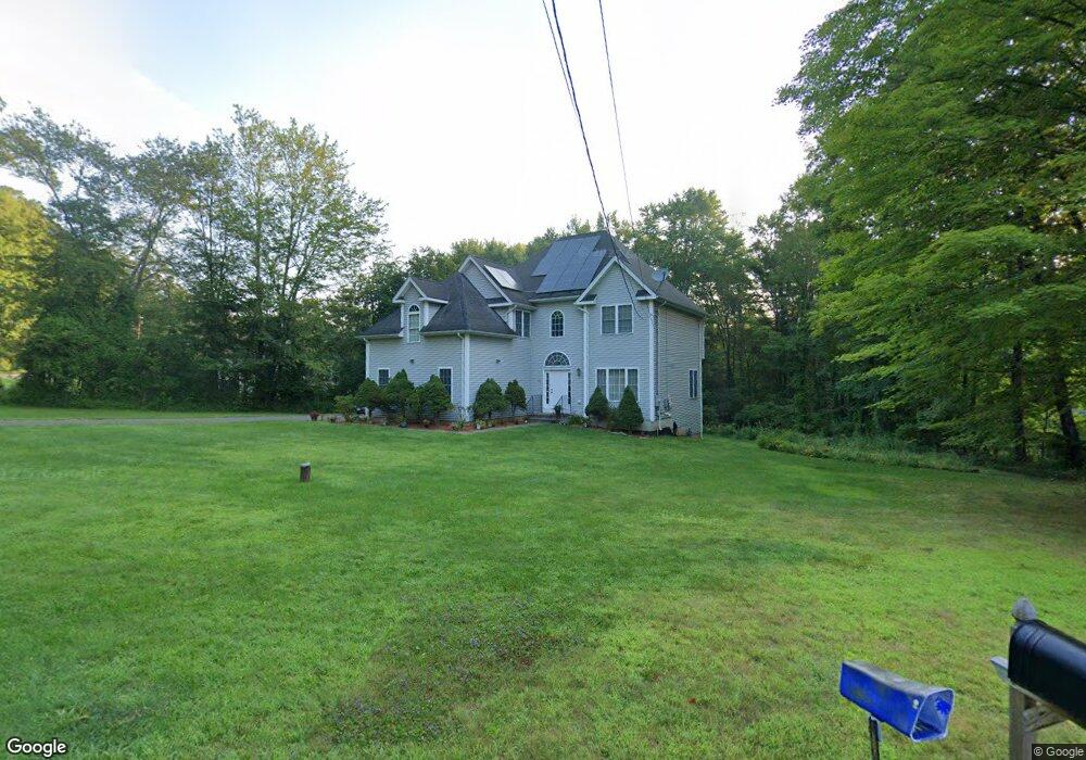
About This Home
This home is located at 132 Wadhams Rd, Bloomfield, CT 06002 and is currently estimated at $518,463, approximately $230 per square foot. 132 Wadhams Rd is a home located in Hartford County with nearby schools including Laurel School, Carmen Arace Intermediate School, and Metacomet School.
Ownership History
We collect this data history from publicly available records. To have your information removed, we recommend requesting removal directly through your county’s website.
Purchase Details
Home Financials for this Owner
Home Financials are based on the most recent Mortgage that was taken out on this home.Home Values in the Area
Average Home Value in this Area
Purchase History
We collect this data history from publicly available records. To have your information removed, we recommend requesting removal directly through your county’s website.
| Date | Buyer | Sale Price | Title Company |
|---|---|---|---|
| $319,900 | -- | ||
| $319,900 | -- |
Mortgage History
We collect this data history from publicly available records. To have your information removed, we recommend requesting removal directly through your county’s website.
| Date | Status | Borrower | Loan Amount |
|---|---|---|---|
| Open | $239,925 | ||
| Closed | $47,985 | ||
| Closed | $239,925 |
Tax History
We collect this data history from publicly available records. To have your information removed, we recommend requesting removal directly through your county’s website.
| Year | Tax Paid | Tax Assessment Tax Assessment Total Assessment is a certain percentage of the fair market value that is determined by local assessors to be the total taxable value of land and additions on the property. | Land | Improvement |
|---|---|---|---|---|
| 2025 | $11,406 | $304,150 | $57,120 | $247,030 |
| 2024 | $8,018 | $204,330 | $47,950 | $156,380 |
| 2023 | $7,873 | $204,330 | $47,950 | $156,380 |
| 2022 | $7,362 | $204,330 | $47,950 | $156,380 |
| 2021 | $7,525 | $204,330 | $47,950 | $156,380 |
| 2020 | $7,409 | $204,330 | $47,950 | $156,380 |
| 2019 | $7,843 | $202,860 | $47,950 | $154,910 |
| 2018 | $8,202 | $212,380 | $48,580 | $163,800 |
| 2017 | $8,189 | $212,380 | $48,580 | $163,800 |
| 2016 | $7,996 | $212,380 | $48,580 | $163,800 |
| 2015 | $7,847 | $212,380 | $48,580 | $163,800 |
| 2014 | $8,168 | $228,550 | $51,030 | $177,520 |
Map
- 10 Quail Run
- 22 Terry Plains Rd
- 257 Tunxis Ave
- 22 Walts Hill
- 10 Penwood Rd
- 406 Tunxis Ave
- 174 Thistle Pond Dr Unit 174
- 20 Reed Ct Unit 20
- 18 Richard Ln
- 78 Silo Way
- 7 Jonathan Place
- 6 Boysen Dr
- 226 Woodland Ave
- 2 Schuyler Ln
- 218 Woodland Ave
- 24 Hunting Ridge Dr
- 16 Pinnacle Mountain Rd
- 10 Linden Ct Unit 10
- 16 Harvest Ln
- 19 Brighton Park Way Unit 19
- 134 Wadhams Rd
- 136 Wadhams Rd
- 130 Wadhams Rd
- 10 Worthington Dr
- 140 Wadhams Rd
- 8 Worthington Dr
- 133 Wadhams Rd
- 12 Worthington Dr
- 12 Worthington Dr Unit 12
- 131 Wadhams Rd
- 128 Wadhams Rd
- 2 Butternut Dr
- 6 Worthington Dr
- 14 Worthington Dr
- 142 Wadhams Rd
- 126 Wadhams Rd
- 4 Butternut Dr
- 6 Cedar Ln
- 4 Worthington Dr
- 4 Cedar Ln
Ask me questions while you tour the home.