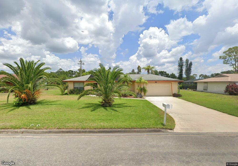
133 Brookside St Unit 1 Lehigh Acres, FL 33936
Eisenhower NeighborhoodEstimated Value: $226,000 - $268,000
2
Beds
1
Bath
1,203
Sq Ft
$202/Sq Ft
Est. Value
About This Home
This home is located at 133 Brookside St Unit 1, Lehigh Acres, FL 33936 and is currently estimated at $242,508, approximately $201 per square foot. 133 Brookside St Unit 1 is a home located in Lee County with nearby schools including Lehigh Elementary School, The Alva School, and Gateway Elementary School.
Ownership History
Date
Name
Owned For
Owner Type
Purchase Details
Closed on
Jul 19, 2019
Sold by
Luciani Helen and Strzalkowski Helen Elizabeth
Bought by
Luciani Helen and Lloyd Erik Stephen
Current Estimated Value
Purchase Details
Closed on
Jul 9, 2019
Sold by
Luciani Anthony
Bought by
Luciani Helen
Purchase Details
Closed on
Jul 31, 2009
Sold by
Coates Jeanne M
Bought by
Luciani Anthony and Luciani Helen
Purchase Details
Closed on
Feb 21, 2006
Sold by
Coates Jeanne M
Bought by
Coates Jeanne M and Jeanne M Coates Revocable Trust
Create a Home Valuation Report for This Property
The Home Valuation Report is an in-depth analysis detailing your home's value as well as a comparison with similar homes in the area
Home Values in the Area
Average Home Value in this Area
Purchase History
| Date | Buyer | Sale Price | Title Company |
|---|---|---|---|
| Luciani Helen | -- | Attorney | |
| Luciani Helen | -- | Attorney | |
| Luciani Anthony | $70,000 | Title Group Of Fort Myers Lt | |
| Coates Jeanne M | -- | None Available |
Source: Public Records
Tax History
| Year | Tax Paid | Tax Assessment Tax Assessment Total Assessment is a certain percentage of the fair market value that is determined by local assessors to be the total taxable value of land and additions on the property. | Land | Improvement |
|---|---|---|---|---|
| 2025 | $3,131 | $195,900 | $23,418 | $172,482 |
| 2024 | $2,856 | $180,752 | -- | -- |
| 2023 | $2,856 | $164,320 | $0 | $0 |
| 2022 | $2,594 | $149,382 | $0 | $0 |
| 2021 | $2,253 | $135,802 | $9,450 | $126,352 |
| 2020 | $2,158 | $125,161 | $9,000 | $116,161 |
| 2019 | $2,023 | $119,517 | $8,000 | $111,517 |
| 2018 | $1,895 | $108,208 | $7,500 | $100,708 |
| 2017 | $1,769 | $97,711 | $7,500 | $90,211 |
| 2016 | $1,629 | $84,811 | $7,500 | $77,311 |
| 2015 | $1,510 | $74,797 | $6,300 | $68,497 |
| 2014 | -- | $66,901 | $3,950 | $62,951 |
| 2013 | -- | $56,009 | $2,700 | $53,309 |
Source: Public Records
Map
Nearby Homes
- 26 Michigan Rd
- 14 Richmond Ave N
- 514 Pennview Ave
- 15 Maryland Rd
- 21 Maryland Rd
- 1217 Clayton Ave
- 1604 Clayton Ave
- 110 Texas Rd
- 108 Coolidge Ave
- 18 Illinois Rd
- 406 Leeland Heights Blvd E
- 112 Clayton Ave
- 12 Calvin Ave
- 56 Illinois Rd
- 19 Illinois Rd
- 213 Richmond Ave S
- 117 Coolidge Ave
- 32 Lincoln Ave
- 23 Louisiana Rd
- 10 E Jersey Rd
- 131 Brookside St
- 135 Brookside St
- 134 Brookside St
- 132 Brookside St
- 137 Brookside St
- 129 Brookside St
- 11 Clayton Ave Unit 13
- 11 Clayton Ave
- 136 Brookside St
- 130 Brookside St
- 139 Brookside St
- 138 Brookside St
- 123 Oakside St
- 100 Airview Ave
- 125 Oakside St
- 13 Clayton Ave
- 13 Clayton Ave Unit 14
- 105 Airview Ave
- 102 Airview Ave
- 239 Brookside St
Your Personal Tour Guide
Ask me questions while you tour the home.