Estimated Value: $277,346 - $289,000
3
Beds
2
Baths
1,750
Sq Ft
$161/Sq Ft
Est. Value
About This Home
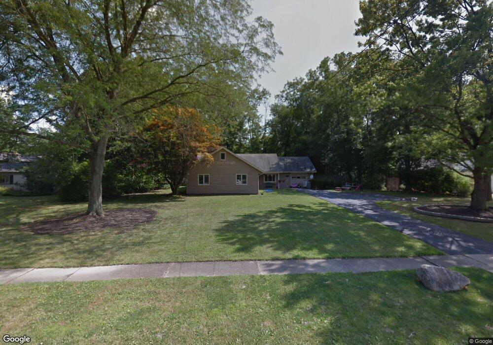
This home is located at 133 Manning Dr, Berea, OH 44017 and is currently estimated at $281,087, approximately $160 per square foot. 133 Manning Dr is a home located in Cuyahoga County with nearby schools including Grindstone Elementary School, Berea-Midpark Middle School, and Berea-Midpark High School.
Ownership History
Date
Name
Owned For
Owner Type
Purchase Details
Closed on
Aug 14, 2003
Sold by
Damico Michael T and Damico Jennifer A
Bought by
Wooten Marshal and Myers Melissa J
Current Estimated Value
Home Financials for this Owner
Home Financials are based on the most recent Mortgage that was taken out on this home.
Original Mortgage
$156,750
Outstanding Balance
$65,514
Interest Rate
5.62%
Mortgage Type
Purchase Money Mortgage
Estimated Equity
$215,573
Purchase Details
Closed on
Jul 15, 1992
Sold by
Maloney Wm J
Bought by
Lucas Dorothy G
Purchase Details
Closed on
Jan 1, 1975
Bought by
Maloney Wm J
Create a Home Valuation Report for This Property
The Home Valuation Report is an in-depth analysis detailing your home's value as well as a comparison with similar homes in the area
Home Values in the Area
Average Home Value in this Area
Purchase History
We collect this data history from publicly available records. To have your information removed, we recommend requesting removal directly through your county’s website.
| Date | Buyer | Sale Price | Title Company |
|---|---|---|---|
| Wooten Marshal | $165,000 | Premier Title | |
| Lucas Dorothy G | $105,000 | -- | |
| Maloney Wm J | -- | -- |
Source: Public Records
Mortgage History
We collect this data history from publicly available records. To have your information removed, we recommend requesting removal directly through your county’s website.
| Date | Status | Borrower | Loan Amount |
|---|---|---|---|
| Open | Wooten Marshal | $156,750 |
Source: Public Records
Tax History
| Year | Tax Paid | Tax Assessment Tax Assessment Total Assessment is a certain percentage of the fair market value that is determined by local assessors to be the total taxable value of land and additions on the property. | Land | Improvement |
|---|---|---|---|---|
| 2025 | $5,224 | $90,195 | $21,735 | $68,460 |
| 2024 | $5,212 | $90,195 | $21,735 | $68,460 |
| 2023 | $4,405 | $63,780 | $17,610 | $46,170 |
| 2022 | $4,377 | $63,770 | $17,610 | $46,170 |
| 2021 | $4,340 | $63,770 | $17,610 | $46,170 |
| 2020 | $6,733 | $54,040 | $14,910 | $39,130 |
| 2019 | $4,035 | $154,400 | $42,600 | $111,800 |
| 2018 | $3,700 | $54,040 | $14,910 | $39,130 |
| 2017 | $3,638 | $45,470 | $19,810 | $25,660 |
| 2016 | $3,611 | $45,470 | $19,810 | $25,660 |
| 2015 | $3,591 | $45,470 | $19,810 | $25,660 |
| 2014 | $3,591 | $47,850 | $20,860 | $26,990 |
Source: Public Records
Map
Nearby Homes
- 165 Dorland Ave
- 262 Stanmary Dr
- 20598 Homestead Park Dr
- 7679 S Eastland Rd
- 9207 Prospect Rd
- 7640 S Eastland Rd
- 8036 Fair Rd
- 80 Hamilton St
- 9753 Prospect Rd
- 8760 Priem Rd
- 233 Baldwin Dr
- 11035 Steven David Dr
- 9981 Woodhurst Dr
- 8345 Celianna Dr
- 21032 Breckenridge Ln
- 50 S Rocky River Dr Unit 705
- 8902 Lincolnshire Blvd
- 142 E Bridge St
- 10108 Fair Rd
- 329 Baldwin Dr
Your Personal Tour Guide
Ask me questions while you tour the home.