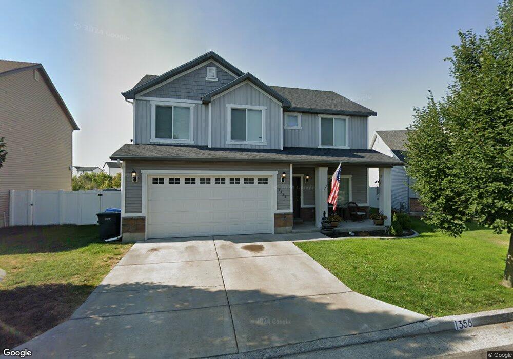
1358 W 1925 S Logan, UT 84321
Woodruff NeighborhoodEstimated Value: $421,000 - $442,000
4
Beds
3
Baths
1,841
Sq Ft
$235/Sq Ft
Est. Value
About This Home
This home is located at 1358 W 1925 S, Logan, UT 84321 and is currently estimated at $431,799, approximately $234 per square foot. 1358 W 1925 S is a home located in Cache County with nearby schools including Woodruff School, Mount Logan Middle School, and Logan High School.
Ownership History
Date
Name
Owned For
Owner Type
Purchase Details
Closed on
Jul 9, 2020
Sold by
Fisher Jason A
Bought by
Fisher Jason A and Fisher Jacee
Current Estimated Value
Home Financials for this Owner
Home Financials are based on the most recent Mortgage that was taken out on this home.
Original Mortgage
$290,000
Outstanding Balance
$256,579
Interest Rate
3.1%
Mortgage Type
VA
Estimated Equity
$175,220
Purchase Details
Closed on
Aug 29, 2018
Sold by
Campbell Michael D and Campbell Ashley A
Bought by
Pena Ivan
Home Financials for this Owner
Home Financials are based on the most recent Mortgage that was taken out on this home.
Original Mortgage
$240,825
Interest Rate
4.5%
Mortgage Type
New Conventional
Purchase Details
Closed on
Jul 11, 2016
Sold by
Workman Steven and Workman Rachel
Bought by
Campbell Michael D and Campbell Ashley A
Home Financials for this Owner
Home Financials are based on the most recent Mortgage that was taken out on this home.
Original Mortgage
$189,256
Interest Rate
3.41%
Mortgage Type
FHA
Purchase Details
Closed on
Dec 20, 2012
Sold by
Kartchner Homes Cvdivision Inc
Bought by
Workman Steven and Workman Rachel
Home Financials for this Owner
Home Financials are based on the most recent Mortgage that was taken out on this home.
Original Mortgage
$141,852
Interest Rate
3.37%
Mortgage Type
New Conventional
Purchase Details
Closed on
Sep 18, 2012
Sold by
Continental Development Inc
Bought by
Kartchner Homes Cvdivision Inc
Home Financials for this Owner
Home Financials are based on the most recent Mortgage that was taken out on this home.
Original Mortgage
$102,462
Interest Rate
3.55%
Mortgage Type
Construction
Purchase Details
Closed on
Dec 28, 2007
Sold by
Rosehill Llc
Bought by
Continental Development Inc
Home Financials for this Owner
Home Financials are based on the most recent Mortgage that was taken out on this home.
Original Mortgage
$422,625
Interest Rate
10%
Mortgage Type
Seller Take Back
Create a Home Valuation Report for This Property
The Home Valuation Report is an in-depth analysis detailing your home's value as well as a comparison with similar homes in the area
Home Values in the Area
Average Home Value in this Area
Purchase History
| Date | Buyer | Sale Price | Title Company |
|---|---|---|---|
| Fisher Jason A | -- | Cache Title Logan | |
| Fisher Jason A | -- | Cache Title Logan | |
| Pena Ivan | -- | Advantage Title Insurance Ag | |
| Campbell Michael D | -- | American Secure Title Logan | |
| Workman Steven | -- | Cache Title Company | |
| Kartchner Homes Cvdivision Inc | -- | Cache Title Company | |
| Continental Development Inc | -- | Cache Title Company |
Source: Public Records
Mortgage History
| Date | Status | Borrower | Loan Amount |
|---|---|---|---|
| Open | Fisher Jason A | $290,000 | |
| Previous Owner | Pena Ivan | $240,825 | |
| Previous Owner | Campbell Michael D | $189,256 | |
| Previous Owner | Workman Steven | $141,852 | |
| Previous Owner | Kartchner Homes Cvdivision Inc | $102,462 | |
| Previous Owner | Continental Development Inc | $422,625 |
Source: Public Records
Tax History
| Year | Tax Paid | Tax Assessment Tax Assessment Total Assessment is a certain percentage of the fair market value that is determined by local assessors to be the total taxable value of land and additions on the property. | Land | Improvement |
|---|---|---|---|---|
| 2025 | $176 | $227,845 | $0 | $0 |
| 2024 | $1,809 | $226,610 | $0 | $0 |
| 2023 | $1,878 | $224,235 | $0 | $0 |
| 2022 | $2,011 | $224,235 | $0 | $0 |
| 2021 | $1,564 | $269,491 | $55,000 | $214,491 |
| 2020 | $1,558 | $241,514 | $55,000 | $186,514 |
| 2019 | $1,628 | $241,513 | $55,000 | $186,513 |
| 2018 | $1,488 | $201,530 | $35,000 | $166,530 |
| 2017 | $1,487 | $106,480 | $0 | $0 |
| 2016 | $1,542 | $97,570 | $0 | $0 |
| 2015 | $1,414 | $97,570 | $0 | $0 |
| 2014 | $1,279 | $97,570 | $0 | $0 |
| 2013 | -- | $95,645 | $0 | $0 |
Source: Public Records
Map
Nearby Homes
- 1913 S 1325 W
- 2011 Wren Cir
- 1249 W 1820 S
- 1247 W 1820 S
- 1219 W 1870 S
- 1387 W 1825 S
- 1230 W 1820 S
- 1195 W 1870 S
- 1219 W 1820 S
- 1145 W 2000 S
- 2124 S 1490 W
- 2242 S 1120 W Unit 69
- 2254 S 1120 W Unit 72
- 2250 S 1120 W Unit 71
- 2258 S 1120 W Unit 73
- 2246 S 1120 W Unit 70
- 1975 S 1100 W
- 1532 W 2150 S
- 2174 S 1450 W
- 1430 W 2200 S
- 1358 W 1925 S Unit 32
- 1342 W 1925 S
- 1364 W 1925 S
- 1336 W 1925 S
- 1919 S 1365 W
- 1359 W 1925 S
- 1347 W 1925 S Unit 40
- 1911 S 1365 W
- 1328 W 1925 S
- 1907 S 1325 W
- 1905 S 1365 W
- 1362 W 1900 S Unit 38
- 1362 W 1900 S
- 1354 W 1900 S
- 1918 S 1325 W
- 1903 S 1325 W
- 1914 S 1325 W
- 1901 S 1365 W
- 1918 S 1395 W
- 1908 S 1325 W
Your Personal Tour Guide
Ask me questions while you tour the home.