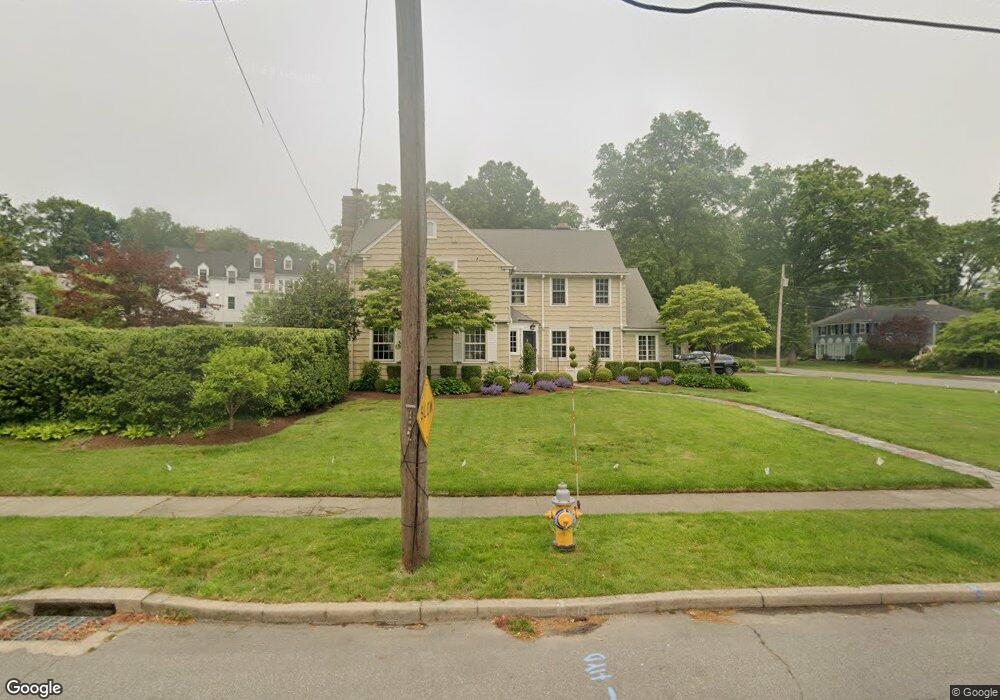
136 Algonquin Rd Fairfield, CT 06825
Stratfield Village NeighborhoodEstimated Value: $1,172,359 - $1,294,000
5
Beds
5
Baths
3,810
Sq Ft
$322/Sq Ft
Est. Value
About This Home
This home is located at 136 Algonquin Rd, Fairfield, CT 06825 and is currently estimated at $1,228,590, approximately $322 per square foot. 136 Algonquin Rd is a home located in Fairfield County with nearby schools including Stratfield Elementary School, Tomlinson Middle School, and Fairfield Warde High School.
Ownership History
Date
Name
Owned For
Owner Type
Purchase Details
Closed on
May 5, 2004
Sold by
Palermo Tari J
Bought by
Hessel Stephen C and Hessel Megan G
Current Estimated Value
Home Financials for this Owner
Home Financials are based on the most recent Mortgage that was taken out on this home.
Original Mortgage
$484,000
Interest Rate
5.39%
Create a Home Valuation Report for This Property
The Home Valuation Report is an in-depth analysis detailing your home's value as well as a comparison with similar homes in the area
Home Values in the Area
Average Home Value in this Area
Purchase History
We collect this data history from publicly available records. To have your information removed, we recommend requesting removal directly through your county’s website.
| Date | Buyer | Sale Price | Title Company |
|---|---|---|---|
| Hessel Stephen C | $760,000 | -- | |
| Hessel Stephen C | $760,000 | -- |
Source: Public Records
Mortgage History
We collect this data history from publicly available records. To have your information removed, we recommend requesting removal directly through your county’s website.
| Date | Status | Borrower | Loan Amount |
|---|---|---|---|
| Open | Hessel Stephen C | $417,000 | |
| Closed | Hessel Stephen C | $484,000 | |
| Previous Owner | Hessel Stephen C | $233,000 |
Source: Public Records
Tax History
| Year | Tax Paid | Tax Assessment Tax Assessment Total Assessment is a certain percentage of the fair market value that is determined by local assessors to be the total taxable value of land and additions on the property. | Land | Improvement |
|---|---|---|---|---|
| 2025 | $13,645 | $480,620 | $241,430 | $239,190 |
| 2024 | $13,409 | $480,620 | $241,430 | $239,190 |
| 2023 | $13,222 | $480,620 | $241,430 | $239,190 |
| 2022 | $13,092 | $480,620 | $241,430 | $239,190 |
| 2021 | $12,967 | $480,620 | $241,430 | $239,190 |
| 2020 | $13,341 | $497,980 | $207,480 | $290,500 |
| 2019 | $13,341 | $497,980 | $207,480 | $290,500 |
| 2018 | $13,127 | $497,980 | $207,480 | $290,500 |
| 2017 | $12,858 | $497,980 | $207,480 | $290,500 |
| 2016 | $12,674 | $497,980 | $207,480 | $290,500 |
| 2015 | $12,777 | $515,410 | $273,000 | $242,410 |
| 2014 | $12,576 | $515,410 | $273,000 | $242,410 |
Source: Public Records
Map
Nearby Homes
- 20 Lynnbrook Rd
- 252 Villa Ave
- 273 Brooklawn Ave
- 324 Villa Ave
- 47 Lewis Dr
- 131 Aldine Ave
- 135 Laurel Place
- 16 Lookout Dr N
- 1479 Laurel Ave
- 860 Briarwood Ave
- 1210 Laurel Ave
- 26 Essex St
- 25 Essex St
- 65 Brooklawn Place
- 80 Cartright St Unit PHA
- 1213 Wood Ave
- 2370 North Ave Unit 4C
- 25 Cartright St Unit 7E
- 25 Cartright St Unit 5D
- 2660 North Ave Unit 112
- 168 Algonquin Rd
- 147 Algonquin Rd
- 131 Algonquin Rd
- 321 Collingwood Ave
- 171 Algonquin Rd
- 35 Pequot Rd
- 14 Pequot Rd
- 36 Pequot Rd
- 340 Collingwood Ave
- 87 Sachem Rd
- 91 Algonquin Rd Unit SI FL3-ID1262033P
- 91 Algonquin Rd Unit FL3-ID1262033P
- 91 Algonquin Rd Unit ID1262033P
- 201 Algonquin Rd
- 52 Algonquin Rd
- 318 Collingwood Ave
- 67 Sachem Rd
- 150 Villa Ave
- 233 Algonquin Rd
- 256 Villa Ave Unit 3RD F
Your Personal Tour Guide
Ask me questions while you tour the home.