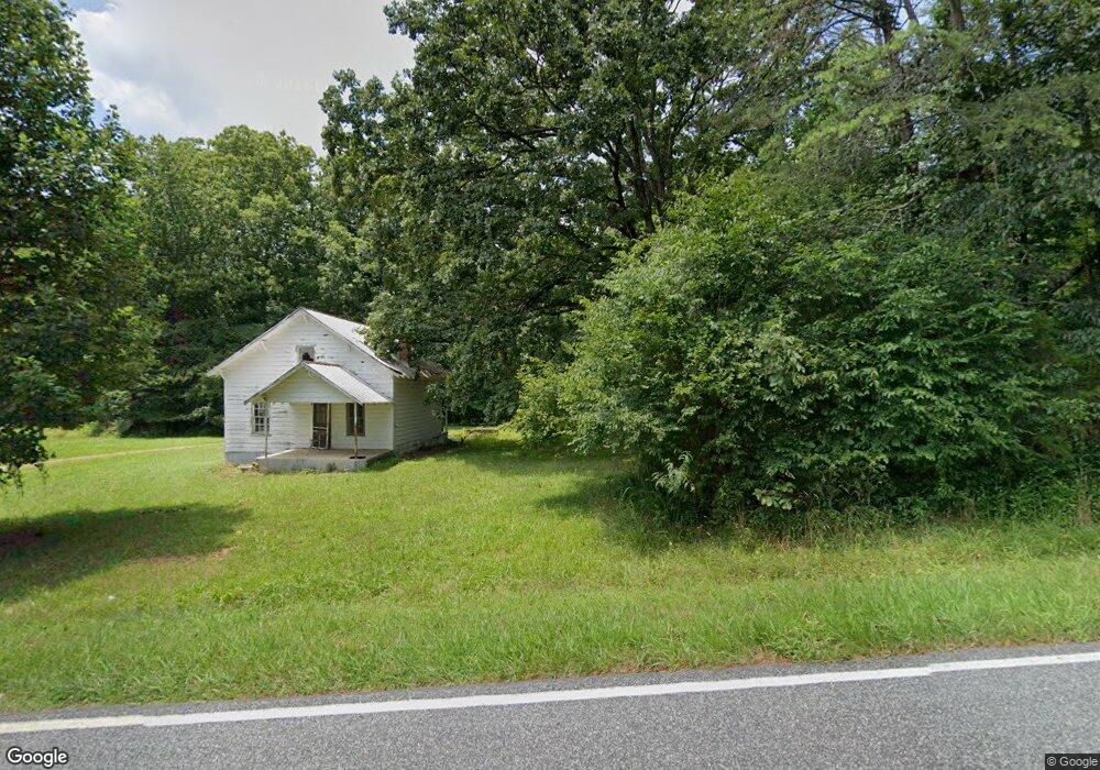
1379 Smith Rd Westfield, NC 27053
Estimated Value: $306,000 - $408,000
3
Beds
2
Baths
2,128
Sq Ft
$173/Sq Ft
Est. Value
About This Home
This home is located at 1379 Smith Rd, Westfield, NC 27053 and is currently estimated at $369,190, approximately $173 per square foot. 1379 Smith Rd is a home located in Stokes County with nearby schools including Nancy Reynolds Elementary School, Piney Grove Middle, and North Stokes High.
Ownership History
Date
Name
Owned For
Owner Type
Purchase Details
Closed on
Jul 30, 2024
Sold by
Moorefield Michael R and Moorefield Christian J
Bought by
Feldsine Donald
Current Estimated Value
Purchase Details
Closed on
Feb 25, 2010
Sold by
Holshouser Billy M
Bought by
Moorefield Michael R and Moorefield Christian J
Home Financials for this Owner
Home Financials are based on the most recent Mortgage that was taken out on this home.
Original Mortgage
$152,041
Interest Rate
5%
Mortgage Type
New Conventional
Purchase Details
Closed on
Feb 17, 2010
Sold by
Holshouser Sarah K
Bought by
Moorefield Michael R and Moorefield Christian J
Home Financials for this Owner
Home Financials are based on the most recent Mortgage that was taken out on this home.
Original Mortgage
$152,041
Interest Rate
5%
Mortgage Type
New Conventional
Create a Home Valuation Report for This Property
The Home Valuation Report is an in-depth analysis detailing your home's value as well as a comparison with similar homes in the area
Purchase History
| Date | Buyer | Sale Price | Title Company |
|---|---|---|---|
| Feldsine Donald | $368,500 | None Listed On Document | |
| Moorefield Michael R | $150,000 | Atc | |
| Moorefield Michael R | -- | Atc |
Source: Public Records
Mortgage History
| Date | Status | Borrower | Loan Amount |
|---|---|---|---|
| Previous Owner | Moorefield Michael R | $152,041 |
Source: Public Records
Tax History
| Year | Tax Paid | Tax Assessment Tax Assessment Total Assessment is a certain percentage of the fair market value that is determined by local assessors to be the total taxable value of land and additions on the property. | Land | Improvement |
|---|---|---|---|---|
| 2025 | $2,635 | $368,500 | $40,100 | $328,400 |
| 2024 | $2,635 | $177,300 | $29,600 | $147,700 |
| 2023 | $1,436 | $177,300 | $29,600 | $147,700 |
| 2022 | $1,312 | $177,300 | $29,600 | $147,700 |
| 2021 | $1,312 | $177,300 | $29,600 | $147,700 |
| 2020 | $1,164 | $157,300 | $28,600 | $128,700 |
| 2019 | $1,164 | $157,300 | $28,600 | $128,700 |
| 2018 | $1,164 | $157,300 | $28,600 | $128,700 |
| 2017 | $1,138 | $154,800 | $28,600 | $126,200 |
| 2016 | $1,103 | $150,000 | $28,600 | $121,400 |
| 2015 | $1,095 | $150,000 | $28,600 | $121,400 |
| 2014 | $1,092 | $150,000 | $28,600 | $121,400 |
Source: Public Records
Map
Nearby Homes
- 1089 Smith Rd
- 3364 Nc 66 Hwy N
- 3673 N Carolina 66
- 1024 Frans Rd
- 1561 Horseshoe Rd
- 1119 Brown Mountain Rd
- 00 Jackson Rd
- 0 Dearmin Rd Unit 1210255
- 0 Dearmin Rd Unit 1198608
- 1019-11 George Rd
- 1019-12 George Rd
- 1019-3 George Rd
- 00 Locust Grove Rd Unit 4
- 00 Locust Grove Rd Unit 2
- 00 Locust Grove Rd Unit 3
- 1135 Daisy Creek Farm Rd
- 0 Locust Grove Rd
- 1928 Frye Rd
- 6071 N Carolina 89
- 1661 King Rd
Your Personal Tour Guide
Ask me questions while you tour the home.