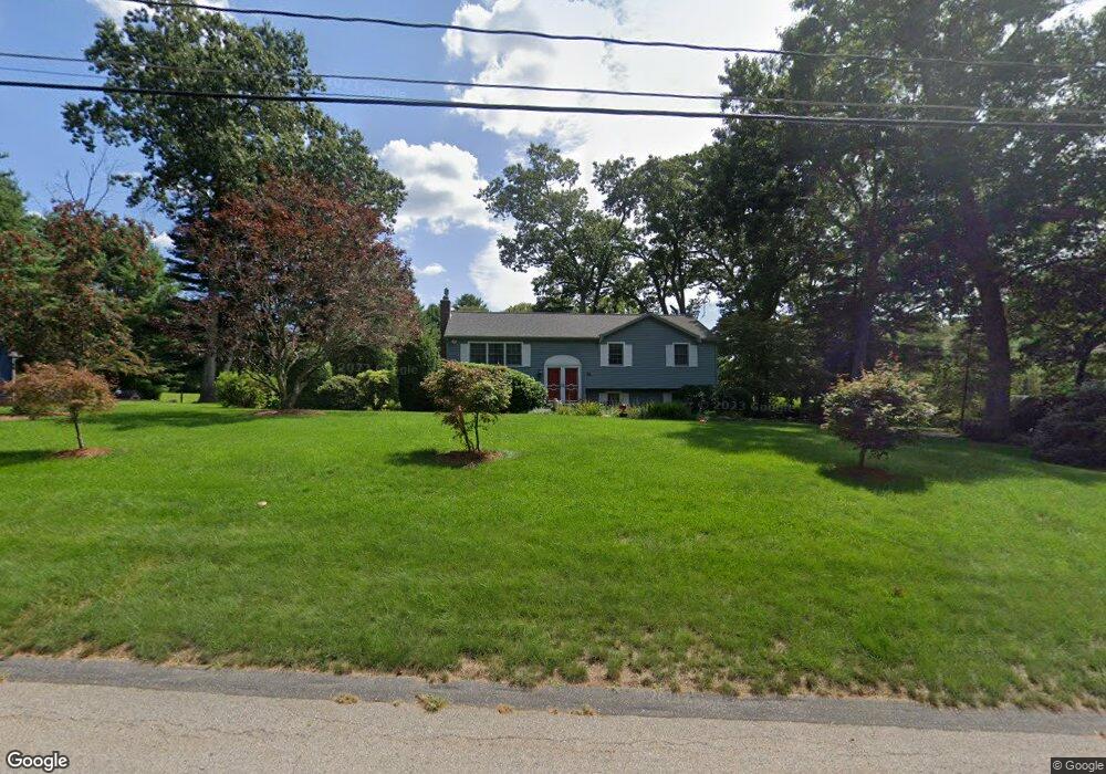
14 Pondview Rd Norfolk, MA 02056
Estimated Value: $626,590 - $717,000
3
Beds
2
Baths
1,391
Sq Ft
$492/Sq Ft
Est. Value
About This Home
This home is located at 14 Pondview Rd, Norfolk, MA 02056 and is currently estimated at $684,398, approximately $492 per square foot. 14 Pondview Rd is a home located in Norfolk County with nearby schools including H. Olive Day School, Freeman-Kennedy School, and Woodside Montessori Academy.
Ownership History
Date
Name
Owned For
Owner Type
Purchase Details
Closed on
Apr 11, 2022
Sold by
Wesalowski Philip A and Wesalowski Catherine A
Bought by
Philip A Wesalowski Ret
Current Estimated Value
Purchase Details
Closed on
Jun 17, 1985
Bought by
Wesalowski Philip A
Create a Home Valuation Report for This Property
The Home Valuation Report is an in-depth analysis detailing your home's value as well as a comparison with similar homes in the area
Home Values in the Area
Average Home Value in this Area
Purchase History
| Date | Buyer | Sale Price | Title Company |
|---|---|---|---|
| Philip A Wesalowski Ret | -- | None Available | |
| Wesalowski Philip A | $149,900 | -- |
Source: Public Records
Mortgage History
| Date | Status | Borrower | Loan Amount |
|---|---|---|---|
| Previous Owner | Wesalowski Philip A | $97,000 |
Source: Public Records
Tax History
| Year | Tax Paid | Tax Assessment Tax Assessment Total Assessment is a certain percentage of the fair market value that is determined by local assessors to be the total taxable value of land and additions on the property. | Land | Improvement |
|---|---|---|---|---|
| 2025 | $8,921 | $558,600 | $213,600 | $345,000 |
| 2024 | $8,171 | $524,800 | $213,600 | $311,200 |
| 2023 | $8,125 | $495,100 | $213,600 | $281,500 |
| 2022 | $8,367 | $459,700 | $199,800 | $259,900 |
| 2021 | $7,809 | $434,100 | $194,100 | $240,000 |
| 2020 | $7,344 | $394,000 | $176,400 | $217,600 |
| 2019 | $6,904 | $377,500 | $176,400 | $201,100 |
| 2018 | $6,480 | $348,000 | $176,400 | $171,600 |
| 2017 | $6,388 | $350,600 | $176,400 | $174,200 |
| 2016 | $6,234 | $344,800 | $176,400 | $168,400 |
| 2015 | $6,079 | $344,200 | $168,000 | $176,200 |
| 2014 | $6,041 | $346,600 | $168,000 | $178,600 |
Source: Public Records
Map
Nearby Homes
- 7 Old Colony Dr
- 1 Margauxs Way
- 40 Medway St
- 3 Elliot Mills Unit 2
- 6 Elliot Mills Unit 31
- 98 Medway St
- 118 Main St
- 57 Thomas Mann Cir Unit Lot 33
- 37 Thomas Mann Cir Unit 23
- 44 Thomas Mann Cir Unit 40
- 35 Thomas Mann Cir Unit 22
- 45 Meetinghouse Rd Unit 45
- 12 Brookside Ln
- 18 Keeney Pond Rd
- 215 Causeway St
- 234-236-0 Pleasant St
- 12 Ariana Ln
- 7 Keeney Pond Rd
- 6 Trailside Way
- 41 Myrtle St
Your Personal Tour Guide
Ask me questions while you tour the home.