


141 E High St East Hampton, CT 06424
Estimated payment $3,170/month
Highlights
- Deck
- Baseboard Heating
- Lot Has A Rolling Slope
- Attic
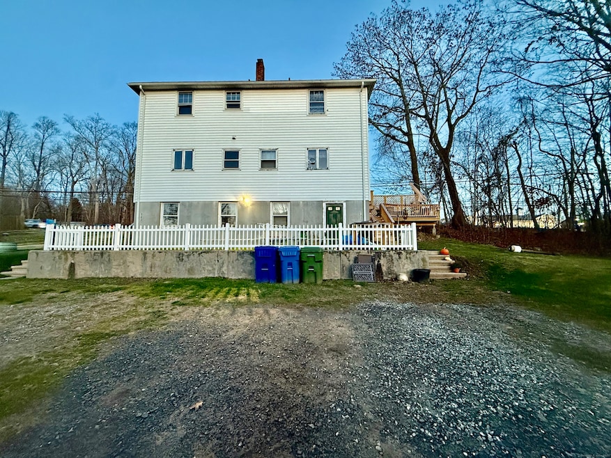
About This Home
Discover an exceptional investment opportunity or ideal owner-occupied home just moments from beautiful Lake Pocotopaug in East Hampton. This well-maintained two-unit duplex offers a total of 4 bedrooms, 4 full bathrooms, and 2,000 sq ft of comfortable living space. Each unit provides a bright and inviting layout with its own private entrance, spacious living room, 2 beds and 2 full baths, perfect for maximizing rental income or accommodating multi-generational living. Set on a lovely lot close to the lake, parks, restaurants, and East Hampton's charming town center, this property blends convenience with the tranquility of a lakeside community. Whether you're looking to invest, live in one unit while renting the other, or create the perfect shared living arrangement, this duplex delivers flexibility, value, and an unbeatable location.
Listing Agent
Countryside Realty Brokerage Phone: (860) 450-2682 License #REB.0751350 Listed on: 12/03/2025
Property Details
Home Type
- Multi-Family
Est. Annual Taxes
- $5,505
Year Built
- Built in 1950
Lot Details
- 13,068 Sq Ft Lot
- Lot Has A Rolling Slope
Parking
- Parking Deck
Home Design
- 2,000 Sq Ft Home
- Side-by-Side
- Concrete Foundation
- Frame Construction
- Asphalt Shingled Roof
- Vinyl Siding
Bedrooms and Bathrooms
- 4 Bedrooms
- 4 Full Bathrooms
Attic
- Storage In Attic
- Attic or Crawl Hatchway Insulated
Partially Finished Basement
- Walk-Out Basement
- Basement Fills Entire Space Under The House
Outdoor Features
- Deck
Utilities
- Baseboard Heating
- Heating System Uses Oil
- Private Company Owned Well
- Oil Water Heater
Community Details
- 2 Units
Listing and Financial Details
- Assessor Parcel Number 981174
Map
Home Values in the Area
Average Home Value in this Area
Tax History
| Year | Tax Paid | Tax Assessment Tax Assessment Total Assessment is a certain percentage of the fair market value that is determined by local assessors to be the total taxable value of land and additions on the property. | Land | Improvement |
|---|---|---|---|---|
| 2025 | $5,505 | $138,630 | $33,920 | $104,710 |
| 2024 | $5,273 | $138,630 | $33,920 | $104,710 |
| 2023 | $4,999 | $138,630 | $33,920 | $104,710 |
| 2022 | $4,805 | $138,630 | $33,920 | $104,710 |
| 2021 | $4,787 | $138,630 | $33,920 | $104,710 |
| 2020 | $4,576 | $138,080 | $34,560 | $103,520 |
| 2019 | $4,738 | $142,970 | $35,530 | $107,440 |
| 2018 | $4,478 | $142,970 | $35,530 | $107,440 |
| 2017 | $4,478 | $142,970 | $35,530 | $107,440 |
| 2016 | $4,209 | $142,970 | $35,530 | $107,440 |
| 2015 | $3,621 | $130,350 | $34,200 | $96,150 |
| 2014 | $3,151 | $130,350 | $34,200 | $96,150 |
Property History
| Date | Event | Price | List to Sale | Price per Sq Ft |
|---|---|---|---|---|
| 04/27/2026 04/27/26 | Pending | -- | -- | -- |
| 04/08/2026 04/08/26 | Price Changed | $499,900 | -4.8% | $250 / Sq Ft |
| 12/03/2025 12/03/25 | Price Changed | $524,900 | -3.3% | $262 / Sq Ft |
| 12/03/2025 12/03/25 | For Sale | $542,900 | -- | $271 / Sq Ft |
Purchase History
We collect this data history from publicly available records. To have your information removed, we recommend requesting removal directly through your county’s website.
| Date | Type | Sale Price | Title Company |
|---|---|---|---|
| Warranty Deed | $220,000 | -- | |
| Warranty Deed | $220,000 | -- |
Mortgage History
We collect this data history from publicly available records. To have your information removed, we recommend requesting removal directly through your county’s website.
| Date | Status | Loan Amount | Loan Type |
|---|---|---|---|
| Previous Owner | $40,000 | No Value Available | |
| Previous Owner | $123,000 | No Value Available | |
| Previous Owner | $130,900 | No Value Available |
Source: SmartMLS
MLS Number: 24142803
APN: EHAM-000010A-000081-000072
Disclaimer: Certain information contained herein is derived from information provided by parties other than Homes.com. All information provided is deemed reliable, but is not guaranteed to be accurate and should be independently verified.
![]() IDX information is provided exclusively for personal, non-commercial use, and may not be used for any purpose other than to identify prospective properties consumers may be interested in purchasing. Information is deemed reliable but not guaranteed.
IDX information is provided exclusively for personal, non-commercial use, and may not be used for any purpose other than to identify prospective properties consumers may be interested in purchasing. Information is deemed reliable but not guaranteed.
- 6 North Hollow
- 3 Brook Trail
- 10 Mountain Trail
- 18 Brook Trail
- 306 Lake Vista Dr Unit 306
- 711 Lake Vista Dr Unit 711
- 805 Lake Vista Dr Unit 805
- 29 Namonee Trail
- 74 Spellman Point Rd
- 2 Town Line Dr
- 114 Lake Dr
- 18 Lake Blvd
- 26 Lake Blvd
- 6 Candlewood Dr
- 15 Beechcrest Dr
- 14 Mountainview Rd
- 12 Hale Rd
- 85 N Main St Unit 86
- 14 Lakewood Rd
- 22 W High St

Ask me questions while you tour the home.