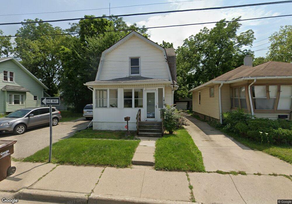
1411 W Malcolm x St Lansing, MI 48915
Westside NeighborhoodEstimated Value: $89,249 - $142,000
3
Beds
1
Bath
1,560
Sq Ft
$73/Sq Ft
Est. Value
About This Home
This home is located at 1411 W Malcolm x St, Lansing, MI 48915 and is currently estimated at $114,312, approximately $73 per square foot. 1411 W Malcolm x St is a home located in Ingham County with nearby schools including Riddle Elementary School, Pattengill Academy, and J.W. Sexton High School.
Ownership History
Date
Name
Owned For
Owner Type
Purchase Details
Closed on
Apr 21, 2026
Sold by
Stanfield Darrell
Bought by
Charles Mccants Llc
Current Estimated Value
Purchase Details
Closed on
Apr 17, 2013
Sold by
Stanfield Darrell H
Bought by
Stanfield Darrel H and Withers Johny
Purchase Details
Closed on
Oct 25, 2007
Sold by
Vandenberge Robert and Vandenberge Janice
Bought by
Washington Mutual Bank and Washington Mutual Bank Fa
Purchase Details
Closed on
Apr 20, 2007
Sold by
Magers Luke and Magers Erica L
Bought by
Vandenberge Robert and Vandenberge Janice
Home Financials for this Owner
Home Financials are based on the most recent Mortgage that was taken out on this home.
Original Mortgage
$56,250
Interest Rate
8%
Mortgage Type
Purchase Money Mortgage
Purchase Details
Closed on
Sep 2, 2005
Sold by
Department Of Treasury State Michigan
Bought by
Magers Luke A
Create a Home Valuation Report for This Property
The Home Valuation Report is an in-depth analysis detailing your home's value as well as a comparison with similar homes in the area
Home Values in the Area
Average Home Value in this Area
Purchase History
We collect this data history from publicly available records. To have your information removed, we recommend requesting removal directly through your county’s website.
| Date | Buyer | Sale Price | Title Company |
|---|---|---|---|
| Charles Mccants Llc | $65,000 | Verus Title Inc | |
| Stanfield Darrel H | -- | None Available | |
| Washington Mutual Bank | $59,758 | None Available | |
| Vandenberge Robert | $75,000 | Title Group | |
| Magers Luke A | $20,000 | None Available |
Source: Public Records
Mortgage History
We collect this data history from publicly available records. To have your information removed, we recommend requesting removal directly through your county’s website.
| Date | Status | Borrower | Loan Amount |
|---|---|---|---|
| Previous Owner | Vandenberge Robert | $56,250 |
Source: Public Records
Tax History
| Year | Tax Paid | Tax Assessment Tax Assessment Total Assessment is a certain percentage of the fair market value that is determined by local assessors to be the total taxable value of land and additions on the property. | Land | Improvement |
|---|---|---|---|---|
| 2025 | $1,927 | $39,100 | $4,200 | $34,900 |
| 2024 | $15 | $42,000 | $4,200 | $37,800 |
| 2023 | $1,809 | $36,300 | $4,200 | $32,100 |
| 2022 | $1,634 | $32,800 | $4,500 | $28,300 |
| 2021 | $1,601 | $30,100 | $4,500 | $25,600 |
| 2020 | $1,590 | $28,900 | $4,500 | $24,400 |
| 2019 | $2,645 | $26,300 | $4,500 | $21,800 |
| 2018 | $1,429 | $23,900 | $4,500 | $19,400 |
| 2017 | $1,368 | $23,900 | $4,500 | $19,400 |
| 2016 | $2,466 | $23,500 | $4,500 | $19,000 |
| 2015 | $2,466 | $22,900 | $9,092 | $13,808 |
| 2014 | $2,466 | $23,700 | $12,500 | $11,200 |
Source: Public Records
Map
Nearby Homes
- 1601 W Malcolm x St
- 1510 W Saint Joseph St
- 1519 W Lenawee St
- 1140 W Lenawee St
- 609 Everett Dr
- 524 Everett Dr
- 914 W Hillsdale St
- 324 West St
- 437 S Verlinden Ave
- 2136 Bruce Ave
- 1912 Moores River Dr
- 1136 W Allegan St
- 1120 Alsdorf St
- 1403 W Michigan Ave
- 1400 W Michigan Ave
- 1328 W Michigan Ave
- 1309 Hammond St
- 1027 Britten Ave
- 1615 W Ottawa St
- 1123 W Ottawa St
- 1411 W Malcolm x St
- 1415 W Malcolm x St
- 1403 W Malcolm x St
- 1403 W Malcolm x St
- 814 Max Ave
- 1401 W Malcolm x St
- 1423 W Malcolm x St
- 816 Max Ave
- 1425 W Malcolm x St
- 805 Middle St
- 1425 W Malcolm x St
- 811 Middle St
- 818 Max Ave
- 817 Middle St
- 820 Max Ave
- 1501 W Malcolm x St
- 1501 W Malcolm x St
- 822 Max Ave
- 1416 William St
- 808 Middle St
Your Personal Tour Guide
Ask me questions while you tour the home.