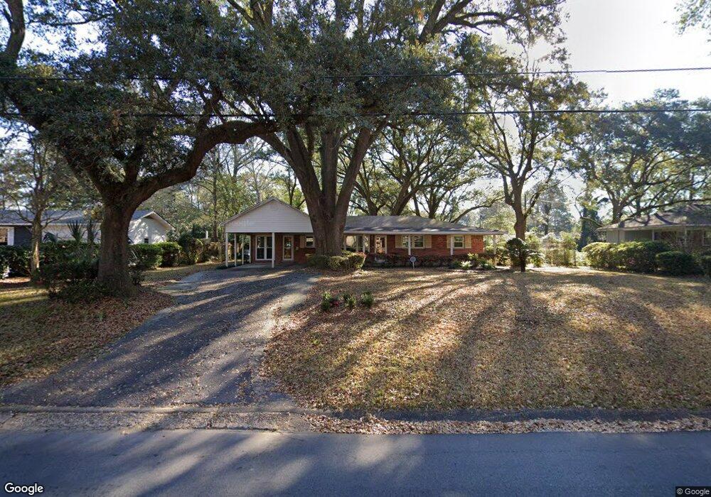
1413 Polaris Dr Mobile, AL 36693
Skyland Park NeighborhoodEstimated Value: $234,000 - $258,000
3
Beds
2
Baths
2,125
Sq Ft
$116/Sq Ft
Est. Value
About This Home
This home is located at 1413 Polaris Dr, Mobile, AL 36693 and is currently estimated at $247,233, approximately $116 per square foot. 1413 Polaris Dr is a home located in Mobile County with nearby schools including Kate Shepard Elementary School, Burns Middle School, and Murphy High School.
Ownership History
Date
Name
Owned For
Owner Type
Purchase Details
Closed on
Aug 25, 2022
Sold by
Mcmillian Ruby M
Bought by
Wade Melvin C
Current Estimated Value
Home Financials for this Owner
Home Financials are based on the most recent Mortgage that was taken out on this home.
Original Mortgage
$216,015
Outstanding Balance
$205,961
Interest Rate
5.51%
Mortgage Type
FHA
Estimated Equity
$41,272
Purchase Details
Closed on
Jul 17, 2001
Sold by
Strachan Danny C and Strachan Donna L
Bought by
Mcmillian John H and Mcmillian Ruby M
Home Financials for this Owner
Home Financials are based on the most recent Mortgage that was taken out on this home.
Original Mortgage
$111,652
Interest Rate
7.16%
Mortgage Type
VA
Purchase Details
Closed on
Apr 7, 1999
Sold by
Degervais Sydney T
Bought by
Degervais Sydney and Guy Jacquelyn
Create a Home Valuation Report for This Property
The Home Valuation Report is an in-depth analysis detailing your home's value as well as a comparison with similar homes in the area
Home Values in the Area
Average Home Value in this Area
Purchase History
| Date | Buyer | Sale Price | Title Company |
|---|---|---|---|
| Wade Melvin C | $220,000 | Bc Law Firm Pa | |
| Mcmillian John H | -- | -- | |
| Degervais Sydney | -- | -- |
Source: Public Records
Mortgage History
| Date | Status | Borrower | Loan Amount |
|---|---|---|---|
| Open | Wade Melvin C | $216,015 | |
| Previous Owner | Mcmillian John H | $111,652 |
Source: Public Records
Tax History
| Year | Tax Paid | Tax Assessment Tax Assessment Total Assessment is a certain percentage of the fair market value that is determined by local assessors to be the total taxable value of land and additions on the property. | Land | Improvement |
|---|---|---|---|---|
| 2025 | $1,307 | $23,470 | $3,000 | $20,470 |
| 2024 | $1,307 | $23,790 | $3,100 | $20,690 |
| 2023 | $1,159 | $20,860 | $2,750 | $18,110 |
| 2022 | $0 | $13,100 | $2,500 | $10,600 |
| 2021 | $0 | $13,100 | $2,500 | $10,600 |
| 2020 | $698 | $12,860 | $2,020 | $10,840 |
| 2019 | $698 | $12,960 | $0 | $0 |
| 2018 | $698 | $12,960 | $0 | $0 |
| 2017 | $698 | $12,960 | $0 | $0 |
| 2016 | $715 | $13,260 | $0 | $0 |
| 2013 | $702 | $12,880 | $0 | $0 |
Source: Public Records
Map
Nearby Homes
- 4359 Antares Ln
- 3058 Yorkwood Rd E
- 0 Lee's Ln Unit 2
- 4260 Aldebaran Way
- 4371 Antares Ln
- 1409 Altair Ln Unit 1
- 4160 Aldebaran Way
- 5166 Maudelayne Dr S
- 2705 Woodcliff Dr E Unit 1
- 3109 Grishilde Dr
- 2965 Longleaf Dr
- 2858 Woodmere St W
- 5361 Larchmont Dr
- 4103 Belvedere St
- 5404 Larchmont Dr
- 1586 Regency Dr
- 4413 Radian Dr
- 4110 Lake Cir N
- 5012 Burma Rd W
- 5505 White Pine Dr
- 1417 Polaris Dr
- 1409 Polaris Dr
- 1408 Vega Dr
- 1405 Polaris Dr
- 1421 Polaris Dr
- 1412 Vega Dr
- 1412 Polaris Dr
- 1404 Vega Dr
- 1408 Polaris Dr
- 1416 Vega Dr
- 1425 Polaris Dr
- 1401 Polaris Dr
- 1400 Vega Dr
- 1404 Polaris Dr
- 1420 Polaris Dr
- 3055 Demetropolis Rd
- 3059 Demetropolis Rd
- 3051 Demetropolis Rd
- 1429 Polaris Dr
- lot 15 Polaris Dr
Your Personal Tour Guide
Ask me questions while you tour the home.