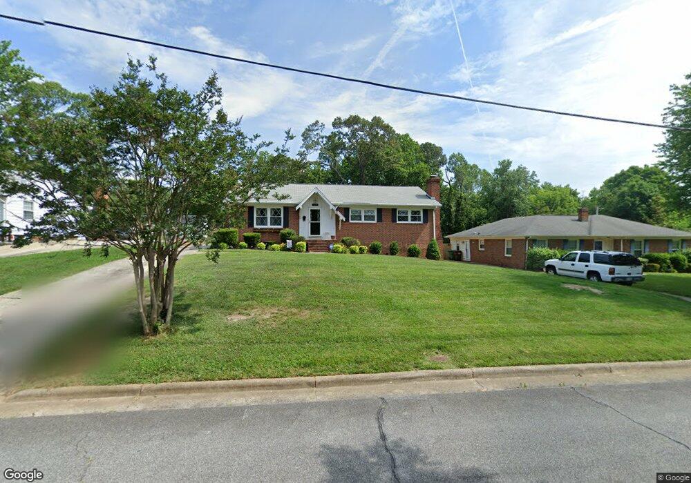
1419 Grantham Dr High Point, NC 27265
Oak View NeighborhoodEstimated Value: $227,000 - $273,000
3
Beds
2
Baths
2,053
Sq Ft
$122/Sq Ft
Est. Value
About This Home
This home is located at 1419 Grantham Dr, High Point, NC 27265 and is currently estimated at $250,603, approximately $122 per square foot. 1419 Grantham Dr is a home located in Guilford County with nearby schools including Montlieu Academy of Technology, Welborn Academy of Science & Technology, and T.W. Andrews High School.
Ownership History
Date
Name
Owned For
Owner Type
Purchase Details
Closed on
Aug 8, 2013
Sold by
Howey George P and Howey Lori Faye Bovender
Bought by
Howey George P
Current Estimated Value
Home Financials for this Owner
Home Financials are based on the most recent Mortgage that was taken out on this home.
Original Mortgage
$116,947
Outstanding Balance
$86,621
Interest Rate
4.29%
Mortgage Type
New Conventional
Estimated Equity
$163,982
Purchase Details
Closed on
May 1, 2008
Sold by
Frazier Henry T and Frazier Cora G
Bought by
Howey George P
Home Financials for this Owner
Home Financials are based on the most recent Mortgage that was taken out on this home.
Original Mortgage
$122,550
Interest Rate
5.84%
Mortgage Type
Purchase Money Mortgage
Create a Home Valuation Report for This Property
The Home Valuation Report is an in-depth analysis detailing your home's value as well as a comparison with similar homes in the area
Home Values in the Area
Average Home Value in this Area
Purchase History
| Date | Buyer | Sale Price | Title Company |
|---|---|---|---|
| Howey George P | -- | None Available | |
| Howey George P | $129,000 | None Available |
Source: Public Records
Mortgage History
| Date | Status | Borrower | Loan Amount |
|---|---|---|---|
| Open | Howey George P | $116,947 | |
| Closed | Howey George P | $122,550 |
Source: Public Records
Tax History
| Year | Tax Paid | Tax Assessment Tax Assessment Total Assessment is a certain percentage of the fair market value that is determined by local assessors to be the total taxable value of land and additions on the property. | Land | Improvement |
|---|---|---|---|---|
| 2025 | $1,960 | $142,200 | $35,000 | $107,200 |
| 2024 | $1,960 | $142,200 | $35,000 | $107,200 |
| 2023 | $1,960 | $142,200 | $35,000 | $107,200 |
| 2022 | $1,917 | $142,200 | $35,000 | $107,200 |
| 2021 | $1,607 | $116,600 | $25,000 | $91,600 |
| 2020 | $1,607 | $116,600 | $25,000 | $91,600 |
| 2019 | $1,607 | $116,600 | $0 | $0 |
| 2018 | $1,599 | $116,600 | $0 | $0 |
| 2017 | $1,599 | $116,600 | $0 | $0 |
| 2016 | $1,417 | $101,000 | $0 | $0 |
| 2015 | $1,424 | $101,000 | $0 | $0 |
| 2014 | $1,448 | $101,000 | $0 | $0 |
Source: Public Records
Map
Nearby Homes
- 1526 Ann Arbor Ct
- 1808 Guyer St
- 1818 Guyer St Unit C
- 1604 E Lexington Ave
- 2005 Carlisle Way
- 1519 Mcguinn Dr
- 1415 Wiltshire St
- 1509 & 1511 Wiltshire St
- 1110 Forrest St
- 1108 Forrest St
- 1445 Bailey Cir
- 1717 Carolina St
- 1719 Carolina St
- 1907 Boulding Ave
- 2507 Suffolk Ave
- 613 Woodridge Ln
- 1120 Carolina St
- 801 E Lexington Ave
- 916 Forrest St
- 828 Circle Dr
- 1421 Grantham Dr
- 1417 Grantham Dr
- 1423 Grantham Dr
- 1546 Ann Arbor Ct
- 1415 Grantham Dr
- 1420 Grantham Dr
- 1418 Grantham Dr
- 1422 Grantham Dr
- 1544 Ann Arbor Ct
- 1548 Ann Arbor Ct
- 1610 Grantham Dr
- 1416 Grantham Dr
- 1411 Grantham Dr
- 1608 Grantham Dr
- 1606 Grantham Dr
- 1635 Arden Place
- 1542 Ann Arbor Ct
- 1414 Grantham Dr
- 1550 Ann Arbor Ct
- 1409 Grantham Dr
Your Personal Tour Guide
Ask me questions while you tour the home.