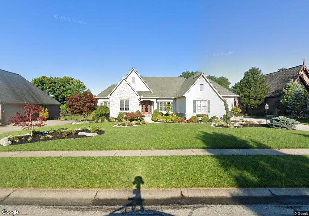
1421 Davids Way Cincinnati, OH 45233
Estimated Value: $611,000 - $777,000
3
Beds
4
Baths
2,225
Sq Ft
$308/Sq Ft
Est. Value
About This Home
This home is located at 1421 Davids Way, Cincinnati, OH 45233 and is currently estimated at $685,036, approximately $307 per square foot. 1421 Davids Way is a home located in Hamilton County with nearby schools including John Foster Dulles Elementary School, Rapid Run Middle School, and Oak Hills High School.
Ownership History
Date
Name
Owned For
Owner Type
Purchase Details
Closed on
Feb 23, 2018
Sold by
Loughrey John R and Loughrey Kathleen A
Bought by
Loughrey John R and Loughrey Kathleen A
Current Estimated Value
Purchase Details
Closed on
Mar 8, 2005
Sold by
Loughrey Kathleen A
Bought by
Loughrey John R and Loughrey Kathleen A
Purchase Details
Closed on
Dec 22, 2003
Sold by
Beech Grove Group Llc
Bought by
Loughrey Kathleen A
Create a Home Valuation Report for This Property
The Home Valuation Report is an in-depth analysis detailing your home's value as well as a comparison with similar homes in the area
Home Values in the Area
Average Home Value in this Area
Purchase History
| Date | Buyer | Sale Price | Title Company |
|---|---|---|---|
| Loughrey John R | -- | None Available | |
| Loughrey John R | -- | Lighthouse Title Services | |
| Loughrey Kathleen A | $105,000 | -- |
Source: Public Records
Tax History
| Year | Tax Paid | Tax Assessment Tax Assessment Total Assessment is a certain percentage of the fair market value that is determined by local assessors to be the total taxable value of land and additions on the property. | Land | Improvement |
|---|---|---|---|---|
| 2025 | $10,307 | $198,296 | $34,230 | $164,066 |
| 2024 | $10,050 | $198,296 | $34,230 | $164,066 |
| 2023 | $10,060 | $198,296 | $34,230 | $164,066 |
| 2022 | $10,349 | $172,984 | $41,160 | $131,824 |
| 2021 | $9,291 | $172,984 | $41,160 | $131,824 |
| 2020 | $9,412 | $172,984 | $41,160 | $131,824 |
| 2019 | $9,210 | $154,452 | $36,750 | $117,702 |
| 2018 | $9,224 | $154,452 | $36,750 | $117,702 |
| 2017 | $8,692 | $154,452 | $36,750 | $117,702 |
| 2016 | $8,482 | $150,500 | $36,750 | $113,750 |
| 2015 | $8,555 | $150,500 | $36,750 | $113,750 |
| 2014 | $8,567 | $150,500 | $36,750 | $113,750 |
| 2013 | $8,003 | $150,500 | $36,750 | $113,750 |
Source: Public Records
Map
Nearby Homes
- 1711 Ebenezer Rd
- 1659 Devils Backbone Rd
- 1287 Heather Ridge
- 1259 Wexford Ln
- 6009 Cleves Warsaw Pike
- 2202 Ebenezer Rd
- 5949 Cleves Warsaw Pike
- 6090 Muddy Creek Rd
- 2239 Quail Run Farm Ln
- 2417 Quail Run Farm Ln
- 5749 Beech Grove Ln
- 2659 Devils Backbone Rd
- 5671 Julmar Dr
- 5695 Antoninus Dr
- 5690 Candlelite Terrace
- 833 Neeb Rd Unit 4
- 837 Neeb Rd
- 6944 Old Stone Ridge
- 1006 Pineknot Dr
- 1681 van Blaricum Rd
- 1413 Davids Way
- 31 Georges Way
- 1429 Davids Way
- 1397 Wexford Ln
- 1437 Davids Way
- 1405 Davids Way
- 6 Davids Way
- 1893 Devils Backbone Rd
- 6161 Georges Way
- 1395 Wexford Ln
- 1445 Davids Way
- 1400 Davids Way
- 1440 Davids Way
- 1389 Wexford Ln
- 6153 Georges Way
- 1453 Davids Way
- 6140 Georges Way
- 1386 Wexford Ln
- 6145 Georges Way
- Lot Georges Way
Your Personal Tour Guide
Ask me questions while you tour the home.