
Seller's Agent in 2026
Genevieve Partsch
eXp Realty LLC
(541) 543-3610
5 in this area
66 Total Sales
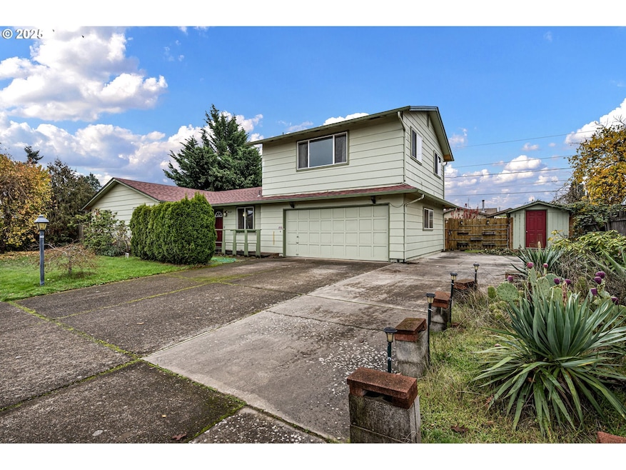


Welcome to a home with solid potential in a great Springfield location. This property offers a newer roof, a large yard, and an upstairs flex area with two separate spaces that can be used for work, hobbies, or additional living options. The layout is comfortable and functional, with room to update and make it your own over time. The spacious yard provides plenty of room for gardening, outdoor gatherings, or future improvements. Inside, the home has good natural light, a practical floor plan, and possibilities for someone who wants to add their own style and finishing touches.Its location is another standout feature with easy access to shopping, nearby parks, and the McKenzie River for recreation and relaxation. Whether you are looking for a home to personalize, a property with strong structural updates already complete, or a place with flexible space for your needs, this home offers the opportunity to create something special.
Last Agent to Sell the Property
eXp Realty LLC License #200510112 Listed on: 11/20/2025
| Date | Type | Sale Price | Title Company |
|---|---|---|---|
| Warranty Deed | $390,000 | Western Title | |
| Warranty Deed | $136,000 | Western Pioneer Title Co | |
| Warranty Deed | $130,000 | Western Pioneer Title Co |
| Date | Status | Loan Amount | Loan Type |
|---|---|---|---|
| Open | $378,300 | New Conventional | |
| Previous Owner | $121,500 | No Value Available |
| Date | Event | Price | List to Sale | Price per Sq Ft |
|---|---|---|---|---|
| 03/04/2026 03/04/26 | Sold | $390,000 | -9.3% | $236 / Sq Ft |
| 02/09/2026 02/09/26 | Pending | -- | -- | -- |
| 02/05/2026 02/05/26 | Price Changed | $430,000 | -4.4% | $260 / Sq Ft |
| 01/09/2026 01/09/26 | Price Changed | $450,000 | -2.2% | $272 / Sq Ft |
| 11/20/2025 11/20/25 | For Sale | $460,000 | -- | $278 / Sq Ft |
| Year | Tax Paid | Tax Assessment Tax Assessment Total Assessment is a certain percentage of the fair market value that is determined by local assessors to be the total taxable value of land and additions on the property. | Land | Improvement |
|---|---|---|---|---|
| 2025 | $3,229 | $258,744 | -- | -- |
| 2024 | $3,138 | $251,208 | -- | -- |
| 2023 | $3,138 | $243,892 | $0 | $0 |
| 2022 | $2,986 | $236,789 | $0 | $0 |
| 2021 | $2,914 | $229,893 | $0 | $0 |
| 2020 | $2,824 | $223,198 | $0 | $0 |
| 2019 | $2,716 | $216,698 | $0 | $0 |
| 2018 | $2,607 | $204,259 | $0 | $0 |
| 2017 | $2,523 | $204,259 | $0 | $0 |
| 2016 | $2,466 | $198,310 | $0 | $0 |
| 2015 | $2,410 | $192,534 | $0 | $0 |
| 2014 | $2,297 | $186,926 | $0 | $0 |
Seller's Agent in 2026
Genevieve Partsch
eXp Realty LLC
(541) 543-3610
5 in this area
66 Total Sales
Buyer's Agent in 2026
Amber Tena
John L. Scott Eugene
(541) 606-3949
4 in this area
87 Total Sales
Source: Regional Multiple Listing Service (RMLS)
MLS Number: 367685721
APN: 1045697
Disclaimer: Certain information contained herein is derived from information provided by parties other than Homes.com. All information provided is deemed reliable, but is not guaranteed to be accurate and should be independently verified.
![]() The content relating to real estate for sale on this web site comes in part from the IDX program of the RMLS™ of Portland, Oregon. Real estate listings held by brokerage firms other than Ten-X are marked with the RMLS™ logo, and detailed information about these properties includes the names of the listing brokers. Listing content is copyright © 2026 RMLS™, Portland, Oregon. Some properties which appear for sale on this web site may subsequently have sold or may no longer be available. All information provided is deemed reliable but is not guaranteed and should be independently verified.
The content relating to real estate for sale on this web site comes in part from the IDX program of the RMLS™ of Portland, Oregon. Real estate listings held by brokerage firms other than Ten-X are marked with the RMLS™ logo, and detailed information about these properties includes the names of the listing brokers. Listing content is copyright © 2026 RMLS™, Portland, Oregon. Some properties which appear for sale on this web site may subsequently have sold or may no longer be available. All information provided is deemed reliable but is not guaranteed and should be independently verified.
Ask me questions while you tour the home.