Estimated Value: $580,000 - $748,000
2
Beds
1
Bath
1,195
Sq Ft
$562/Sq Ft
Est. Value
About This Home
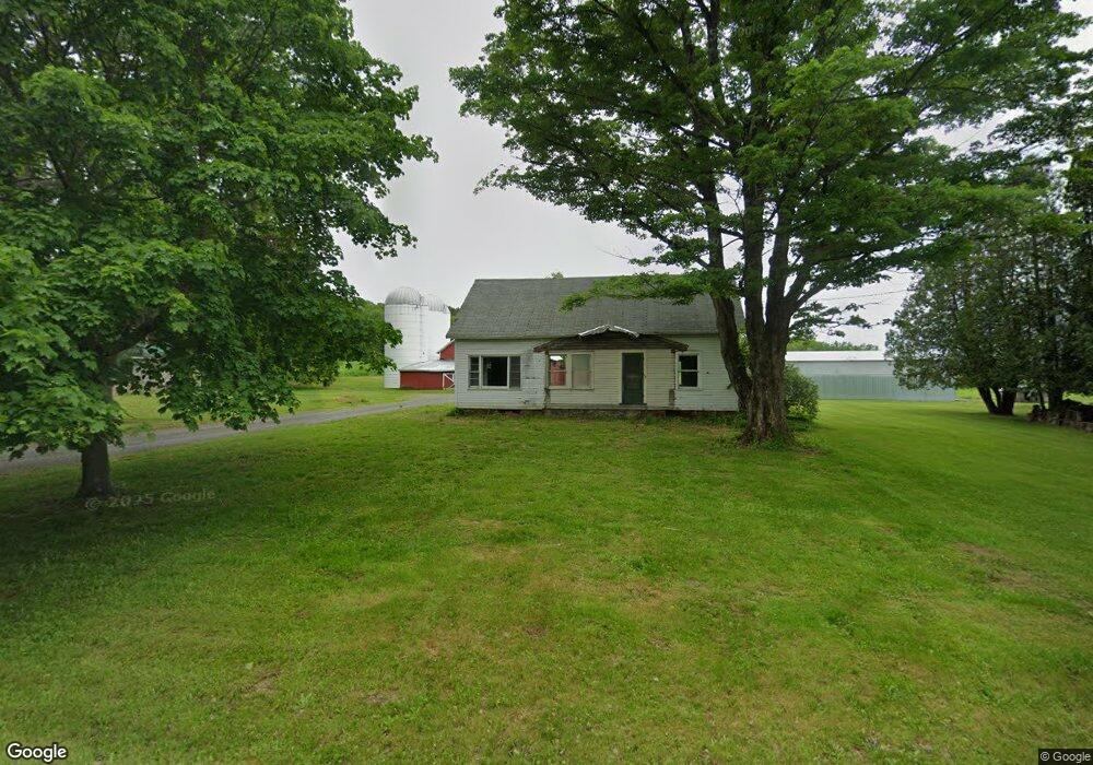
This home is located at 144 Dearstyne Rd, Troy, NY 12180 and is currently estimated at $672,099, approximately $562 per square foot. 144 Dearstyne Rd is a home located in Rensselaer County with nearby schools including Tamarac Elementary School and Tamarac Middle School High School.
Ownership History
Date
Name
Owned For
Owner Type
Purchase Details
Closed on
Jun 3, 2021
Sold by
Pollock Robert F
Bought by
Dearstyne Farms Llc
Current Estimated Value
Home Financials for this Owner
Home Financials are based on the most recent Mortgage that was taken out on this home.
Original Mortgage
$600,000
Outstanding Balance
$543,225
Interest Rate
2.9%
Mortgage Type
Purchase Money Mortgage
Estimated Equity
$128,874
Purchase Details
Closed on
Mar 4, 2021
Sold by
Pollock Robert F
Bought by
Pollock Adam
Purchase Details
Closed on
Nov 18, 2019
Sold by
Constance S Pollock Irt
Bought by
Pollock Robert F
Purchase Details
Closed on
Apr 23, 2015
Sold by
Pollock Constance
Bought by
Pollock - Trustee Robert
Create a Home Valuation Report for This Property
The Home Valuation Report is an in-depth analysis detailing your home's value as well as a comparison with similar homes in the area
Home Values in the Area
Average Home Value in this Area
Purchase History
| Date | Buyer | Sale Price | Title Company |
|---|---|---|---|
| Dearstyne Farms Llc | $650,000 | None Available | |
| Pollock Adam | $37,500 | None Available | |
| Pollock Robert F | -- | -- | |
| Pollock - Trustee Robert | -- | Patricia Shevy |
Source: Public Records
Mortgage History
| Date | Status | Borrower | Loan Amount |
|---|---|---|---|
| Open | Dearstyne Farms Llc | $600,000 |
Source: Public Records
Tax History
| Year | Tax Paid | Tax Assessment Tax Assessment Total Assessment is a certain percentage of the fair market value that is determined by local assessors to be the total taxable value of land and additions on the property. | Land | Improvement |
|---|---|---|---|---|
| 2024 | $10,978 | $99,100 | $46,800 | $52,300 |
| 2023 | $10,874 | $99,100 | $46,800 | $52,300 |
| 2022 | $10,870 | $99,100 | $46,800 | $52,300 |
| 2021 | $3,077 | $99,100 | $46,800 | $52,300 |
| 2020 | $9,650 | $102,600 | $50,300 | $52,300 |
| 2019 | $9,650 | $102,600 | $50,300 | $52,300 |
| 2018 | $9,650 | $102,600 | $50,300 | $52,300 |
| 2017 | $9,340 | $102,600 | $50,300 | $52,300 |
| 2016 | $9,444 | $102,600 | $50,300 | $52,300 |
| 2015 | -- | $102,600 | $50,300 | $52,300 |
| 2014 | -- | $102,600 | $50,300 | $52,300 |
Source: Public Records
Map
Nearby Homes
- 4177 State Highway 2
- 18 Walter Rd
- 4048 New York 2
- 13 Veterans St
- 3689 Ny Highway 2
- 70 Town Office Rd
- 8 Creek Rd
- 31 Colehamer Ave
- 8 Saddle Hill Rd
- 38 Weatherwax Rd
- 7 Saddle Hill Rd
- 67 Guiliana Blvd
- 1137 Blue Factory Hill Rd Unit 11
- 77 Davitt Lake Rd
- 120 Weatherwax Rd
- 128 Abbey Rd
- 568 Nys 355 Cooper Hill Rd
- 9345 Ny Highway 66
- 11 Petticoat Ln
- 1 Keyes Ln
- 0 Dearstyne Rd
- 135 Dearstyne Rd
- 168 Dearstyne Rd
- 195 Dearstyne Rd
- 203 Dearstyne Rd
- 196 Dearstyne Rd
- 455 Farm To Market Rd
- 212 Dearstyne Rd
- 71 Dearstyne Rd
- 71 Dearstyne Rd
- 35 Dearstyne Rd
- 499 Farm To Market Rd
- 615 Farm To Market Rd
- 419 Farm To Market Rd
- 513 Farm To Market Rd
- 411 Farm To Market Rd
- 924 Farm To Market Rd
- 2 Penny Royal Ln
- 490 Farm To Market Rd
- 512 Farm To Market Rd
Your Personal Tour Guide
Ask me questions while you tour the home.