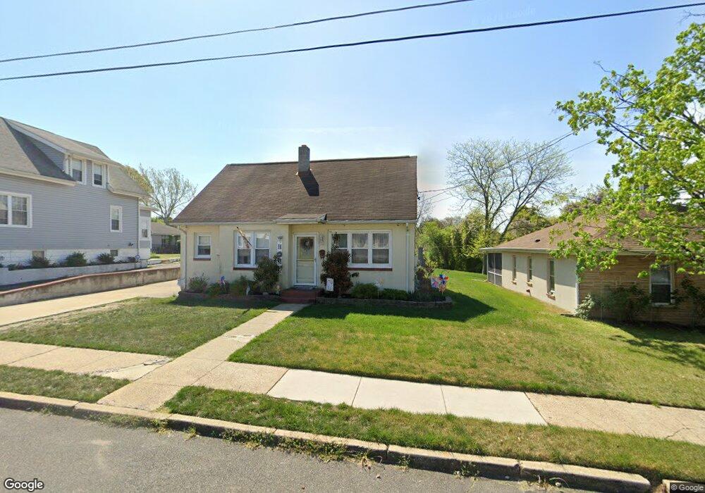
144 Thompson Ave Gibbstown, NJ 08027
Estimated Value: $215,652 - $331,000
Studio
--
Bath
1,443
Sq Ft
$196/Sq Ft
Est. Value
About This Home
This home is located at 144 Thompson Ave, Gibbstown, NJ 08027 and is currently estimated at $282,163, approximately $195 per square foot. 144 Thompson Ave is a home located in Gloucester County with nearby schools including Nehaunsey Middle School and Guardian Angels Regional School.
Ownership History
Date
Name
Owned For
Owner Type
Purchase Details
Closed on
May 25, 2001
Sold by
Mogar Michael J and Mogar Deborah
Bought by
Mogar Michael J
Current Estimated Value
Home Financials for this Owner
Home Financials are based on the most recent Mortgage that was taken out on this home.
Original Mortgage
$90,000
Interest Rate
7.15%
Create a Home Valuation Report for This Property
The Home Valuation Report is an in-depth analysis detailing your home's value as well as a comparison with similar homes in the area
Home Values in the Area
Average Home Value in this Area
Purchase History
| Date | Buyer | Sale Price | Title Company |
|---|---|---|---|
| Mogar Michael J | -- | Fidelity National Title Ins |
Source: Public Records
Mortgage History
| Date | Status | Borrower | Loan Amount |
|---|---|---|---|
| Closed | Mogar Michael J | $90,000 |
Source: Public Records
Tax History
| Year | Tax Paid | Tax Assessment Tax Assessment Total Assessment is a certain percentage of the fair market value that is determined by local assessors to be the total taxable value of land and additions on the property. | Land | Improvement |
|---|---|---|---|---|
| 2025 | $4,266 | $123,900 | $23,300 | $100,600 |
| 2024 | $4,042 | $123,900 | $23,300 | $100,600 |
| 2023 | $4,042 | $123,900 | $23,300 | $100,600 |
| 2022 | $4,044 | $123,900 | $23,300 | $100,600 |
| 2021 | $4,002 | $123,900 | $23,300 | $100,600 |
| 2020 | $4,058 | $123,900 | $23,300 | $100,600 |
| 2019 | $4,060 | $123,900 | $23,300 | $100,600 |
| 2018 | $3,945 | $123,900 | $23,300 | $100,600 |
| 2017 | $3,850 | $123,900 | $23,300 | $100,600 |
| 2016 | $3,807 | $123,900 | $23,300 | $100,600 |
| 2015 | $3,685 | $123,900 | $23,300 | $100,600 |
| 2014 | $3,526 | $123,900 | $23,300 | $100,600 |
Source: Public Records
Map
Nearby Homes
- 312 Croce Ave
- 255 Elizabeth Ave
- 403 W Broad St
- L18 20 W Broad St
- 318 W Buck St
- 311 Morton Ave
- 37 Harmony Rd
- 1224 Heddon Ave
- 1221 Walter Ave
- 227 W Buck St
- 227 W Washington St
- 1003 Hoffman Ave
- 1534 Pine St
- 1519 Pine St
- 1265 Walter Ave
- 205 W Adams St
- 122 W Washington St
- 26 W Broad St
- 17 W Wood St
- 29 W Madison St
- 140 Thompson Ave
- 150 Thompson Ave
- 136 Thompson Ave
- 925 Ladner Ave
- 130 Thompson Ave
- 933 Ladner Ave
- 137 Thompson Ave
- 135 Thompson Ave
- 126 Thompson Ave
- 129 Thompson Ave
- 143 Thompson Ave
- 125 Thompson Ave
- 120 Thompson Ave
- 939 Ladner Ave
- 812 E Broad St
- 116 Thompson Ave
- 912 Berkley Rd
- 914 Berkley Rd
- 918 Berkley Rd
- 131 Newton Ave
Your Personal Tour Guide
Ask me questions while you tour the home.